Port Elgin, New Brunswick
Port Elgin is a Canadian village in Westmorland County, New Brunswick. It is located near the Nova Scotia border at the mouth of the Gaspereaux River where it empties into the Northumberland Strait's Baie Verte.
Port Elgin | |
|---|---|
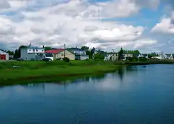 Port Elgin in 2007 | |
| Motto(s): "Your Port of Call" | |
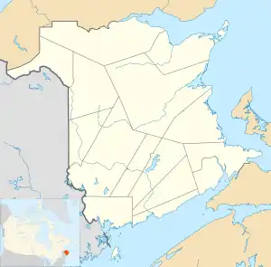 Port Elgin Location of Port Elgin within New Brunswick. | |
| Coordinates: 46°04′59″N 64°09′29″W | |
| Country | Canada |
| Province | New Brunswick |
| County | Westmorland |
| Established | 1690 |
| Government | |
| • Mayor | Judy Scott |
| • MP | Dominic LeBlanc |
| • MLA | Bernard LeBlanc |
| Area | |
| • Land | 2.66 km2 (1.03 sq mi) |
| Elevation | 2 m (5 ft) |
| Highest elevation | 4 m (14 ft) |
| Lowest elevation | 0 m (0 ft) |
| Population (2016)[1] | |
| • Total | 408 |
| • Density | 153.5/km2 (398/sq mi) |
| Demonym(s) | Portelginian |
| Time zone | UTC-4 (AST) |
| • Summer (DST) | UTC-3 (ADT) |
| Postal code(s) | E4M |
| Area code(s) | 506 |
| Access Routes | |
| Dwellings | 196 |
| Website | www |
History
The village was founded by Acadians in 1690, but abandoned after the Expulsion of the Acadians in 1755. The earthworks of Fort Gaspareaux, a French military fortification from the Seven Years' War are located at the mouth of the river immediately east of the village.
Following the Seven Years' War and the American Revolutionary War, British Loyalists resettled in the area which was named Gaspareaux Town. Gaspareaux Town was renamed Port Elgin in 1847 in honour of Lord Elgin. The community was incorporated as a village in 1922, the first community in the province to do so.[2]
Throughout the 19th century and first half of the 20th century, Port Elgin experienced modest industrialization with a handful of small factories, tanneries, and sawmills. The village also saw some shipping activity with several wharves on a sheltered harbour at the mouth of the Gaspereau River. The New Brunswick and Prince Edward Island Railway was built through the village in the early 1880s, opening on September 9, 1886 to connect the Intercolonial Railway at Sackville with the seasonal port of Cape Tormentine which supported the winter iceboat service to Prince Edward Island; in 1917 this port became a terminal for the year-round ferry service to P.E.I.
Automobile traffic increased through the village in the 1920s after the P.E.I. ferries began to carry road vehicles. The Baie Verte Road ran west of the village through Baie Verte as "Main Street" and the Immigrant Road ran east of the village. In the 1960s a bypass for Route 16 as a result of Trans-Canada Highway project funding was constructed around Baie Verte and Port Elgin; a traffic circle called the "Port Elgin Rotary" was built at the intersection between Route 16 and Route 15 and Route 970.
The largest employer in the village is Atlantic Windows, which employs 200 persons year-round.[3] The second largest employer is Westford Nursing Home, which has about 30 full and part-time staff and provides permanent care facility for 29 persons as well as one relief-care bed.
The village has a single school, Port Elgin Regional School, which provides public schooling for grades K-8; this school district encompasses all surrounding areas running as far east as Cape Tormentine, north to Robichaud and west to Jolicure. The village also had its own high school but this was closed in the 1990s and high school students are now bused to Tantramar Regional High School in Sackville.
2010 coastal flooding
On January 2, 2010, the village experienced coastal flooding as a result of a storm surge from a nor'easter lifted cottages off their foundations and led to considerable damage to homes, forcing the declaration of a state of emergency in the village and surrounding area.[4] The damage incurred by this storm is thought to be in the area of $900,000.[5]
A second coastal flooding event occurred on December 21, 2010, when another storm surge from a nor'easter flooded sections of the village and surrounding area.[6]
Demographics
| Year | Pop. | ±% p.a. |
|---|---|---|
| 1981 | 504 | — |
| 1986 | 470 | −1.39% |
| 1991 | 490 | +0.84% |
| 1996 | 445 | −1.91% |
| 2001 | 436 | −0.41% |
| 2006 | 451 | +0.68% |
| 2011 | 418 | −1.51% |
| 2016 | 408 | −0.48% |
| Source: [7][8][1] | ||
| Income type | By CAD |
|---|---|
| Total income per capita | $23,968 |
| Median Household Income | $40,064 |
| Median Family Income | $50,048 |
| Language | Population | Pct (%) |
|---|---|---|
| English | 345 | 90.8% |
| French | 25 | 6.6% |
| English and French | 5 | 1.3% |
| Other languages | 5 | 1.3% |
See also
 Fort Monckton Lighthouse in 2006 | |
New Brunswick | |
| |
| Location | Gaspereaux Point Port Elgin New Brunswick Canada |
|---|---|
| Coordinates | 46°2′35.64″N 64°4′14.74″W |
| Year first constructed | 1908 (first) |
| Year first lit | 1971 (current) |
| Deactivated | 1971 (first) |
| Foundation | concrete base |
| Construction | fiberglass tower |
| Tower shape | cylindrical tower with light |
| Markings / pattern | red tower with a central white band |
| Tower height | 7 metres (23 ft) |
| Focal height | 10 metres (33 ft) |
| Light source | solar power |
| Range | 7 nautical miles (13 km; 8.1 mi)[9] |
| Characteristic | Fl W 3s. (seasonal) |
| Admiralty number | H1304 |
| CHS number | CCG 1086 |
| NGA number | 7844 |
| ARLHS number | CAN-183 |
| Managing agent | Parks Canada (Fort Gaspereaux National Historic Site) [10][9] |
References
- "Census Profile, 2016 Census: Port Elgin, Village [Census subdivision], New Brunswick". Statistics Canada. Retrieved October 4, 2019.
- History of Port Elgin Archived 2011-08-10 at the Wayback Machine
- is a champca/region/port_elgin.php
- "CBC News - Canada - Maritimes recover after 'weather bomb'". Cbc.ca. 2010-01-04. Retrieved 2010-02-26.
- "N.B. village seeks $750K in flood aid". Canadian Broadcasting Corporation. January 8, 2010. Retrieved 22 December 2010.
- "Eastern N.B. faces treacherous weather". Canadian Broadcasting Corporation. December 20, 2010. Retrieved 22 December 2010.
- Statistics Canada: 1996, 2001, 2006 census
- "2011 Census Profile: Port Elgin, New Brunswick". Statistics Canada. Retrieved October 4, 2019.
- List of Lights, Pub. 110: Greenland, The East Coasts of North and South America (Excluding Continental U.S.A. Except the East Coast of Florida) and the West Indies (PDF). List of Lights. United States National Geospatial-Intelligence Agency. 2015.
- Northern New Brunswick The Lighthouse Directory. University of North Carolina at Chapel Hill. Retrieved 21 March 2017
External links
- Village of Port Elgin
- Aids to Navigation Canadian Coast Guard