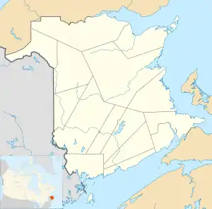
Cape Tormentine, New Brunswick
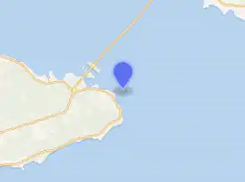
Cape Tormentine is a local service district in southeastern New Brunswick, Canada. It is located on the Northumberland Strait at the Abegweit Passage, the shortest crossing between Prince Edward Island and the mainland. It once flourished as a transportation hub between New Brunswick and Prince Edward Island but has been in decline since 1997 when the ferry service was closed due to the opening of the Confederation Bridge.[4] At the Canada 2011 Census the population was 108, three quarters what it was at the 2006 census.
 Cape Tormentine Outer Wharf Light | |
 New Brunswick | |
| |
| Location | Cape Tormentine New Brunswick Canada |
|---|---|
| Coordinates | 46°8′5.54″N 63°46′19.93″W |
| Year first constructed | 1901 (first) |
| Year first lit | 1940s (current) |
| Deactivated | 1997-1998 |
| Construction | masonry tower |
| Tower shape | quadrangular tower with balcony and lantern |
| Markings / pattern | white tower, red lantern roof |
| Tower height | 11 metres (36 ft) |
| Focal height | 12 metres (39 ft) |
| Original lens | seventh-order dioptric light |
| Light source | solar power |
| Range | 5 nautical miles (9.3 km; 5.8 mi)[1] |
| Characteristic | Iso R 2s. |
| Admiralty number | H1308 |
| CHS number | CCG 1090 |
| NGA number | 7824 |
| ARLHS number | CAN-112 |
| Managing agent | Canadian Coast Guard[2][3] |
Cape Tormentine is named for the eponymous cape. As an unincorporated community, it is part of the Bayfield local service district. For the purpose of Statistics Canada's census it is in Botsford Parish.
Freight and passenger terminal timeline
- 1827: the Northumberland Strait iceboat service, known as the Capes Route, begins operating across the strait to Cape Traverse, Prince Edward Island (PEI).
- 1873: under the terms of PEI joining Canadian Confederation, the federal government is obliged to provide "continuous steamship service" between the mainland and the island, and keep the iceboats running.
- 1886: the New Brunswick and Prince Edward Island Railway connects Cape Tormentine with Sackville, New Brunswick and thence to the Intercolonial Railway of Canada's Moncton to Truro line.
- 1917: the iceboats are replaced by an ice breaking train ferry, the SS Prince Edward Island, built by Armstrong Whitworth in England and operated by Canadian Government Railways. A new port was built to accommodate the ferry. She was an effective ice breaker, and could carry 12 interprovincial rail cars.[5]
- 1947: The ferry is replaced by the MV Abegweit. She measures 372 feet in length and displaces 7,000 tons. Her eight main engines generate 13,500 brake horsepower and drive propellers at both bow and stern. She could carry 950 passengers and 60 cars (or one complete passenger train of 16 railway cars).
- 1968: a second ferry, MV John Hamilton Gray is put in service on the PEI route.
- 1982: a new Roll-on/roll-off ferry, also called the MV Abegweit replaces the first. She is a much larger and more capable vessel, measuring 401 feet in length and displacing 12,000 tons. Her six main engines generated 18,000 brake horsepower. She could carry 974 passengers and 250 cars (or 40 tractor trailer trucks or 20 railway cars).
- 1989: the last train stops at Cape Tormentine on New Year's Eve, following the closure of the Prince Edward Island Railway and the branch to Sackville. This branch has since been converted into a leisure trail, known locally as the Tantramar trail.
- 1997: with the opening of the Confederation Bridge between PEI and nearby Cape Jourimain, New Brunswick the ferry service is ended. Northumberland Ferries Limited still operates a service on the Northumberland Strait, between Wood Islands, Prince Edward Island and Caribou, Nova Scotia.
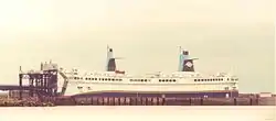 Roll-on/roll-off ferry MV Abegweit at Cape Tormentine
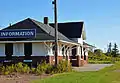 Former train station and lighthouse at Cape Tormentine
See also
References
- List of Lights, Pub. 110: Greenland, The East Coasts of North and South America (Excluding Continental U.S.A. Except the East Coast of Florida) and the West Indies (PDF). List of Lights. United States National Geospatial-Intelligence Agency. 2015.
- Northern New Brunswick The Lighthouse Directory. University of North Carolina at Chapel Hill. Retrieved 25 February 2017
- List of Lights, Pub. 110: Greenland, The East Coasts of North and South America (Excluding Continental U.S.A. Except the East Coast of Florida) and the West Indies (PDF). List of Lights. United States National Geospatial-Intelligence Agency. 2016.
- "Cape Tormentine residents want derelict buildings removed". CBC. Retrieved 10 January 2016.
- "P.E.I.'s Coastal Vessels and Ferries". Retrieved 11 January 2016.
External links
- Aids to Navigation Canadian Coast Guard
This article is issued from Wikipedia. The text is licensed under Creative Commons - Attribution - Sharealike. Additional terms may apply for the media files.