Burgeo
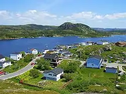
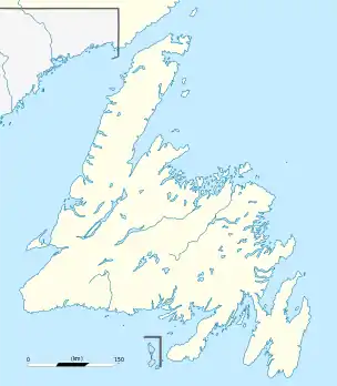
Burgeo (/ˈbɜːrdʒoʊ/ BUR-joh)[2] is a town in the Canadian province of Newfoundland and Labrador. It is located mainly on Grandy Island, on the south coast of the island of Newfoundland. It is an outport community.
Burgeo | |
|---|---|
Town | |
 | |
 Flag | |
 Burgeo Location of Burgeo in Newfoundland | |
| Coordinates: 47°36′00″N 57°38′00″W | |
| Country | |
| Province | |
| Government | |
| • Mayor | John Savoury |
| • MHA | Andrew Parsons (Burgeo and La Poile) |
| • MP | Gudie Hutchings (Long Range Mountains) |
| Population (2016) | |
| • Total | 1,307[1] |
| Time zone | UTC-3:30 (Newfoundland Time) |
| • Summer (DST) | UTC-2:30 (Newfoundland Daylight) |
| Area code(s) | 709 |
| Highways | |
 Aerial view of Burgeo Islands | |
The town is approximately 121 kilometres (75 mi) east of Channel-Port aux Basques. Burgeo is home to Sandbanks Provincial Park, named for its sand dunes and long expanses of flat, sandy beaches.[3]
Demographics
The population was 900 in 1911, 2,474 in 1976, 1,607 in 2006, 1,464 in 2011 and 1,307 in 2016.[1] The median age in the town was 57 in 2006.[4]
The principal industry was fishing and fish processing until the town was one of many affected by 1992 cod moratorium[5] which caused excessive outmigration.
Transport links
There is a ferry dock with connections to Ramea, Grey River and Francois. The town is also the southern terminus for Route 480 (Burgeo Highway), connecting Burgeo with the Trans-Canada Highway (Route 1) and the rest of mainland Newfoundland.[6]
Climate
| Climate data for Burgeo | |||||||||||||
|---|---|---|---|---|---|---|---|---|---|---|---|---|---|
| Month | Jan | Feb | Mar | Apr | May | Jun | Jul | Aug | Sep | Oct | Nov | Dec | Year |
| Record high °C (°F) | 8.7 (47.7) |
8.9 (48.0) |
9.2 (48.6) |
14.8 (58.6) |
21.7 (71.1) |
24.4 (75.9) |
25.9 (78.6) |
26.7 (80.1) |
23.1 (73.6) |
18.6 (65.5) |
14.4 (57.9) |
11.5 (52.7) |
26.7 (80.1) |
| Average high °C (°F) | −1.4 (29.5) |
−2 (28) |
0.5 (32.9) |
4.5 (40.1) |
8.8 (47.8) |
12.6 (54.7) |
16.5 (61.7) |
18.1 (64.6) |
15.2 (59.4) |
10.3 (50.5) |
5.8 (42.4) |
1.3 (34.3) |
7.5 (45.5) |
| Average low °C (°F) | −8.4 (16.9) |
−9.4 (15.1) |
−6.4 (20.5) |
−1.5 (29.3) |
2.4 (36.3) |
6.4 (43.5) |
10.5 (50.9) |
11.4 (52.5) |
7.8 (46.0) |
3.4 (38.1) |
−0.3 (31.5) |
−5.4 (22.3) |
0.9 (33.6) |
| Record low °C (°F) | −19.4 (−2.9) |
−25.6 (−14.1) |
−25.2 (−13.4) |
−12.2 (10.0) |
−7.2 (19.0) |
1.1 (34.0) |
4.4 (39.9) |
3.9 (39.0) |
−0.6 (30.9) |
−4.7 (23.5) |
−12.9 (8.8) |
−18.3 (−0.9) |
−25.6 (−14.1) |
| Average precipitation mm (inches) | 156.7 (6.17) |
130.5 (5.14) |
128.1 (5.04) |
131.6 (5.18) |
125.2 (4.93) |
149.3 (5.88) |
139.9 (5.51) |
138.5 (5.45) |
133.2 (5.24) |
156.9 (6.18) |
175.5 (6.91) |
173.8 (6.84) |
1,739.2 (68.47) |
| Source: 1961-1990 Environment Canada [8] | |||||||||||||
First Nations
Burgeo (Najioqonuk in Mi'kmaq) falls under the Flat Bay ward of the Qalipu First Nation.[9] It is also home to the independent Burgeo Band of Indians, a local band of Mi'kmaq that are currently non-status but are planning to seek status under the Indian Act.[10]
In popular culture
Burgeo appears as a playable area in the 2005 video game Club Penguin.
Notable people
The famed Canadian nature writer and naturalist Farley Mowat lived in Burgeo for five years during his time in Newfoundland. He wrote several books during his time there, including the controversial A Whale for the Killing,[11] which was later adapted into a movie loosely based on the book but with the same name. Mowat's wife, Claire Mowat, wrote her book The Outport People about life in Burgeo[12] although the town in the book is given the fictional name "Baleena".[13]
Route 480, also referred to as the Burgeo road, was a frequent subject for famed Canadian painter Christopher Pratt, who depicted it on several occasions and began his book Thoughts on Driving to Venus there in 1999. On Saturday April 11th (2009), Pratt wrote[14]:
‘Burgeo Road, 10:30 am. 3°C, breezy, mixture of sun and cloud. Enroute Sandbanks on a chilly but very inviting day. I always remember these "Car Books" began on this road—intended to be a short-hand, stream of consciousness, trigger-happy sort of thing, a sequence of responses, not considered efforts at insights or forced philosophies.'
See also
- List of cities and towns in Newfoundland and Labrador
- Burgeo-La Poile
References
- "Burgeo Census". Statistics Canada. Retrieved 30 June 2018.
- The Canadian Press Stylebook (18th ed.), Toronto: The Canadian Press, The Canadian Press, 2017
- "Sandbanks Provincial Park". Newfoundland and Labrador. Retrieved 15 May 2019.
- "Burgeo Profile - Community Accounts". nl.communityaccounts.ca. Retrieved 26 November 2020.
- "Burgeo | The Canadian Encyclopedia". www.thecanadianencyclopedia.ca. Retrieved 26 November 2020.
- "Burgeo". Town of Burgeo. Retrieved 17 March 2018.
- Canada, Environment and Climate Change (9 February 2011). "Canadian Climate Normals 1961-1990 Station Data - Climate - Environment and Climate Change Canada". climate.weather.gc.ca. Retrieved 8 June 2020.
- Environment Canada—Canadian Climate Normals 1961–1990. Retrieved 7 October 2012.
- "Qalipu First Nation", Wikipedia, 2 December 2020, retrieved 3 December 2020
- "Burgeo Mi'kmaq split off to form Newfoundland's newest Aboriginal band | CBC News". CBC. Retrieved 3 December 2020.
- "Farley Mowat remembered by Burgeo resident | CBC News". CBC. Retrieved 26 November 2020.
- "Claire Mowat, Farley's Boswell". Retrieved 26 November 2020.
- "CM Archive". www.cmreviews.ca. Retrieved 26 November 2020.
- "The Porcupine's Quill | Book Listing | Thoughts on Driving to Venus". porcupinesquill.ca. Retrieved 18 August 2020.
External links
| Wikivoyage has a travel guide for Burgeo. |
| Census divisions | |
|---|---|
| Cities | |
| Other communities |
|
| |
