Tuzigoot National Monument
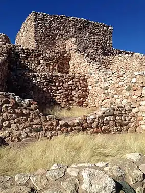
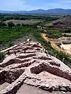
Tuzigoot National Monument (Yavapai: ʼHaktlakva, Western Apache: Tú Digiz) preserves a 2- to 3-story pueblo ruin on the summit of a limestone and sandstone ridge just east of Clarkdale, Arizona, 120 feet (36 m) above the Verde River floodplain. The Tuzigoot Site is an elongated complex of stone masonry rooms that were built along the spine of a natural outcrop in the Verde Valley. The central rooms stand higher than the others and they appear to have served public functions.[3] The pueblo has 110 rooms.[4] The National Park Service currently administers 58 acres (23 ha), within an authorized boundary of 834 acres (338 ha).[5]
| Tuzigoot National Monument | |
|---|---|
IUCN category III (natural monument or feature) | |
 Part of the Tuzigoot pueblo | |
  | |
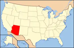
| Location | Yavapai County, Arizona, USA |
| Nearest city | Cottonwood, Arizona |
| Coordinates | 34.7708537°N 112.0259912°W |
| Area | 811.89 acres (328.56 ha)[1] |
| Created | July 25, 1939 |
| Visitors | 98,090 (in 2018)[2] |
| Governing body | National Park Service |
| Website | Tuzigoot National Monument |
″Tú Digiz/Tuzigoot″ is a Tonto Apache term for "crooked waters,"[6] from nearby Pecks Lake, a cutoff meander of the Verde River; from Tú Digiz one principal Tonto Apache clan gets its name. The pueblo was built by the Sinagua people between 1125 and 1400 CE. Tuzigoot is the largest and best preserved of the many Sinagua pueblo ruins in the Verde Valley. The ruins at Tuzigoot incorporate very few doors; instead, the inhabitants used ladders accessed by trapdoor type openings in the roofs to enter each room.
The monument is on land once owned by United Verde/Phelps Dodge. The corporation sold the site to Yavapai County for $1 so that the excavation could be completed under the auspices of federal relief projects. The county in turn transferred the land to the federal government.[7]
Tuzigoot was excavated from 1933 to 1935 by Louis Caywood and Edward Spicer of the University of Arizona, with funding from the federal Civil Works Administration and Works Project Administration. In 1935–1936, with additional federal funding, the ruins were prepared for public display, and a Pueblo Revival-style museum and visitor center was constructed.
Franklin D. Roosevelt designated Tuzigoot Ruins as a U.S. National Monument on July 25, 1939.[8] The Tuzigoot National Monument Archeological District was listed on the National Register of Historic Places on October 15, 1966.[9][10]
The ruins are surrounded by the tailings pond of the former United Verde copper mine at Jerome. The tailings have recently been stabilized and revegetated.[11]
Gallery
 Tuzigoot National Monument
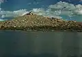 Tuzigoot, viewed from across the old tailings pond, 1945
.jpg.webp) Tuzigoot Museum
Tuzigoot Museum
See also
References
- "Listing of acreage as of December 31, 2011". Land Resource Division, National Park Service. Retrieved 2012-05-14.
- "NPS Annual Recreation Visits Report". National Park Service. Retrieved 2019-06-15.
- Archaeology of Native North America, 2010, Dean R. Snow, Prentice-Hall, New York. pp. 134
- "Tuzigoot History & Culture". National Park Service.
- "Tuzigoot Nature & Science". National Park Service.
- "Frequently Asked Questions". National Park Service. March 31, 2012. Retrieved August 31, 2017.
- "Tuzigoot National Monument". Yavapai Heritage Roundup. Archived from the original on 2007-09-28.
- "Tuzigoot Celebrates Its 70th Birthday" (PDF). National Park Service. July 16, 2009.
- "National Register Information System". National Register of Historic Places. National Park Service. November 15, 1966.
- Kaiser, Harvey H. (2003). An Architectural Guide to the Southwest National Parks. Salt Lake City: Gibbs-Smith. ISBN 1-58685-068-7.
- "Tailings soon a thing of the past". Verde Independent. 2006-06-14. Archived from the original on 2007-08-06.
External links
| Wikimedia Commons has media related to Tuzigoot National Monument. |
- "Tuzigoot National Monument". National Park Service.
- "Tuzigoot National Monument, Arizona". Archeology Program. National Park Service.
- "Tuzigoot National Monument". National Register of Historic Places Travel Itinerary. National Park Service.
- "Montezuma Castle Tuzigoot National Monuments: General Management Plan/Environmental Assessment Summary". National Park Service.
 | |||
| Authority control |
|---|