Clair Parish, New Brunswick
Clair is a civil parish in Madawaska County, New Brunswick, Canada.[2]
Clair | |
|---|---|
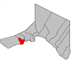 Location within Madawaska County. | |
| Coordinates: 47.295°N 68.67°W | |
| Country | |
| Province | |
| County | Madawaska |
| Erected | 1900 |
| Area | |
| • Land | 43.92 km2 (16.96 sq mi) |
| Population (2016)[1] | |
| • Total | 283 |
| • Density | 6.4/km2 (17/sq mi) |
| • Change 2011-2016 | |
| • Dwellings | 101 |
| Time zone | UTC-4 (AST) |
| • Summer (DST) | UTC-3 (ADT) |
For governance purposes it is part of the incorporated rural community of Haut-Madawaska,[3] which is a member of the Northwest Regional Service Commission (NWRSC).[4]
Origin of name
Clair was named in honour of Peter Clair, an early immigrant from County Clare, Ireland.[5]
History
Clair was erected in 1900 from Saint-François.[6]
In 1912 Lac Baker Parish was erected from part of Clair;[7] the boundary was slightly altered later that year.[8]
Clair was affected by the major reorganisation of Madawaska County parish boundaries in 1946.[9]
Delineation
Clair Parish is defined in the Territorial Division Act[2] as being bounded:
- Beginning in the International Boundary at a point where it is intersected by the southern prolongation of the east limit of lot No. 9 Range Two granted to Joseph Nadeau thence along the said prolongation, said limit and its northern prolongation to the northern limit of Range Three north of the St. John River, thence in a westerly direction along said northern limit to a point where it is intersected by the western limit of Range Five west of Baker Lake, thence in a northwesterly direction along said limit to the northwest angle of lot No. 26 in said Range Five, thence northeasterly along the northern limit of last mentioned lot to the west limit of Range Four thence northwesterly along last mentioned limit to the northwest angle of lot No. 43 in Range Four, thence, northeasterly along the northern limit of said lot No. 43 to the west limit of Range Three thence northwesterly along said limit or to the northwest angle of lot No. 42 in Range Three thence in a northeasterly direction along the north west limit of said lot No. 42 to the west limit of Range Two, thence southeasterly along said west limit of said Range Two to the west limit of lots in the Second Tier west of Caron Brook thence along the said western limit to the northwest angle of lot No. 15 granted to Joseph Souci and thence easterly along the north limit of said lot No. 15, lot Letter "I" granted to George Carriveau and the northern limit of the lots fronting on the St. John River to the northwest angle of lot No. 83 granted to Augustine Daigle, thence in a southerly direction along the west limit of said lot No. 83 and its southern prolongation to the International Boundary, thence westerly along the said International Boundary to the place of beginning.
Communities
Parish population total does not include incorporated municipalities (in bold) and communities within their respective boundaries (in italics).
- Caron Brook
- Clair
- Concession-des-Lang
- Concession-des-Vasseur
- Crockett
- Les Rapides
Bodies of water
Bodies of water at least partly in the parish
- Saint John River
Demographics
Population
| Canada census – Clair Parish, New Brunswick community profile | |||
|---|---|---|---|
| 2016 | 2011 | 2006 | |
| Population: | 283 (-4.7% from 2011) | 297 (+5.3% from 2006) | 282 (-2.4% from 2001) |
| Land area: | 43.92 km2 (16.96 sq mi) | 44.18 km2 (17.06 sq mi) | 44.29 km2 (17.10 sq mi) |
| Population density: | 6.4/km2 (17/sq mi) | 6.7/km2 (17/sq mi) | 6.4/km2 (17/sq mi) |
| Median age: | 51.1 (M: 52.0, F: 50.2) | 50.1 (M: 50.0, F: 50.2) | 43.2 (M: 42.5, F: 43.5) |
| Total private dwellings: | 101 | 121 | 114 |
| Median household income: | $65,088 | $102,983 | $77,294 |
| References: 2016[10] 2011[11] 2006[12] earlier[13] | |||
|
|
| |||||||||||||||||||||||||||
| [14][1] | |||||||||||||||||||||||||||||
Language
| Canada Census Mother Tongue - Clair Parish, New Brunswick[14][1] | ||||||||||||||||||
|---|---|---|---|---|---|---|---|---|---|---|---|---|---|---|---|---|---|---|
| Census | Total | French |
English |
French & English |
Other | |||||||||||||
| Year | Responses | Count | Trend | Pop % | Count | Trend | Pop % | Count | Trend | Pop % | Count | Trend | Pop % | |||||
2016 |
270 |
245 | 90.7% | 20 | 7.4% | 5 | 1.9% | 0 | 0% | |||||||||
2011 |
280 |
250 | 89.29% | 25 | 8.93% | 5 | 1.78% | 0 | 0.00% | |||||||||
2006 |
285 |
220 | 77.19% | 50 | 17.54% | 15 | 5.26% | 0 | 0.00% | |||||||||
2001 |
290 |
270 | 93.10% | 10 | 3.45% | 10 | 3.45% | 0 | 0.00% | |||||||||
1996 |
310 |
295 | n/a | 95.16% | 15 | n/a | 4.84% | 0 | n/a | 0.00% | 0 | n/a | 0.00% | |||||
See also
References
- "Census Profile, 2016 Census: Clair, Parish [Census subdivision], New Brunswick". Statistics Canada. Retrieved September 23, 2019.
- "Chapter T-3 Territorial Division Act". Government of New Brunswick. Retrieved 13 November 2020.
- "New Brunswick Regulation 2017-3 under the Municipalities Act (O.C. 2017-52)". Government of New Brunswick. Retrieved 19 July 2020.
- "Communities in each of the 12 Regional Service Commissions (RSC) / Les communautés dans chacune des 12 Commissions de services régionaux (CSR)" (PDF), Government of New Brunswick, July 2017, retrieved 2 February 2021
- "Clair Parish". Provincial Archives of New Brunswick. Retrieved 26 October 2020.
- "63 Vic. c. 18 An Act to amend an Act intituled 'An Act to revise and codify an Act to provide for the division of the Province into Counties, Towns and Parishes, so far as relates to the County of Madawaska.'". Acts of the General Assembly of Her Majesty's Province of New Brunswick. Passed in the Months of March and April, 1900. Fredericton: Government of New Brunswick. 1900. pp. 97–100.
- "1 Geo. V c. 46 An Act to amend Chapter 2 of The Consolidated Statutes, 1903, respecting the Division of the Province into Counties, Towns and Parishes, so far as relates to the County of Madawaska.". Acts of the Legislative Assembly of New Brunswick Passed in the Month of April, 1911. Fredericton: Government of New Brunswick. 1911. pp. 167–170.
- "2 Geo. V c. 16 An Act to amend Chapter 2 of the Consolidated Statutes, 1903, respecting the Division of the Province into Counties, Towns and Parishes, so far as relates to the County of Madawaska.". New Brunswick Acts of the Legislative Assembly Passed in the Months of March and April, 1912. Fredericton: Government of New Brunswick. 1912. pp. 131–132.
- "10 Geo. VI. c. 95 An Act to amend Chapter 2 of the Revised Statutes, 1927, respecting the division of the Province into Counties, Towns and Parishes, in so far as it relates to the County of Madawaska.". Acts of the Legislative Assembly of New Brunswick Passed During the Session of 1946. Fredericton: Government of New Brunswick. 1946. pp. 321–339.
- "2016 Community Profiles". 2016 Canadian Census. Statistics Canada. February 21, 2017. Retrieved 2019-09-23.
- "2011 Community Profiles". 2011 Canadian Census. Statistics Canada. July 5, 2013. Retrieved 2014-03-22.
- "2006 Community Profiles". 2006 Canadian Census. Statistics Canada. March 30, 2011. Retrieved 2014-03-22.
- "2001 Community Profiles". 2001 Canadian Census. Statistics Canada. February 17, 2012.
- Statistics Canada: 1996, 2001, 2006, 2011 census
Places adjacent to Clair Parish, New Brunswick | |
|---|---|
| Subdivisions | |
|---|---|
| Cities | |
| Counties | |
| |