Saint-François Parish, New Brunswick
Saint-François is a civil parish in Madawaska County, New Brunswick, Canada.[2]
Saint-François
St. Francis | |
|---|---|
 | |
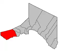 Location within Madawaska County. | |
| Coordinates: 47.27°N 68.92°W | |
| Country | |
| Province | |
| County | Madawaska |
| Erected | 1850 |
| Area | |
| • Land | 344.59 km2 (133.05 sq mi) |
| Population (2016)[1] | |
| • Total | 606 |
| • Density | 1.8/km2 (5/sq mi) |
| • Pop 2011-2016 | |
| • Dwellings | 347 |
| Time zone | UTC-4 (AST) |
| • Summer (DST) | UTC-3 (ADT) |
For governance purposes it is part of the incorporated rural community of Haut-Madawaska,[3] which is a member of the Northwest Regional Service Commission (NWRSC).[4]
Origin of name
The parish takes its name from the St. Francis River.[5]
History
Saint-François was erected as Saint Francis in 1850 from Madawaska Parish.[6]
In 1852 the parish was expanded northward to include territory award in the boundary settlement with Canada.[7]
In 1877 the eastern part of Saint-François was included in the newly erected Saint-Hilaire Parish.[8]
In 1900 Clair Parish was erected from the eastern part of Saint-François.[9]
In 1946 the name was changed to Saint Francois and the boundaries were affected by the major reorginsation of Madawaska County parish lines.[10]
In 1973 the name was changed to Saint-François.[11]
Delineation
Saint-François Parish is defined in the Territorial Division Act[2] as being bounded:
- Beginning in the International Boundary at a point where it is intersected by the southern prolongation of the east limit of lot No. 9, Range Two, granted to Joseph Nadeau thence along said prolongation, said limit and its northern prolongation to the northern limit of Range Three north of the St. John River thence in a westerly direction along said northern limit to a point where it is intersected by the western limit of Range Five west of Baker Lake thence in a northwesterly direction along said limit to the northwest angle of lot No. 26 in said Range Five thence northeasterly along the northern limit of last-mentioned lot to the west limit of Range Four thence northwesterly along last-mentioned limit to the northwest angle of lot No. 43 in said Range Four thence northeasterly along the northern limit of said lot No. 43 to the west limit of Range Three thence northwesterly along said limit of Range Three and its prolongation to the New Brunswick-Quebec Boundary line thence in a westerly direction following the New Brunswick-Quebec Boundary to the International Boundary thence in a southerly and easterly direction following said International Boundary to the place of beginning.
Communities
Parish population total does not include incorporated municipalities (in bold) and communities within their respective boundaries (in italics).
|
|
Bodies of water
Bodies of water at least partly in the parish
- Saint John River
Demographics
Population
| Canada census – Saint-François Parish, New Brunswick community profile | |||
|---|---|---|---|
| 2016 | 2011 | 2006 | |
| Population: | 606 (-3.8% from 2011) | 630 (-16.4% from 2006) | 754 (-12.1% from 2001) |
| Land area: | 344.59 km2 (133.05 sq mi) | 344.70 km2 (133.09 sq mi) | 344.70 km2 (133.09 sq mi) |
| Population density: | 1.8/km2 (4.7/sq mi) | 1.8/km2 (4.7/sq mi) | 2.2/km2 (5.7/sq mi) |
| Median age: | 49.8 (M: 50.8, F: 48.8) | 47.0 (M: 47.0, F: 47.0) | 42.3 (M: 42.1, F: 42.6) |
| Total private dwellings: | 347 | 309 | 432 |
| Median household income: | $60,096 | $.N/A | $47,460 |
| Notes: 2011 income data for this area has been suppressed for data quality or confidentiality reasons. – References: 2016[12] 2011[13] 2006[14] earlier[15] | |||
|
|
| |||||||||||||||||||||||||||
| [16][1] | |||||||||||||||||||||||||||||
Language
| Canada Census Mother Tongue - Saint-François Parish, New Brunswick[16] | ||||||||||||||||||
|---|---|---|---|---|---|---|---|---|---|---|---|---|---|---|---|---|---|---|
| Census | Total | French |
English |
French & English |
Other | |||||||||||||
| Year | Responses | Count | Trend | Pop % | Count | Trend | Pop % | Count | Trend | Pop % | Count | Trend | Pop % | |||||
2011 |
630 |
580 | 92.06% | 45 | 7.14% | 5 | 0.79% | 0 | 0.00% | |||||||||
2006 |
745 |
690 | 92.62% | 40 | 5.37% | 15 | 2.01% | 0 | 0.00% | |||||||||
2001 |
855 |
785 | 91.81% | 70 | 8.19% | 0 | 0.00% | 0 | 0.00% | |||||||||
1996 |
905 |
820 | n/a | 90.61% | 60 | n/a | 6.63% | 25 | n/a | 2.76% | 0 | n/a | 0.00% | |||||
See also
- Crocs River, a stream
- List of parishes in New Brunswick
References
- "Census Profile, 2016 Census: Saint-François, Parish [Census subdivision], New Brunswick". Statistics Canada. Retrieved August 29, 2019.
- "Chapter T-3 Territorial Division Act". Government of New Brunswick. Retrieved 13 November 2020.
- "New Brunswick Regulation 2017-3 under the Municipalities Act (O.C. 2017-52)". Government of New Brunswick. Retrieved 19 July 2020.
- "Communities in each of the 12 Regional Service Commissions (RSC) / Les communautés dans chacune des 12 Commissions de services régionaux (CSR)" (PDF), Government of New Brunswick, July 2017, retrieved 2 February 2021
- Ganong, William F. (1896). A Monograph of the Place-Nomenclature of the Province of New Brunswick. Royal Society of Canada. p. 268.
- "13 Vic. c. 51 An Act to consolidate all the Laws now in force for the division of the Province into Counties, Towns and Parishes.". Acts of the General Assembly of Her Mjaesty's Province of New Brunswick, Passed in the Year 1850. Fredericton: Government of New Brunswick. 1850. pp. 142–152, 145–149. Book was poorly proofread, resulting in title typo and reuse of page numbers 145–152.
- "15 Vic. c. 6 An Act to annex the Territory awarded to this Province by the New Brunswick and Canadian Arbitrators in the recent settlement of the Boundary question between the Provinces of New Brunswick and Canada, to the Counties of Victoria and Restigouche, and to alter the present Boundary Line between these counties.". Acts of the General Assembly of Her Majesty's Province of New Brunswick, Passed in the Year 1852. Fredericton: Government of New Brunswick. 1852. pp. 4–5.
- "41 Vic. c. 30 An Act to erect parts of the Parishes of Saint Leonard, Saint Basil, Madawaska, and Saint Francis, in the County of Madawaska, into three additional Parishes.". Acts of the General Assembly of Her Majesty's Province of New Brunswick. Passed in the Month of March 1877. Fredericton: Government of New Brunswick. 1877. pp. 125–128.
- "63 Vic. c. 18 An Act to amend an Act intituled 'An Act to revise and codify an Act to provide for the division of the Province into Counties, Towns and Parishes, so far as relates to the County of Madawaska.'". Acts of the General Assembly of Her Majesty's Province of New Brunswick. Passed in the Months of March and April, 1900. Fredericton: Government of New Brunswick. 1900. pp. 97–100.
- "10 Geo. VI. c. 95 An Act to amend Chapter 2 of the Revised Statutes, 1927, respecting the division of the Province into Counties, Towns and Parishes, in so far as it relates to the County of Madawaska.". Acts of the Legislative Assembly of New Brunswick Passed During the Session of 1946. Fredericton: Government of New Brunswick. 1946. pp. 321–339.
- "Chapter T-3 Territorial Division Act". Revised Statutes of New Brunswick 1973 Volume IV. Fredericton: Government of New Brunswick. 1973. pp. 1–70. The original printed version is cited separately to distinguish it from the updated version available online.
- "2016 Community Profiles". 2016 Canadian Census. Statistics Canada. February 21, 2017. Retrieved 2019-08-29.
- "2011 Community Profiles". 2011 Canadian Census. Statistics Canada. July 5, 2013. Retrieved 2014-03-21.
- "2006 Community Profiles". 2006 Canadian Census. Statistics Canada. March 30, 2011. Retrieved 2014-03-21.
- "2001 Community Profiles". 2001 Canadian Census. Statistics Canada. February 17, 2012.
- Statistics Canada: 1996, 2001, 2006, 2011 census
Places adjacent to Saint-François Parish, New Brunswick | |
|---|---|
| Subdivisions | |
|---|---|
| Cities | |
| Counties | |
| |
