Copper, Jackson County, Oregon
Copper is a former community in Jackson County, Oregon, United States.[1] Copper was located about 1 mile (1.6 km) north of the Oregon–California border, near the mouth of Carberry Creek.[2] Copper was named for the copper mining in the region, including at the Blue Ledge mine just over the state line in California.[2] The town had a post office from 1924 until 1932.[2] The elevation of Copper is 1,949 feet.
Copper, Jackson County, Oregon | |
|---|---|
 Copper  Copper | |
| Coordinates: 42°1′35″N 123°8′48″W | |
| Country | United States |
| State | Oregon |
| County | Jackson |
| Time zone | UTC-8 (Pacific (PST)) |
| • Summer (DST) | UTC-7 (PDT) |
| GNIS feature ID | 1140097[1] |
The townsite was inundated in 1980 when Applegate Lake was formed by damming the Applegate River.[3]
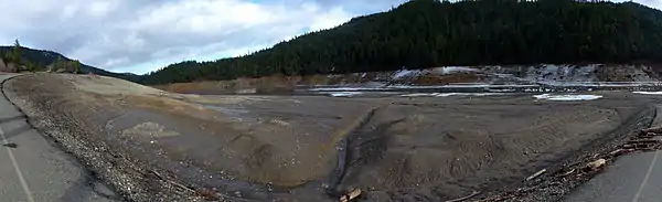
Mud flats at the south end of Applegate Lake where the town of Copper formerly stood. This area is usually submerged beneath over 60 feet (18 m) of water. The road, now a boat ramp, is the remains of the highway that once served Copper.
References
- "Copper". Geographic Names Information System. United States Geological Survey. November 28, 1980. Retrieved May 3, 2009.
- McArthur, Lewis A.; Lewis L. McArthur (2003) [1928]. Oregon Geographic Names (Seventh ed.). Portland, Oregon: Oregon Historical Society Press. p. 229. ISBN 978-0-87595-277-2.
- Miller, Bill (December 14, 2008). "The underwater ghost town". Mail Tribune. Retrieved December 19, 2008.
Municipalities and communities of Jackson County, Oregon, United States | ||
|---|---|---|
| Cities | 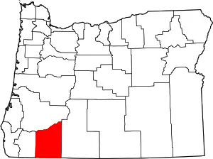 Jackson County map | |
| CDPs | ||
| Other unincorporated communities | ||
| Ghost towns | ||
| ||
| Authority control |
|---|
This article is issued from Wikipedia. The text is licensed under Creative Commons - Attribution - Sharealike. Additional terms may apply for the media files.