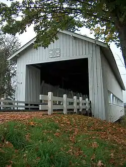
Crawfordsville Bridge
The Crawfordsville Bridge spans the Calapooia River adjacent to Oregon Route 228 near the community of Crawfordsville in Linn County, Oregon, United States.[2]
Crawfordsville Bridge | |
 The Crawfordsville Covered Bridge crosses the Calapooia River | |
  | |
| Location | SR 228, Crawfordsville, Oregon |
|---|---|
| Coordinates | 44°21′28″N 122°51′32″W |
| Area | 0.2 acres (0.081 ha) |
| Built | 1932 |
| Architectural style | Howe Truss |
| MPS | Oregon Covered Bridges TR |
| NRHP reference No. | 79002115[1] |
| Added to NRHP | November 29, 1979 |
The 105-foot Howe truss type bridge was built in 1932. The bridge was bypassed in 1963 and is now maintained by the Linn County Parks & Recreation Department as a pedestrian bridge across the river. Since 1990, the bridge has been the site of a Bridge Day festival held annually in the summer.[3] A small park next to the bridge includes a picnic table and fire pit.[2]
The bridge was featured in the 1976 television movie The Flood.[4]
The bridge is listed on the National Register of Historic Places.[5]
References
- "National Register Information System". National Register of Historic Places. National Park Service. July 9, 2010.
- "Linn County Parks & Recreation - Crawfordsville Covered Bridge Wayside". Archived from the original on May 27, 2012. Retrieved February 20, 2012.
- "Homecoming, bridge day slated in Crawfordsville". democratherald.com. August 16, 2010. Retrieved February 20, 2012.
- "Calapooia River (Crawfordsville)" (PDF). www.oregon.gov. Retrieved February 20, 2012.
- "Oregon National Register List" (PDF). Oregon Parks and Recreation Department. June 6, 2011. Retrieved February 21, 2012.
External links
 Media related to Crawfordsville Bridge at Wikimedia Commons
This article is issued from Wikipedia. The text is licensed under Creative Commons - Attribution - Sharealike. Additional terms may apply for the media files.