Daro District
The Daro District is a district and small town in Mukah Division, Sarawak, Malaysia. The nearest town to Daro is Matu. Daro is under the Majlis Daerah Matu-Daro (Matu-Daro District Council) which share the same council together with Matu. The population in Daro is estimated around 25,000, with Melanau making up the majority. There were ferries from Sibu to here, taking around two hours by using the channel of Rejang River.
Daro District | |
|---|---|
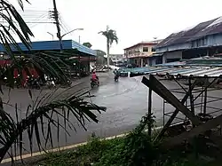 Daro town as seen in February 2015. | |
 Daro District | |
| Coordinates: 2°31′0″N 111°26′0″E | |
| Country | |
| State | |
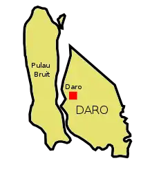
Map of Daro District
Education
Secondary school
- SMK Toh Puan Datuk Patinggi Hajjah Normah, Daro
- SMK Matu
- SMK Belawai
- SMK SEMOP
Primary school
1. SJK (C) Chung Hua 2. SK Campuran 3. SK Hijrah Badong 4. SK Nangar 5. SK Ulu Daro 6. SK Pangtray 7. SK Semop
Climate
Daro has a tropical rainforest climate (Af) with heavy to very heavy rainfall year-round.
| Climate data for Daro | |||||||||||||
|---|---|---|---|---|---|---|---|---|---|---|---|---|---|
| Month | Jan | Feb | Mar | Apr | May | Jun | Jul | Aug | Sep | Oct | Nov | Dec | Year |
| Average high °C (°F) | 30.1 (86.2) |
30.3 (86.5) |
31.3 (88.3) |
32.1 (89.8) |
32.6 (90.7) |
32.3 (90.1) |
32.2 (90.0) |
31.9 (89.4) |
31.8 (89.2) |
31.5 (88.7) |
31.4 (88.5) |
30.7 (87.3) |
31.5 (88.7) |
| Daily mean °C (°F) | 26.2 (79.2) |
26.3 (79.3) |
27.0 (80.6) |
27.4 (81.3) |
27.9 (82.2) |
27.5 (81.5) |
27.3 (81.1) |
27.1 (80.8) |
27.2 (81.0) |
27.0 (80.6) |
27.0 (80.6) |
26.5 (79.7) |
27.0 (80.7) |
| Average low °C (°F) | 22.4 (72.3) |
22.4 (72.3) |
22.8 (73.0) |
22.8 (73.0) |
23.2 (73.8) |
22.8 (73.0) |
22.4 (72.3) |
22.4 (72.3) |
22.6 (72.7) |
22.6 (72.7) |
22.6 (72.7) |
22.4 (72.3) |
22.6 (72.7) |
| Average rainfall mm (inches) | 432 (17.0) |
252 (9.9) |
215 (8.5) |
179 (7.0) |
165 (6.5) |
204 (8.0) |
164 (6.5) |
162 (6.4) |
153 (6.0) |
244 (9.6) |
288 (11.3) |
360 (14.2) |
2,818 (110.9) |
| Source: Climate-Data.org[1] | |||||||||||||
References
- "Climate: Daro". Climate-Data.org. Retrieved 29 October 2020.
External links
Capital: Kuching | |
| History | |
| Topics |
|
| Society |
|
| Administrative divisions | |
| |
This article is issued from Wikipedia. The text is licensed under Creative Commons - Attribution - Sharealike. Additional terms may apply for the media files.
