District Heights, Maryland
District Heights is an incorporated city in Prince George's County, Maryland, United States, located near Maryland Route 4.[5] The population was 5,837 at the 2010 United States Census. For more information, see the separate articles on Forestville and Suitland.
District Heights, Maryland | |
|---|---|
| City of District Heights | |
 Seal | |
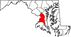
 Location of District Heights, Maryland | |
| Coordinates: 38°51′34″N 76°53′21″W | |
| Country | |
| State | |
| County | |
| Incorporated | 1936[1] |
| Area | |
| • Total | 0.86 sq mi (2.24 km2) |
| • Land | 0.86 sq mi (2.24 km2) |
| • Water | 0.00 sq mi (0.00 km2) |
| Elevation | 266 ft (81 m) |
| Population | |
| • Total | 5,837 |
| • Estimate (2019)[4] | 5,984 |
| • Density | 6,917.92/sq mi (2,670.91/km2) |
| Time zone | UTC-5 (EST) |
| • Summer (DST) | UTC-4 (EDT) |
| ZIP codes | 20747, 20753 |
| Area code(s) | 301 |
| FIPS code | 24-23025 |
| GNIS feature ID | 0597330 |
| Website | http://www.districtheights.org/ |
District Heights is located 9.85 miles (15.85 km) from central Washington.
Geography
District Heights is located at 38°51′34″N 76°53′21″W (38.859545, −76.889139).[6]
According to the United States Census Bureau, the city has a total area of 0.93 square miles (2.41 km2), all land.[7]
History
District Heights was originally farmland owned by Major Leander P. Williams, purchased as four patented Lord Baltimore tracts known as: "Good Luck," "Magruder's Plains Enlarged," "the Levels," and "Offutt's Adventure." Under grants issued to Lord Baltimore by King Charles I of Great Britain, the tracts belonged to Colonel Ninian Beall, Benjamin Berry, and Alexander Magruder. District Heights evolved from one of the four patents. In 1925, land was purchased and formed into District Heights Company by Joseph Tepper, David L. Blanken, Henry Oxenberg, Gilbert Leventhal, Simon Gordon, and Simon Gerber. The land was farmed by Walter and Al Dustin, whose farmhouse stood at 7116 Foster Street. By 1925, streets laid out first three blocks of Halleck Street and Aztec. By 1936, the city had approximately 25 homes built, two businesses, a grocery store and filling station, a pump house and water tower to furnish the water and pressure for the City, a sewage system and a free Model T bus service to 17th and Pennsylvania Avenue, S.E.
Adjacent areas
- Walker Mill (north)
- Forestville (southeast)
- Capitol Heights (northwest)
- Morningside (south)
Demographics
| Historical population | |||
|---|---|---|---|
| Census | Pop. | %± | |
| 1940 | 32 | — | |
| 1950 | 1,735 | 5,321.9% | |
| 1960 | 7,524 | 333.7% | |
| 1970 | 7,846 | 4.3% | |
| 1980 | 6,799 | −13.3% | |
| 1990 | 6,704 | −1.4% | |
| 2000 | 5,958 | −11.1% | |
| 2010 | 5,837 | −2.0% | |
| 2019 (est.) | 5,984 | [4] | 2.5% |
| U.S. Decennial Census[8] | |||
2010 census
As of the census[3] of 2010, there were 5,837 people, 2,050 households, and 1,505 families residing in the city. The population density was 6,276.3 inhabitants per square mile (2,423.3/km2). There were 2,212 housing units at an average density of 2,378.5 per square mile (918.3/km2). The racial makeup of the city was 6.0% White, 90.1% African American, 0.2% Native American, 0.6% Asian, 1.1% from other races, and 1.9% from two or more races. Hispanic or Latino of any race were 3.7% of the population.
There were 2,050 households, of which 40.4% had children under the age of 18 living with them, 35.0% were married couples living together, 32.8% had a female householder with no husband present, 5.7% had a male householder with no wife present, and 26.6% were non-families. 22.5% of all households were made up of individuals, and 5.7% had someone living alone who was 65 years of age or older. The average household size was 2.85 and the average family size was 3.31.
The median age in the city was 35.8 years. 26.3% of residents were under the age of 18; 10.9% were between the ages of 18 and 24; 24.5% were from 25 to 44; 28.3% were from 45 to 64; and 10% were 65 years of age or older. The gender makeup of the city was 46.0% male and 54.0% female.
2000 census
As of the census[9] of 2000, there were 5,958 people, 2,070 households, and 1,538 families residing in the city. The population density was 6,649.1 people per square mile (2,556.0/km2). There were 2,170 housing units at an average density of 2,421.7 per square mile (930.9/km2). The racial makeup of the city was 9.20% White, 87.95% African American, 0.12% Native American, 0.86% Asian, 0.20% from other races, and 1.68% from two or more races. Hispanic or Latino of any race were 0.49% of the population.
There were 2,070 households, out of which 38.3% had children under the age of 18 living with them, 39.6% were married couples living together, 28.2% had a female householder with no husband present, and 25.7% were non-families. 22.1% of all households were made up of individuals, and 5.0% had someone living alone who was 65 years of age or older. The average household size was 2.88 and the average family size was 3.36.
In the city, the population was spread out, with 30.8% under the age of 18, 8.3% from 18 to 24, 29.3% from 25 to 44, 23.6% from 45 to 64, and 8.0% who were 65 years of age or older. The median age was 34 years. For every 100 females, there were 84.9 males. For every 100 females age 18 and over, there were 76.1 males.
The median income for a household in the city was $52,331, and the median income for a family was $61,220. Males had a median income of $37,129 versus $32,443 for females. The per capita income for the city was $21,190. About 4.5% of families and 5.9% of the population were below the poverty line, including 9.0% of those under age 18 and 6.1% of those age 65 or over.
Notable people
- Lloyd R. Woodson, arrested in 2010 with military-grade illegal weapons he intended to use in a violent crime, and a detailed map of the Fort Drum military installation.[10]
- NaVorro Bowman, former outside linebacker at Penn State University and former inside linebacker for the San Francisco 49ers and Oakland Raiders was born and attended high school in Forestville.[11]
- East Coast Rapist, Aaron H. Thomas, lived in District Heights/Forestville from June 1994 to August 2006.
- LaTonya Swann, winner of BET's Born To Dance, was born and raised in District Heights.
Government
The city is governed by a mayor and city commission elected every 4 years. The current elected mayor and city commission are: Mayor Johnathan Medlock Commissioner Cynthia Miller (Ward 1); Commissioner (Vacant) - Ward 1 Commissioner Harryette Irving (Ward 2); Commissioner Carol M. Blake (Ward 2)[12]
In June 2019, Mayor Martin was charged with misdemeanor misconduct in office for helping a friend buy $50,000 in fireworks only available to cities and those with a federal explosive license by asserting on city letterhead that they were for the city's Fourth of July celebration rather than for private use.[13][14]
The U.S. Postal Service operates the District Heights Post Office in an unincorporated area next to the city limits.[15][16]
Law enforcement
The District Heights Police Department (DHPD) is the primary law enforcement agency for the City of District Heights which is located in Prince George's County, Maryland. An agreement exists with Prince George's County Police Department and the Prince George's County Sheriff's Office that outlines mutual aid assistance. Assistance is also provided by neighboring municipal agencies.[17]
Officers serve the City Commission and the citizens who reside in and around the Municipal Corporation of District Heights. District Heights is located within the 8th District of the Prince George's County Police Department. The two agencies work closely together responding to calls for service as well as solving crimes. Although the crime rate as reported by the Federal Bureau of Investigation is twenty~two percent higher than the national average, this number represents both the non-corporate and corporate portions of District Heights.
The District Heights Police Department began in 1936. Over the years, it has seen many different officers. In 2012, Chief Michael March (Ret) retired, sparking the City Commission to temporarily appoint Chief (Fmr) Yolanda Alexander. Chief Alexander served as acting Chief for more than a year until she was fully sworn in as Chief of Police in October 2013. Her contract as Chief for the District Heights Police Department was not renewed after May 2014 City Mayoral and Commission elections. Several members stated a difference of opinion. Chief Elliott Gibson, was hired in May 2014, as Police Chief. Chief Gibson had a long history and experience in law enforcement. He was terminated by the City Commission after new Commissioners were elected in May 2019. The police department was overseen by the District 8 Commander and Asst. Commander of the Prince George’s County Police Department until November of 2020 when Interim Chief Kinsey Weems was appointed. Chief Weems has been a member of the agency since 2013.
Prince George's County Police Department District 8 Station in Upper Marlboro CDP serves the community.[18]
Education
The city is served by the Prince George's County Public Schools and District 7 of the County's Board of Education.[15][19]
Elementary schools that serve the city include:[20]
- District Heights Elementary School[21]
- Formerly included District Heights Parkway Elementary, whose building makes up half the current school, and which fed primary grades to District Heights Elementary following 2nd or 3rd grade
- North Forestville Elementary School[22]
Middle schools that serve the city include:[23]
- Drew-Freeman Middle School (7-8)[24]
- Walker Mill Middle School
High schools that serve the city include:[25]
Francis Scott Key Elementary School is neither in the city, nor serves the city, but has a District Heights postal address.[28] The district previously operated Berkshire Elementary School in what is now Suitland CDP,[29][30] near District Heights. Berkshire Elementary closed in 2009.[31]
Public libraries
The Prince George's County Memorial Library System operates the Spauldings Branch Library near District Heights.[32]
Transportation
_just_south_of_Atwood_Street_and_Scott_Key_Drive_in_District_Heights%252C_Prince_George's_County%252C_Maryland.jpg.webp)
The only highway passing directly through District Heights is Maryland Route 458. MD 458 connects southwest to Maryland Route 5, which provides access to Washington, D.C. and Interstate 95/Interstate 495 (Capital Beltway).
References
- "District Heights". Maryland Manual. Retrieved 27 June 2017.
- "2019 U.S. Gazetteer Files". United States Census Bureau. Retrieved July 25, 2020.
- "U.S. Census website". United States Census Bureau. Retrieved 2013-01-25.
- "Population and Housing Unit Estimates". United States Census Bureau. May 24, 2020. Retrieved May 27, 2020.
- U.S. Geological Survey Geographic Names Information System: District Heights, Maryland
- "US Gazetteer files: 2010, 2000, and 1990". United States Census Bureau. 2011-02-12. Retrieved 2011-04-23.
- "US Gazetteer files 2010". United States Census Bureau. Archived from the original on 2012-07-02. Retrieved 2013-01-25.
- "Census of Population and Housing". Census.gov. Retrieved June 4, 2015.
- "U.S. Census website". United States Census Bureau. Retrieved 2008-01-31.
- Markon, Jerry (January 27, 2010). "FBI says no terrorism link for Reston man found with weapons". The Washington Post. Retrieved January 26, 2010.
- "Navorro Bowman". 247sports.com. CBS Interactive. Retrieved April 28, 2020.
- "City Commissioners". City Of District Heights. Retrieved June 17, 2019.
- Bui, Lynh (June 7, 2019). "Md. mayor says $50,000 in fireworks were for city, but prosecutors say they were for a friend". The Washington Post. Retrieved June 17, 2019.
- "Mayor in MD Faces Misconduct Charge Over Fireworks Purchase". NBC4 Washington. June 7, 2019. Retrieved June 17, 2019.
- "Boundary Map." District Heights, Maryland. Retrieved on March 1, 2018.
- "District Heights." U.S. Postal Service. Retrieved on August 29, 2018. "DISTRICT HEIGHTS 6514 MARLBORO PIKE DISTRICT HEIGHTS, MD 20747-9997"
- Demographics Archived May 14, 2008, at the Wayback Machine
- "Marlboro-118 District 8 Station - Upper Marlboro." Prince George's County Police Department. Retrieved on December 7, 2019. " 8903 Presidential Parkway Upper Marlboro, MD 20772 ". Beat map. See 2010 U.S. Census Map of Upper Marlboro CDP.
- "Prince George's County Public Schools Board of Education".
- "NEIGHBORHOOD ELEMENTARY SCHOOLS AND BOUNDARIES SCHOOL YEAR 2017-2018." Prince George's County Public Schools. Retrieved on January 31, 2018.
- "Archived copy". Archived from the original on 2007-09-06. Retrieved 2007-07-15.CS1 maint: archived copy as title (link)
- "Archived copy". Archived from the original on 2007-06-25. Retrieved 2007-07-15.CS1 maint: archived copy as title (link)
- "NEIGHBORHOOD MIDDLE SCHOOLS AND BOUNDARIES SCHOOL YEAR 2017-2018." Prince George's County Public Schools. Retrieved on January 31, 2018.
- "Archived copy". Archived from the original on 2007-07-17. Retrieved 2007-07-15.CS1 maint: archived copy as title (link)
- "NEIGHBORHOOD HIGH SCHOOLS AND BOUNDARIES SCHOOL YEAR 2017-2018." Prince George's County Public Schools. Retrieved on January 31, 2018.
- "Dr. Henry A. Wise, Jr. High School Home Page". www1.pgcps.org. Retrieved June 17, 2019.
- "Suitland High School". www1.pgcps.org. Retrieved June 17, 2019.
- Home. Francis Scott Key Elementary School. Retrieved on August 29, 2018. "Francis Scott Key Elementary 2301 Scott Key Drive District Heights, Maryland 20747"
- "Home." Berkshire Elementary School. February 22, 1999. Retrieved on August 29, 2019. "Berkshire Elementary School 6201 Surrey Square Lane District Heights, MD 20747"
- "2010 CENSUS - CENSUS BLOCK MAP (INDEX): Suitland CDP, MD." U.S. Census Bureau. Retrieved on August 29, 2018. Pages: 1 and 2.
- Wiggins, Ovetta (2014-06-30). "Barack Obama Elementary School principal in Prince George's County is transferred". Washington Post. Retrieved 2018-08-28.
- "Spauldings Branch." Prince George's County Memorial Library System. Retrieved on August 29, 2018. "Spauldings Branch 5811 Old Silver Hill Rd District Heights, MD 20747" - the location is not in the municipal limits.
External links
| Wikimedia Commons has media related to District Heights, Maryland. |
| State | .svg.png.webp) | |
|---|---|---|
| County departments | ||
| Municipal departments | ||
| Sheriff's offices | ||
| Universities | ||
| Authority control |
|---|