Tantallon, Maryland
Tantallon is an unincorporated community in Prince George's County, Maryland, United States. Although a separate community, it is a part of the census-designated place (CDP) of Fort Washington.[3] The ZIP code for the community is 20744. Tantallon reported as a census-designated place by the U.S. Census Bureau in 1980, which included much of the northern half of Fort Washington's census area.[4] The population recorded was 9,945.[5]
Tantallon | |
|---|---|
Unincorporated community and former Census-designated place (CDP) | |
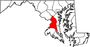
 Tantallon Location within the state of Maryland  Tantallon Tantallon (the United States) | |
| Coordinates: 38°43′26″N 77°1′00″W | |
| Country | United States |
| State | Maryland |
| County | Prince Georges |
| Elevation | 39 ft (12 m) |
| Population (1980) | |
| • Total | 9,945 |
| Time zone | UTC−5 (Eastern (EST)) |
| • Summer (DST) | UTC−4 (EDT) |
| ZIP codes | 20744 |
| FIPS code | 24-76825[1] |
| GNIS feature ID | 598151[2] |
Geography
Tantallon is located at 38.7 degrees north, 77.0 degrees west (38.724, −77.01);[6] or approximately 12 miles south-southeast of Washington, D.C..[7] The elevation for the community is 39 feet above sea level.[2]
Education
The community of Tantallon is served by the Prince George's County Public Schools system, which serves the entire county.
References
- Tantallon, Maryland Archived 2013-09-17 at Archive.today. Roadside Thoughts. Retrieved 2013-09-17.
- Tantallon - Maryland Gazetteer. Hometown Locator. Retrieved 2013-09-17.
- 1990 Census of Population - Maryland. United States Census Bureau. Retrieved 2013-07-19.
- 1980 census of population: part 1. United States Census Bureau. Retrieved 2913-09-17.
- County and city data book, Pages 1-416. 1983. Retrieved 2013-09-17.
- "US Gazetteer files: 2010, 2000, and 1990". United States Census Bureau. 2011-02-12. Retrieved 2011-04-23.
- Distance between Tantallon (Prince George's County,Maryland) and Washington (District of Columbia). Retrieved 2013-09-17.