Divide, Oregon
Divide is a ghost town in Lane County, Oregon, United States, located southwest of Cottage Grove, near Interstate 5.[1][2] A post office in Douglas County near a train station on the Southern Pacific Railroad was established on May 31, 1900, and it was closed on January 15, 1921. In 1909, the post office was relisted as a Lane County post office. It may have been moved across county borders, or its county may have changed during a shift in the border between Lane and Douglas counties.[2]
Divide, Oregon | |
|---|---|
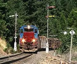 A train passing by Divide | |
 Divide  Divide | |
| Coordinates: 43°45′04″N 123°07′11″W | |
| Country | United States |
| State | Oregon |
| County | Lane |
| Established | 1900 |
| Elevation | 745 ft (227 m) |
| Time zone | UTC-8 (Pacific (PST)) |
| • Summer (DST) | UTC-7 (PDT) |
| Area code(s) | 458 and 541 |
| GNIS feature ID | 1119961 |
| Elevation and coordinates derived from the Geographic Names Information System[1] | |
Divide got its name because it is very near the boundary between the Umpqua River watershed on the west and the Willamette River watershed on the east. On the west side, water flows into Pass Creek, and the on the east side it flows into the Coast Fork Willamette River. Additionally, the southeast edges of the Siuslaw River watershed are immediately north of Divide.[1][2]
References
- "Divide". Geographic Names Information System. United States Geological Survey. November 28, 1980. Retrieved August 9, 2011.
- McArthur, Lewis A.; McArthur, Lewis L. (2003) [1928]. Oregon Geographic Names (7th ed.). Portland, Oregon: Oregon Historical Society Press. pp. 291–292. ISBN 978-0875952772.
Municipalities and communities of Lane County, Oregon, United States | ||
|---|---|---|
| Cities | 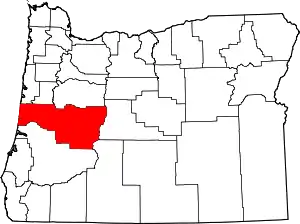 Lane County map | |
| Unincorporated communities |
| |
| Ghost towns | ||
| Indian reservation | ||
| Footnotes | ‡This populated place also has portions in an adjacent county or counties | |
| ||
