Dora Creek
Dora River is a watercourse that is located in the Upper Central Coast/Lower Hunter regions of New South Wales, Australia.
| Dora Creek Dory River[1] | |
|---|---|
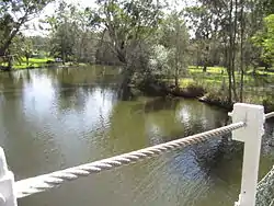 Dora Creek, view from behind Avondale College | |
| Etymology | Aboriginal: "Creek running into a lake"[2] |
| Native name | Doree Doree[2] |
| Location | |
| Country | Australia |
| State | New South Wales |
| Region | Sydney Basin (IBRA), Central Coast, Hunter |
| Local government area | Lake Macquarie |
| Physical characteristics | |
| Source | Watagan Mountains |
| • location | Martinsville |
| • elevation | 40 m (130 ft) |
| Mouth | Lake Macquarie |
• location | Dora Creek |
• elevation | 0 m (0 ft) |
| Length | 22.5 km (14.0 mi) [3] |
| Basin features | |
| Tributaries | |
| • left | Jigadee Creek |
| • right | Stockton Creek |
| National park | Watagans |
| [1][4] | |
Course and features
Dora Creek River rises below Watagan Mountains west of Martinsville, and flows generally southeast by south, joined by two minor tributaries, before reaching its river mouth within Lake Macquarie, near the town of Dora Creek. The river descends 40 metres (130 ft) over its 22.5 kilometres (14.0 mi) course.[1][4]
The merged flows of Dora Creek together with Lake Macquarie reaches the Tasman Sea of the South Pacific Ocean at Swansea.[4]
The F3 Freeway crosses the creek, west of Morisset.[4]
See also
References
- "Dora Creek". Geographical Names Register (GNR) of NSW. Geographical Names Board of New South Wales. Retrieved 6 April 2013.

- Read, Clive (2008). "Dora Creek Street Names" (PDF). City of Lake Macquarie. Retrieved 6 April 2013.
- "Extract - Geographical Names Board of NSW". www.gnb.nsw.gov.au. Retrieved 3 February 2019.
- "Map of Dora Creek, NSW". Bonzle Digital Atlas of Australia. Retrieved 6 April 2013.
External links
- "Lake Macquarie & Tuggerah Lakes catchments" (map). Office of Environment and Heritage. Government of New South Wales.
This article is issued from Wikipedia. The text is licensed under Creative Commons - Attribution - Sharealike. Additional terms may apply for the media files.