Kanangra Creek
The Kanangra Creek, a perennial stream of the Hawkesbury-Nepean catchment, is located in the Blue Mountains region of New South Wales, Australia.
| Kanangra Thurat Rivulet (Part), Konangaroo Creek, Kanangra River[1] | |
|---|---|
 | |
| Location | |
| Country | Australia |
| State | New South Wales |
| Region | Sydney Basin (IBRA), Blue Mountains |
| Municipality | Oberon Shire |
| Physical characteristics | |
| Source | Mount Thurat, Boyd Plateau |
| • location | near Mount Wallarra, Kanangra-Boyd National Park |
| • elevation | 1,110 m (3,640 ft) |
| Mouth | confluence with the Coxs River |
• location | Kanangra-Boyd National Park |
• elevation | 157 m (515 ft) |
| Length | 20 km (12 mi) |
| Basin features | |
| River system | Hawkesbury-Nepean catchment |
| Tributaries | |
| • left | Whalania Creek |
| National park | Kanangra-Boyd NP |
| [2][3] | |
Course
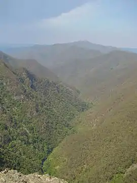
The Kanangra Creek (officially designated as a river[1]) rises near Mount Wallarra, below the Boyd Plateau on the western slopes of Mount Thurat, and flows generally south-east and north-east through Kanangra Gorge, joined by one minor tributary, before reaching its confluence with the Coxs River at Konangaroo Clearing. The river descends 950 metres (3,120 ft) over its 20-kilometre (12 mi) course. The river is entirely contained within the world heritage-listed Kanangra-Boyd National Park.[1][3]
The Kanangra Falls, a waterfall located on the river,[4] descends 225 metres (738 ft) in two drops.
Kanangra-Boyd Wilderness
The Kanangra-Boyd Wilderness is among the largest and most rugged wilderness areas in New South Wales. Situated to the south of Katoomba in the Blue Mountains and the Kanangra-Boyd National Parks, this folded belt or "Rim Rock" area is markedly different from the Permo-Triassic sandstone dominated landforms which comprise the rest of the Blue Mountains. The Kanangra Gorge, along the river floor, is cut 600–900 metres (2,000–3,000 ft) deep in rocks of the Lambie Group, and is one of Australia's deepest gorges.[5]
See also
References
- "Kanangra Creek". Geographical Names Register (GNR) of NSW. Geographical Names Board of New South Wales. Retrieved 24 December 2013.

- "Place Name Search: Kanangra Creek". Geoscience Australia. Commonwealth of Australia. 2010. Archived from the original on 25 December 2013. Retrieved 24 December 2013.
- "Map of Kanangra Creek, NSW". Bonzle Digital Atlas of Australia. Digital Atlas Pty Limited. 2013. Retrieved 24 December 2013.
- "Kanangra Falls". Geographical Names Register (GNR) of NSW. Geographical Names Board of New South Wales. Retrieved 24 December 2013.
- "Kanangra-Boyd Wilderness". NSW Wilderness Red Index. The Colong Foundation for Wilderness. 1999. Retrieved 24 December 2013.
External links
- Brennan, Tom (2013). "Kanangra to Katoomba". Bushwalking NSW. Tom Brennan.