Hawkesbury River
The Hawkesbury River (also Hawkesbury-Nepean River), is a semi–mature tide dominated drowned valley estuary[1] located to the west and north of Sydney, New South Wales, Australia. The Hawkesbury River and its associated main tributary, the Nepean River, almost encircles the metropolitan region of Sydney.
| Hawkesbury-Nepean River | |
|---|---|
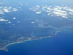 Aerial photograph showing the mouth of the Hawkesbury River as it flows into Broken Bay and out into the Tasman Sea, as seen looking across Sydney's Northern Beaches | |
| Native name | Deerubbun |
| Location | |
| Country | Australia |
| State | New South Wales |
| Region | Greater Metropolitan Sydney |
| Physical characteristics | |
| Source | Nepean River |
| • location | north of Penrith |
| 2nd source | Grose River |
| Mouth | Broken Bay |
• location | west of Lion Island |
• coordinates | 33°33′53.9994″S 151°18′0″E |
| Length | 120 km (75 mi) |
| Basin size | 21,624.1 km2 (8,349.1 sq mi) |
| Discharge | |
| • average | 95 m3/s (3,400 cu ft/s) |
| • minimum | 0 m3/s (0 cu ft/s) |
| • maximum | 15,000 m3/s (530,000 cu ft/s) |
| Basin features | |
| Tributaries | |
| • left | Colo River, Webbs Creek, Macdonald River, Mangrove Creek, Popran Creek, Mooney Mooney Creek |
| • right | Cattai Creek, South Creek, Berowra Creek |
| Islands | Milson Island, Peat Island, Spectacle Island, Long Island, and Dangar Island |
The Hawkesbury River has its origin at the confluence of the Nepean River and the Grose River, to the north of Penrith and travels for approximately 120 kilometres (75 mi) in a north–easterly and then south–easterly direction to its mouth at Broken Bay, about 15 kilometres (9.3 mi) from the Tasman Sea. The Hawkesbury River is the main tributary of Broken Bay. Secondary tributaries include Brisbane Water and Pittwater, that together with the Hawkesbury River flow into Broken Bay, and thence into the Tasman Sea north of Barrenjoey Head.
The total catchment area of the river is approximately 21,624 square kilometres (8,349 sq mi) and the area is generally administered by the Hawkesbury–Nepean Catchment Management Authority.
The land adjacent to the Hawkesbury River was occupied by Aboriginal peoples, the Darkinjung, Darug, Eora, and Kuringgai. They used the river as a source of food and a place for trade.[2]
Course
The headwaters of the Hawkesbury River, the Avon River, the Cataract River, and the Cordeaux River, rise only a few kilometres from the sea, about 80 kilometres (50 mi) south of Sydney. These streams start on the inland-facing slopes of the plateau which forms the escarpment behind Wollongong. Flowing north-west, away from the sea, these streams combine to form the Nepean River, and flow north past the towns of Camden and Penrith. Near Penrith, the Warragamba River emerges from its canyon through the Blue Mountains and joins the Nepean. The Warragamba, formed by the joining of the Wollondilly River, the Nattai River, the Kowmung River and Coxs River drains a broad region of New South Wales on the eastern side of the Great Dividing Range. The other principal component of the upper Hawkesbury river system, the Grose River, rises in the area of Mount Victoria in the Blue Mountains.
Once formed, the Hawkesbury River proper flows generally northwards, albeit with a significant number of meanders. Initially the river passes the towns of Richmond and Windsor, which are the largest settlements on the river. At Windsor, the river is joined by South Creek, which drains much of the urban runoff in Sydney's western suburbs that does not fall into the Parramatta River catchment. As it flows north, it enters a more rural area, with only small settlements on the river. On this stretch it passes Sackville and Lower Portland, where it is joined by the Colo River. The Colo River and its tributaries drain the northern section of the Blue Mountains.
From Lower Portland, the Hawkesbury River continues flowing northwards to the small community of Wisemans Ferry where it is joined by the Macdonald River. Here its course turns eastwards and the surrounding landscape gradually becomes steeper and more rugged. At Spencer, Mangrove Creek joins the river from the north. From here to the river mouth, road access to the river is limited to a few points.
At Milsons Passage, the river is joined by Berowra Creek from the south. In the area around Brooklyn the river is crossed by the major road and rail services that follow the coast north from Sydney. The river finally reaches the ocean at Broken Bay.
From the confluence of the Nepean and Grose Rivers to the sea, the Hawkesbury River has a total length of some 120 kilometres (75 mi).[3]
Islands
Islands in the Hawkesbury River include, in order going downstream are Barr Island, Milson Island, Snake Island, Peat Island, Spectacle Island, Long Island, Dangar Island and Lion Island.
Crossings
Despite forming the effective boundary of the metropolitan region of Sydney for its entire length, there are very few fixed crossings of the Hawkesbury River proper. Going downstream, these comprise:
| Crossing name (Unofficial name) |
North bank crossing location | South bank crossing location | Comments/use | Image |
|---|---|---|---|---|
| Richmond Bridge | North Richmond | Richmond | A bridge that carries the historic Bells Line of Road and formerly carried the Kurrajong extension of the Richmond railway line. | |
| Windsor Bridge | Freemans Reach | Windsor | A bridge that carries the Putty Road. | |
| Sackville Ferry | Sackville | A vehicular cable ferry. | 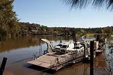 | |
| Lower Portland Ferry | Lower Portland | A vehicular cable ferry. | ||
| Webbs Creek Ferry | Wisemans Ferry | A vehicular cable ferry just upstream of the settlement of Wisemans Creek. | 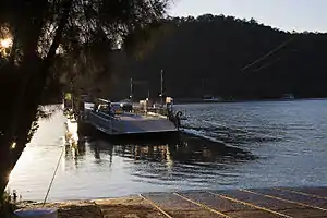 | |
| Wisemans Ferry | A vehicular cable ferry at the settlement of Wisemans Creek that carries the old Great North Road. | 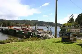 | ||
| Brooklyn Bridge | Mooney Mooney | Kangaroo Point | Carries the Sydney-Newcastle Freeway parallel to Peats Ferry Bridge. | 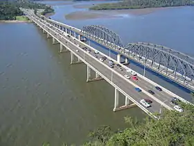 |
| Peats Ferry Bridge | An older bridge that carries the Pacific Highway. | |||
| Hawkesbury River Railway Bridge | Cogra Point | Brooklyn | A bridge that carries the Main Northern railway line. | 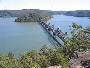 |
In the lower reaches of the river there are also a few passenger ferries that cross the river. These include the Palm Beach Ferry service from Palm Beach to Ettalong and Wagstaffe, and the Hawkesbury River Ferries service from Brooklyn to Dangar Island and Little Wobby.
History
Aboriginal Australian history
The Aboriginal name for the river was published as Deerubbun in 1870.[4] The two main Aboriginal tribes inhabiting the area were the Wannungine of the coastal area on the lower reaches (below Mangrove Creek) and the Darkinyung people, whose lands were extensive on the lower Hawkesbury to Mangrove Creek, upper Hawkesbury, inland Hunter and lower Blue Mountains.[5] Also known on the banks of the river were the Eora and Guringai people.
Australian history since colonisation
In 1789 two expeditions explored the Hawkesbury to the northwest of Sydney and the Nepean River to the southwest. It took about three years to realise they had discovered the same river system. Hawkesbury River was one of the pivotal positions of the Hawkesbury and Nepean Wars, a series of skirmishes and battles between the Kingdom of Great Britain and the resisting Indigenous clans that took place between late 1780s and late 1810s.[6]
The Hawkesbury River was one of the major transportation routes for transporting food from the surrounding area to Sydney during the 1800s. Boats would wait in the protection of Broken Bay and Pittwater, until favourable weather allowed them to make the ocean journey to Sydney Heads. With the opening of the railway from Sydney to Windsor in 1864, farm produce could be shipped upriver for onward transportation by train. However, by the 1880s the river had become silted up between Sackville and Windsor, and Sackville became the head of navigation for sea-going vessels. Until the end of the 19th century coastal steamers linked Sackville to Sydney.[7][8][9]
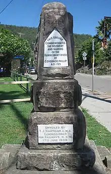
The Hawkesbury River was given its present name by Governor Phillip in June 1789, after Charles Jenkinson, 1st Earl of Liverpool, who at that time was titled Baron Hawkesbury, after the Cotswolds village of Hawkesbury Upton in England, where the Jenkinsons still live.[3] An obelisk was unveiled in 1939 at Brooklyn to commemorate the naming. In 1794, 22 families were granted land at Bardenarang, now known as Pitt Town Bottoms, near Windsor. In that same year, confrontations between Aboriginal people and settlers broke out.[10][11]
Controversy
Raising of Warragamba Dam
In May 2017, the New South Wales state government released the Hawkesbury-Nepean Valley Flood Risk Management Strategy,[12] that proposed raising the height of Warragamba Dam by an additional 17 metres, using the Climate Change Mitigation Fund. It was claimed that this would reduce the risk of flooding to homes downstream along the Hawkesbury-Nepean river, that is the most at-risk region of Australia to devastating flooding, exacerbated by Global Warming.[13] A large public opposition campaign culminating in the GIVE A DAM movement began to protect the ecological, historical and Indigenous heritage of the additional area prone to flooding due to the raising of the dam wall. A significant portion of the land to be inundated is located within the Blue Mountains World Heritage Area designated by UNESCO, which stated that this status could be revoked if parts of the world heritage area were to be submerged. Activists also claim that the raising of the dam wall will give rise to additional developments downstream, which are currently not allowed to build on floodplains with a risk of a one-in-hundred-year flood. They also claim that any raising of the dam wall will be ineffective at flood mitigation, as the Warragamba River only contributes around 15% of water volume to the Hawkesbury-Nepean system.
Windsor Bridge Replacement
Plans to replace the Windsor Bridge, and direct traffic through the historic Thompson Square caused significant community opposition culminating in the Community Action for Windsor Bridge (CAWB) movement. The State Government, despite stern public disapproval, has commenced bridge works, as of late 2018.
Third Crossing
Plans for a third crossing at Navua Reserve in Yarramundi, and at North Richmond, 50 metres from the current Richmond Bridge Site are causing public opposition. Activists do not believe that these bridges will alleviate traffic, citing that a North Richmond and Richmond by-pass is required.
River usage

Navigation
The Hawkesbury River is navigable from Windsor to the sea. There are no dams or locks on the river, and the effects of the tide are felt as far as Windsor.[14]
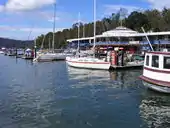
Whilst use of the river to carry farm produce and other goods has now largely been superseded by road transport, the river remains the only form of access to a significant number of isolated homes and communities. This is especially true in the lower reaches of the river, where the steep and rugged terrain inhibits road construction. One consequence of this is the operation of Australia's last riverboat postman, a river service that delivers mail to properties on the river between Brooklyn and Spencer.[15]
Sporting activities
The Hawkesbury Canoe Classic, a 111 km canoe race, is held annually in October or November. The race starts at Windsor and finishes at Brooklyn. The Bridge to Bridge Water Ski Classic is a water ski race that is run in the opposite direction, from Dangar Island to Windsor.[16][17] The Australian leg of the Red Bull Cliff Diving World Series takes place in Hawkesbury. Windsor and also Dargle ski park on the Hawkesbury river each year hold a Circuit Boat race meeting with boats travelling from all over country
Commercial fishing
According to the Hawkesbury Nepean Catchment Management Authority, the Hawkesbury River estuary supports the second-largest commercial coastal fishery of estuary prawns, oysters (prior to the outbreak of QX disease) and fish in New South Wales, with a wholesale value of $6.3 million annually.[18]
Cultural references
- Australian novelist Kate Grenville wrote an award-winning historical fiction novel The Secret River set on the Hawkesbury.
- The 2004 film Oyster Farmer is set mostly on the Hawkesbury.
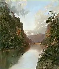
- Artists William Piguenit and Arthur Streeton painted the Hawkesbury River in the late 19th century.
- Australian Television shows, like A Country Practice and Home and Away, have used the Hawkesbury in exterior shots.
- Guide to Sydney Rivers site
See also
References
- Roy, P. S.; Williams, R. J.; Jones, A. R.; Yassini, I.; et al. (2001). "Structure and Function of South-east Australian Estuaries". Estuarine, Coastal and Shelf Science. 53: 351–384. doi:10.1006/ecss.2001.0796.
- Bear, Virginia (2010). "Aboriginal People of the Sydney Region". Australian Association of Bush Regenerators. Retrieved 27 December 2012.
- "Hawkesbury River". Geographical Names Register (GNR) of NSW. Geographical Names Board of New South Wales. Retrieved 19 December 2008.

- "The River System, Geographical Outline". The Sydney Morning Herald. p. 7. Retrieved 6 August 2011.
- "Darkiñung Recognition" (PDF). University of Sydney. 2012. Retrieved 23 September 2012.
- Connor, John (2002). The Australian frontier wars, 1788–1838. Sydney: UNSW Press. ISBN 0-86840-756-9.
- Macken, James J. Martin Burke: The Father of Pittwater. National Library of Australia.
- "Sackville Ferry". New South Wales Roads and Traffic Authority. Archived from the original on 25 August 2006. Retrieved 18 November 2008.
- Purtell, Jean (1995). The Mosquito Fleet: Hawkesbury River Trade and Traders 1794-1994.
- "Hawkesbury River". National Museum of Australia. Archived from the original on 2007-09-28.
- "Conflict at the Hawkesbury". National Museum of Australia. Archived from the original on 2007-09-28.
- "Hawkesbury-Nepean Valley Flood Risk Management Strategy". Infrastructure New South Wales.
- "Climate change in the Hawkesbury Nepean Catchment" (PDF). CSIRO.
- "Hawkesbury River - Windsor Tide Times". www.tide-times.com.au. Archived from the original on 31 July 2008. Retrieved 19 December 2008.
- "Australia's last Riverboat Postman". Hawkesbury River Tourist Services Pty Ltd. Retrieved 19 December 2008.
- "Hawkesbury Canoe Classic". Hawkesbury Canoe Classic. Retrieved 2008-12-19.
- "Bridge to Bridge Ski Race". NSW Water Ski Federation. Archived from the original on 2008-07-19. Retrieved 2008-12-19.
- "Hawkesbury River Subcatchment". Hawkesbury Nepean Catchment Management Authority. Retrieved 2007-01-05.
External links
| Wikimedia Commons has media related to Hawkesbury River. |
- Satellite photo Hawkesbury River on Google Maps
- The Hawkesbury Nepean Catchment Management Authority website
- Hawkesbury Historical Society website
- A 50's Classic Riverside Hawkesbury Boathouse
- Hawkesbury web
- Niall Clugston (2008). "Hawkesbury River". Dictionary of Sydney. Dictionary of Sydney Trust. Retrieved 6 October 2015. [CC-By-SA]
Hawkesbury River region, New South Wales, Australia | |||||||||
|---|---|---|---|---|---|---|---|---|---|
| Islands | |||||||||
| National parks and nature reserves | |||||||||
| European explorers of the region | |||||||||
| Bridges and ferries |
| ||||||||
| Adjoining rivers, bays, reservoirs, and creeks |
| ||||||||
| Local government areas | |||||||||
| Education |
| ||||||||
| Major attractions | |||||||||
| |||||||||