City of Lake Macquarie
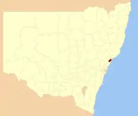
The City of Lake Macquarie is a local government area in the Hunter Region of New South Wales, Australia and was proclaimed a city from 7 September 1984. The area is situated adjacent to the city of Newcastle and is part of the Greater Newcastle Area.[12] The city is approximately 150 km (93 mi) north of Sydney. One of its major tourist attractions is its lake, also named Lake Macquarie.
| City of Lake Macquarie New South Wales | |||||||||||||||
|---|---|---|---|---|---|---|---|---|---|---|---|---|---|---|---|
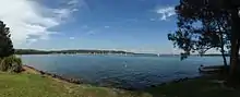
.jpg.webp) Lake Macquarie, after which the LGA is named | |||||||||||||||
 | |||||||||||||||
| Coordinates | 33°02′S 151°38′E | ||||||||||||||
| Population |
| ||||||||||||||
| • Density | 315/km2 (820/sq mi) | ||||||||||||||
| Established |
| ||||||||||||||
| Area | 648 km2 (250.2 sq mi)[3] | ||||||||||||||
| Time zone | AEST (UTC+10) | ||||||||||||||
| • Summer (DST) | AEDT (UTC+11) | ||||||||||||||
| Mayor | Kay Fraser[4] | ||||||||||||||
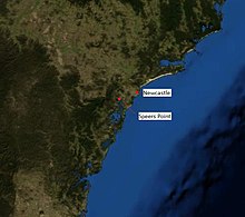
| Council seat | Speers Point | ||||||||||||||
| Region | Hunter[5] | ||||||||||||||
| State electorate(s) | |||||||||||||||
| Federal Division(s) | |||||||||||||||
| Website | City of Lake Macquarie | ||||||||||||||
| |||||||||||||||
The mayor of the City of Lake Macquarie Council is Councillor Kay Fraser, a member of the Labor Party.[4]
The Royal Australian Navy ship HMAS Tobruk was granted the Right of Freedom of Entry to the City of Lake Macquarie on 9 August 1991.[13]
History
The Shire of Lake Macquarie was proclaimed on 6 March 1906. It became a Municipality on 1 March 1977, and a city on 7 September 1984.[14][15]
Main towns and villages
Lake Macquarie is home to several prominent coastal suburbs such as Catherine Hill Bay, Caves Beach, Blacksmiths Beach and Redhead. Retail centres include Belmont, Cardiff, Charlestown, Glendale, Swansea, Toronto, and Morisset with its large area and rapidly increasing developments.
Significant population centres include:
- Belmont
- Cardiff
- Charlestown
- Cooranbong
- Glendale
- Morisset
- Mount Hutton
- Swansea
- Toronto
- Valentine
- Warners Bay
The Australian Bureau of Statistics classifies various towns and suburbs in the LGA as being part of the Newcastle Statistical District. The City of Lake Macquarie has its own independent local government (Lake Macquarie City Council). The largest commercial centre in the region is Charlestown.
Demographics
| Lake Macquarie suburbs | |||
|---|---|---|---|
| Charlestown | 11,725 | ||
| Warners Bay | 7,457 | ||
| Belmont North | 6,481 | ||
| Belmont | 6,420 | ||
| Edgeworth | 6,252 | ||
| Cardiff | 5,779 | ||
| Valentine | 5,555 | ||
The area is a set of contiguous towns that surround a coastal saltwater lake. These towns merge with the suburbs of Newcastle to the north. Some suburbs, such as Adamstown Heights are partly in the City of Newcastle and partly within the City of Lake Macquarie. There are 92 identified settlements ranging from small rural style communities through to larger and higher density areas such as Toronto, Warners Bay, Belmont, Charlestown and Morisset.
At the 2011 census, there were 189,006 people in the Lake Macquarie local government area, of these 48.8% were male and 51.2% were female. Aboriginal and Torres Strait Islander people made up 3.0% of the population, which was higher than the national and state averages. The median age of people in the City of Lake Macquarie was 41 years, which was significantly higher than the national median of 37 years. Children aged 0 – 14 years made up 18.6% of the population and people aged 65 years and over made up 18.4% of the population. Of people in the area aged 15 years and over, 51.0% were married and 12.2% were either divorced or separated.[16]
Population growth in the City of Lake Macquarie between the 2001 census and the 2006 census was 3.36%; and in the subsequent five years to the 2011 Census, population growth was 3.20%. When compared with total population growth of Australia for the same periods, being 5.78% and 8.32% respectively, population growth in Lake Macquarie local government area was approximately half the national average.[17] The median weekly income for residents within the City of Lake Macquarie was marginally below the national average.[16][18]
At the 2011 Census, the proportion of residents in the Lake Macquarie local government area who stated their ancestry as Australian or Anglo-Celtic exceeded 81% of all residents (national average was 65.2%). In excess of 58% of all residents in the City of Lake Macquarie nominated a religious affiliation with Christianity at the 2011 census, which was slightly higher than the national average of 50.2%. Meanwhile, as at the census date, compared to the national average, households in the Lake Macquarie local government area had a significantly lower than average proportion (5.4%) where two or more languages are spoken (national average was 20.4%); and a significantly higher proportion (93.0%) where English only was spoken at home (national average was 76.8%).[16]
| Census year | 2001[17] | 2006[18] | 2011[16] | 2016[1] | ||
|---|---|---|---|---|---|---|
| Population | Estimated residents on Census night | 177,185 | 183,138 | 189,006 | 197,371 | |
| LGA rank in terms of size within New South Wales | ||||||
| % of New South Wales population | 2.73% | |||||
| % of Australian population | 0.94% | |||||
| Cultural and language diversity | ||||||
| Ancestry, top responses | Australian | 33.7% | ||||
| English | 32.2% | |||||
| Scottish | 8.2% | |||||
| Irish | 7.7% | |||||
| German | 3.0% | |||||
| Language, top responses (other than English) | Italian | 0.3% | ||||
| Macedonian | 0.3% | |||||
| Mandarin | 0.3% | |||||
| Italian | 0.3% | |||||
| German | 0.3% | |||||
| Cantonese | n/c | |||||
| Spanish | n/c | n/c | ||||
| Religious affiliation | ||||||
| Religious affiliation, top responses | No Religion | 12.5% | ||||
| Anglican | 29.1% | |||||
| Catholic | 23.0% | |||||
| Uniting Church | 10.0% | |||||
| Presbyterian and Reformed | 4.4% | |||||
| Median weekly incomes | ||||||
| Personal income | Median weekly personal income | A$394 | A$520 | A$609 | ||
| % of Australian median income | 84.5% | 90.1% | ||||
| Family income | Median weekly family income | A$922 | A$1,396 | A$1,610 | ||
| % of Australian median income | 89.8% | 94.3% | ||||
| Household income | Median weekly household income | A$1,102 | A$1,177 | A$1,313 | ||
| % of Australian median income | 94.1% | 90.5% b | ||||
Economics
Lake Macquarie has a significant coal mining industry and smaller agriculture and manufacturing industries. Eraring power station, a 1980s-era coal-fired power station, supplies 25% of New South Wales' power.[19] Lake Macquarie has a number of Constructed Wetlands with the council placing an emphasis on the environment.
Council
Current composition and election method
Lake Macquarie City Council is composed of thirteen Councillors, including the mayor, for a fixed four-year term of office. The mayor is directly elected while the twelve other Councillors are elected proportionally as three separate wards, each electing four Councillors. The most recent election was held on the 10th of September 2016, and the makeup of the Council, including the mayor, is as follows:[4]
| Party | Councillors | |
|---|---|---|
| Labor Party | 6 | |
| Liberal Party | 3 | |
| Independent Lake Alliance | 1 | |
| Lake Mac Independents | 3 | |
| Total | 13 | |
The current Council, elected in 2016, in order of election by ward, is:
| Ward | Councillor | Party | Notes | |
|---|---|---|---|---|
| Mayor[4] | Kay Fraser | Labor | ||
| East Ward[20] | Adam Shultz | Labor | ||
| Nick Jones | Liberal | |||
| Christine Buckley | Labor | |||
| John Gilbert | Lake Mac Independents | |||
| North Ward[21] | Brian Adamthwaite | Labor | ||
| Kevin Baker | Liberal | |||
| Barney Langford | Labor | |||
| Colin Grigg | Lake Mac Independents | |||
| West Ward[22] | David Belcher | Labor | ||
| Jason Pauling | Liberal | |||
| Wendy Harrison | Independent Lake Alliance | |||
| Luke Cubis | Lake Mac Independents | |||
Shopping
Major shopping centres include:
- Charlestown Square
- Stockland Glendale
- Lake Macquarie Square
Arts and culture
Lake Macquarie has a number of cultural and artistic locations:[23]
- Dobell House - last residence of William Dobell, Wangi Wangi
- Finite Gallery, Caves Beach Fine Arts and Crafts
- Lake Macquarie City Art Gallery, Booragul
- Richmond Vale Railway Museum, Richmond Vale
- South Sea Islands Museum and Sunnyside Historic Home, Cooranbong
- The Friends of Rathmines Incorporated, Rathmines Park
Sister cities
The City of Lake Macquarie has sister city relations with the following cities:[24]
- Hakodate, Hokkaidō, Japan
- Tanagura, Fukushima, Japan
- Rotorua, Bay of Plenty, New Zealand
- Round Rock, Texas, United States of America [25]
References
- Australian Bureau of Statistics (27 June 2017). "Lake Macquarie (C)". 2016 Census QuickStats. Retrieved 6 November 2018.

- "3218.0 – Regional Population Growth, Australia, 2017-18". Australian Bureau of Statistics. 27 March 2019. Retrieved 27 March 2019. Estimated resident population (ERP) at 30 June 2018.
- Australian Bureau of Statistics (31 October 2012). "2011 Community Profiles: Lake Macquarie (Local Government Area)". 2011 Census of Population and Housing. Retrieved 10 September 2012.
- "Lake Macquarie City Council Results (2016)". Lake Macquarie City Council. 19 September 2016. Archived from the original on 26 March 2017. Retrieved 25 March 2017.
- "Suburb Search – Local Council Boundaries – Hunter (HT) – Lake Macquarie City Council". New South Wales Division of Local Government. Archived from the original on 16 January 2013. Retrieved 6 October 2012.
- "Lake Macquarie Electoral District". New South Wales Electoral Commission. Retrieved 23 November 2019.
- "Swansea Electoral District". New South Wales Electoral Commission. Retrieved 23 November 2019.
- "Charlestown Electoral District". New South Wales Electoral Commission. Retrieved 23 November 2019.
- "Cessnock Electoral District". New South Wales Electoral Commission. Retrieved 23 November 2019.
- "Wallsend Electoral District". New South Wales Electoral Commission. Retrieved 23 November 2019.
- "Shortland". Australian Electoral Commission. 26 July 2012. Archived from the original on 24 December 2013. Retrieved 6 October 2012.
- "Greater Newcastle metropolitan planning - Department of Planning and Environment". www.planning.nsw.gov.au. Retrieved 13 July 2017.
- Piper, Greg (April 2010). "Legend of ANZAC". p. 6. Archived from the original (PDF) on 8 October 2011. Retrieved 15 June 2011.
- "Council History: Lake Macquarie City Council". City of Lake Macquarie. 2 March 2007. Retrieved 1 June 2008.
- "Hunter History Highlights". Hunter Valley Research Foundation. Archived from the original on 25 December 2007. Retrieved 1 June 2008.
- Australian Bureau of Statistics (31 October 2012). "Lake Macquarie (C) (Local Government Area)". 2011 Census QuickStats. Retrieved 10 September 2012.
- Australian Bureau of Statistics (9 March 2006). "Lake Macquarie (C)". 2001 Census QuickStats. Retrieved 17 December 2012.
- Australian Bureau of Statistics (25 October 2007). "Lake Macquarie (C)". 2006 Census QuickStats. Retrieved 17 December 2012.
- "Eraring Power Station". Hunter New England Area Health Service. 2005. Archived from the original on 13 November 2007. Retrieved 1 June 2008.
- "Elections NSW - Lake Macquarie City Council Elections 2016 - East Ward" (PDF).
- "Elections NSW - Lake Macquarie City Council Elections 2016 - North Ward" (PDF).
- "Elections NSW - Lake Macquarie City Council Elections 2016 - West Ward" (PDF).
- "Arts and Culture - Lake Macquarie NSW Accommodation & Holiday Rentals - tourist visitor information & guide, accommodation bookings, attractions, activities, NSW maps & much more". Retrieved 31 March 2016.
- "Sister Cities". Lake Macquarie City Council. Retrieved 18 December 2012.
- "Round Rock, Texas Political Structure". Round Rock City Council. Retrieved 12 February 2020.
External links
| Wikivoyage has a travel guide for City of Lake Macquarie, New South Wales. |
| Wikimedia Commons has media related to City of Lake Macquarie. |
- Lake Macquarie City Council
- Lake Macquarie Business Directory
- Lake Macquarie City
- Clickable map of New South Wales LGAs (NSW Dept. of Local Government)
- Rathmines Community Website and Forum
- "Shires of Australia". Statoids.