Dorchester, New Hampshire
Dorchester is a town in Grafton County, New Hampshire, United States. The population was 355 at the 2010 census.[1]
Dorchester, New Hampshire | |
|---|---|
Town | |
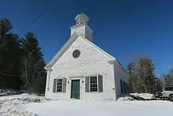 Dorchester Community Church | |
 Seal | |
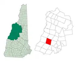 Location in Grafton County, New Hampshire | |
| Coordinates: 43°45′24″N 71°56′55″W | |
| Country | United States |
| State | New Hampshire |
| County | Grafton |
| Incorporated | 1772 |
| Villages | Dorchester Bucks Corner Cheever North Dorchester |
| Government | |
| • Board of Selectmen | Sherman Hallock, Chair Craig Veasey Amber Barsaleau |
| Area | |
| • Total | 45.2 sq mi (117.2 km2) |
| • Land | 44.7 sq mi (115.7 km2) |
| • Water | 0.6 sq mi (1.4 km2) 1.22% |
| Elevation | 1,391 ft (424 m) |
| Population (2010) | |
| • Total | 355 |
| • Density | 7.9/sq mi (3.0/km2) |
| Time zone | UTC-5 (Eastern) |
| • Summer (DST) | UTC-4 (Eastern) |
| ZIP code | 03266 |
| Area code(s) | 603 |
| FIPS code | 33-18740 |
| GNIS feature ID | 0873579 |
| Website | townofdorchester |
History
Originally granted by Governor Benning Wentworth in 1761, Dorchester was named for Dorchester in Dorset, England. When the recipients failed to take up the grant, it was regranted in 1766, but also without success. Finally, it was regranted by Governor John Wentworth to 72 people on May 1, 1772, and settlement began soon thereafter. The first settlers were Benjamin Rice and Stephen Murch from Hanover, but originally from Connecticut.[2]
When the first census of Dorchester was taken in 1790, there were 175 residents. By 1859, when the population reached 711, there were eleven sawmills, in addition to several clapboard and shingle mills. Charcoal was also manufactured here.[3]
Geography
According to the United States Census Bureau, the town has a total area of 45.2 square miles (117 km2), of which 44.7 sq mi (116 km2) is land and 0.6 sq mi (1.6 km2) is water, comprising 1.22% of the town. It is drained by the South Branch Baker River and Indian River. The highest point in Dorchester is on its western boundary, where the elevation reaches 3,190 feet (970 m) above sea level, just east of the summit of Smarts Mountain. Dorchester lies within two watersheds — roughly the southwestern half of town is in the Connecticut River watershed and the northeastern half is in the Merrimack River watershed.[4]
The town is crossed by New Hampshire Route 118.
Demographics
| Historical population | |||
|---|---|---|---|
| Census | Pop. | %± | |
| 1790 | 175 | — | |
| 1800 | 349 | 99.4% | |
| 1810 | 537 | 53.9% | |
| 1820 | 584 | 8.8% | |
| 1830 | 702 | 20.2% | |
| 1840 | 769 | 9.5% | |
| 1850 | 711 | −7.5% | |
| 1860 | 691 | −2.8% | |
| 1870 | 689 | −0.3% | |
| 1880 | 585 | −15.1% | |
| 1890 | 370 | −36.8% | |
| 1900 | 308 | −16.8% | |
| 1910 | 241 | −21.8% | |
| 1920 | 228 | −5.4% | |
| 1930 | 115 | −49.6% | |
| 1940 | 144 | 25.2% | |
| 1950 | 133 | −7.6% | |
| 1960 | 91 | −31.6% | |
| 1970 | 141 | 54.9% | |
| 1980 | 244 | 73.0% | |
| 1990 | 392 | 60.7% | |
| 2000 | 353 | −9.9% | |
| 2010 | 355 | 0.6% | |
| 2017 (est.) | 355 | [5] | 0.0% |
| U.S. Decennial Census[6] | |||
At the 2000 census there were 353 people, 132 households, and 99 families in the town. The population density was 7.9 people per square mile (3.0/km2). There were 236 housing units at an average density of 5.3 per square mile (2.0/km2). The racial makeup of the town was 97.17% White, 0.28% African American, 0.28% Native American, 0.85% Asian, 0.85% from other races, and 0.57% from two or more races. Hispanic or Latino of any race were 0.57%.[7]
Of the 132 households 35.6% had children under the age of 18 living with them, 59.8% were married couples living together, 9.8% had a female householder with no husband present, and 25.0% were non-families. 19.7% of households were one person and 6.1% were one person aged 65 or older. The average household size was 2.67 and the average family size was 3.02.
The age distribution was 27.5% under the age of 18, 5.4% from 18 to 24, 26.3% from 25 to 44, 28.9% from 45 to 64, and 11.9% 65 or older. The median age was 40 years. For every 100 females, there were 98.3 males. For every 100 females age 18 and over, there were 95.4 males.
The median household income was $40,833 and the median family income was $42,292. Males had a median income of $35,000 versus $24,375 for females. The per capita income for the town was $18,940. About 8.6% of families and 11.3% of the population were below the poverty line, including 17.2% of those under age 18 and 9.5% of those age 65 or over.
Notable people
- Rufus Blodgett, US senator from New Jersey
- Albert Woodworth, businessman and state legislator
References
- United States Census Bureau, American FactFinder, 2010 Census figures. Retrieved March 23, 2011.
- History of Dorchester, Grafton County, New Hampshire
- Coolidge, Austin J.; John B. Mansfield (1859). A History and Description of New England. Boston, Massachusetts. p. 467.
- Foster, Debra H.; Batorfalvy, Tatianna N.; Medalie, Laura (1995). Water Use in New Hampshire: An Activities Guide for Teachers. U.S. Department of the Interior and U.S. Geological Survey.
- "Annual Estimates of the Resident Population: April 1, 2010 to July 1, 2017 (PEPANNRES): Minor Civil Divisions – New Hampshire". Archived from the original on February 13, 2020. Retrieved November 14, 2018.
- "Census of Population and Housing". Census.gov. Retrieved June 4, 2016.
- "U.S. Census website". United States Census Bureau. Retrieved 2008-01-31.
External links
- Town of Dorchester official website
- New Hampshire Economic and Labor Market Information Bureau Profile
Places adjacent to Dorchester, New Hampshire | |
|---|---|
Municipalities and communities of Grafton County, New Hampshire, United States | ||
|---|---|---|
| City | 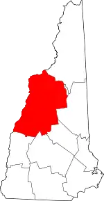 Map of New Hampshire highlighting Grafton County | |
| Towns |
| |
| Township | ||
| CDPs | ||
| Other villages | ||
| ||