Thornton, New Hampshire
Thornton is a town in Grafton County, New Hampshire, United States. The population was 2,490 at the 2010 census.[2]
Thornton, New Hampshire | |
|---|---|
Town | |
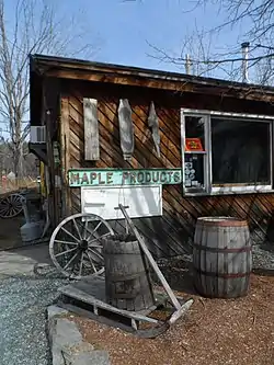 Sugar shack in Thornton | |
 Seal | |
 Location in Grafton County, New Hampshire | |
| Coordinates: 43°53′34″N 71°40′33″W | |
| Country | United States |
| State | New Hampshire |
| County | Grafton |
| Incorporated | 1763 |
| Villages | Thornton West Thornton |
| Government | |
| • Board of Selectmen | Marianne Peabody, Chair Brad Benton John "Jack" Gaites Joseph Monti Roy Sabourn[1] |
| • Town Administrator | Debra Shepard |
| Area | |
| • Total | 50.8 sq mi (131.5 km2) |
| • Land | 50.2 sq mi (130.0 km2) |
| • Water | 0.6 sq mi (1.6 km2) 1.19% |
| Elevation | 617 ft (188 m) |
| Population (2010) | |
| • Total | 2,490 |
| • Density | 49/sq mi (19/km2) |
| Time zone | UTC-5 (Eastern) |
| • Summer (DST) | UTC-4 (Eastern) |
| ZIP code | 03285 |
| Area code(s) | 603 |
| FIPS code | 33-76740 |
| GNIS feature ID | 0873738 |
| Website | www |
History
Thornton was incorporated in 1763, and named for Doctor Matthew Thornton, a signer of the Declaration of Independence.[3]
Geography
According to the United States Census Bureau, the town has a total area of 50.8 square miles (131.6 km2), of which 50.2 square miles (130.0 km2) is land and 0.6 square miles (1.6 km2) is water, comprising 1.19% of the town.[4] The highest point in Thornton is 2,580 feet (790 m) above sea level on the western ridge of Dickey Mountain, whose 2,734-foot (833 m) summit lies in the neighboring town of Waterville Valley.
Demographics
| Historical population | |||
|---|---|---|---|
| Census | Pop. | %± | |
| 1790 | 385 | — | |
| 1800 | 535 | 39.0% | |
| 1810 | 794 | 48.4% | |
| 1820 | 857 | 7.9% | |
| 1830 | 1,049 | 22.4% | |
| 1840 | 1,045 | −0.4% | |
| 1850 | 1,011 | −3.3% | |
| 1860 | 967 | −4.4% | |
| 1870 | 840 | −13.1% | |
| 1880 | 775 | −7.7% | |
| 1890 | 632 | −18.5% | |
| 1900 | 552 | −12.7% | |
| 1910 | 553 | 0.2% | |
| 1920 | 477 | −13.7% | |
| 1930 | 459 | −3.8% | |
| 1940 | 501 | 9.2% | |
| 1950 | 460 | −8.2% | |
| 1960 | 480 | 4.3% | |
| 1970 | 594 | 23.8% | |
| 1980 | 952 | 60.3% | |
| 1990 | 1,505 | 58.1% | |
| 2000 | 1,843 | 22.5% | |
| 2010 | 2,490 | 35.1% | |
| 2017 (est.) | 2,492 | [5] | 0.1% |
| U.S. Decennial Census[6] | |||
At the 2000 census there were 1,843 people, 759 households, and 507 families living in the town. The population density was 36.6 people per square mile (14.1/km2). There were 1,487 housing units at an average density of 29.5 per square mile (11.4/km2). The racial makeup of the town was 97.61% White, 0.27% African American, 0.11% Native American, 0.27% Asian, 0.05% Pacific Islander, 0.33% from other races, and 1.36% from two or more races. Hispanic or Latino of any race were 0.71%.[7]
Of the 759 households 29.6% had children under the age of 18 living with them, 56.5% were married couples living together, 6.6% had a female householder with no husband present, and 33.2% were non-families. 21.1% of households were one person and 6.6% were one person aged 65 or older. The average household size was 2.43 and the average family size was 2.86.
The age distribution was 22.4% under the age of 18, 7.5% from 18 to 24, 33.1% from 25 to 44, 24.6% from 45 to 64, and 12.4% 65 or older. The median age was 38 years. For every 100 females, there were 99.2 males. For every 100 females age 18 and over, there were 102.5 males.
The median household income was $38,380 and the median family income was $45,172. Males had a median income of $27,750 versus $22,938 for females. The per capita income for the town was $18,478. About 6.9% of families and 9.5% of the population were below the poverty line, including 13.5% of those under age 18 and 3.0% of those age 65 or over.
Notable people
- Moses Cheney (1793–1875), 19th century abolitionist
- Karl Drerup (1904–2000), German-American enamels artist
- Nevin S. Scrimshaw (1918–2013), nutritionist, winner of World Food Prize
References
- "Board of Selectmen". Town of Thornton. Retrieved July 28, 2020.
- United States Census Bureau, American FactFinder, 2010 Census figures. Retrieved March 23, 2011.
- "NH History and Heritage Guide". www.aannh.org. Retrieved 2018-02-01.
- "Geographic Identifiers: 2010 Demographic Profile Data (G001) - Thornton town, New Hampshire". United States Census Bureau. Retrieved November 13, 2011.
- "Annual Estimates of the Resident Population: April 1, 2010 to July 1, 2017 (PEPANNRES): Minor Civil Divisions – New Hampshire". Archived from the original on February 13, 2020. Retrieved November 14, 2018.
- "Census of Population and Housing". Census.gov. Retrieved June 4, 2016.
- "U.S. Census website". United States Census Bureau. Retrieved 2008-01-31.
External links
- Town of Thornton official website
- New Hampshire Economic and Labor Market Information Bureau Profile
Places adjacent to Thornton, New Hampshire | |
|---|---|
Municipalities and communities of Grafton County, New Hampshire, United States | ||
|---|---|---|
| City | 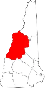 Map of New Hampshire highlighting Grafton County | |
| Towns |
| |
| Township | ||
| CDPs | ||
| Other villages | ||
| ||
| Authority control |
|---|