Enfield (CDP), New Hampshire
Enfield is a census-designated place (CDP) and the main village in the town of Enfield in Grafton County, New Hampshire, United States. The population of the CDP was 1,540 at the 2010 census,[1] out of 4,582 people in the entire town of Enfield.
Enfield, New Hampshire | |
|---|---|
 Enfield  Enfield | |
| Coordinates: 43°38′26″N 72°8′38″W | |
| Country | United States |
| State | New Hampshire |
| County | Grafton |
| Town | Enfield |
| Area | |
| • Total | 2.33 sq mi (6.03 km2) |
| • Land | 2.27 sq mi (5.87 km2) |
| • Water | 0.06 sq mi (0.15 km2) |
| Elevation | 807 ft (246 m) |
| Population (2010) | |
| • Total | 1,540 |
| • Density | 679/sq mi (262.1/km2) |
| Time zone | UTC-5 (Eastern (EST)) |
| • Summer (DST) | UTC-4 (EDT) |
| ZIP code | 03748 |
| Area code(s) | 603 |
| FIPS code | 33-24260 |
| GNIS feature ID | 2378061 |
Geography
The CDP is in the northwest corner of the town of Enfield, on the north side of Mascoma Lake where the Mascoma River enters it. The CDP is bordered to the south by Mascoma Lake, as far as Rainier Road on the east side of the lake; to the west by the city of Lebanon; to the north by the town of Canaan; and to the east by Shaker Boulevard, Wescott Road, and the Northern Rail Trail running east to the Canaan line.[2]
U.S. Route 4 passes through the community, leading east 7 miles (11 km) to Canaan village and west the same distance to the center of Lebanon.
According to the U.S. Census Bureau, the Enfield CDP has a total area of 2.33 square miles (6.03 km2), of which 2.27 square miles (5.87 km2) are land and 0.06 square miles (0.15 km2), or 2.56%, are water.[1]
Demographics
As of the census of 2010, there were 1,540 people, 712 households, and 419 families residing in the CDP. There were 787 housing units, of which 75, or 9.5%, were vacant. The racial makeup of the town was 96.4% white, 0.6% African American, 0.1% Native American or Alaska Native, 0.5% Asian, 0.4% some other race, and 1.9% from two or more races. 1.4% of the population were Hispanic or Latino of any race.[3]
Of the 712 households, 28.1% had children under the age of 18 living with them, 40.7% were headed by married couples living together, 13.1% had a female householder with no husband present, and 41.2% were non-families. 34.1% of all households were made up of individuals, and 10.0% were someone living alone who was 65 years of age or older. The average household size was 2.16, and the average family size was 2.75.[3]
21.4% of the population were under the age of 18, 8.2% were from age 18 to 24, 27.6% were 25 to 44, 27.5% were 45 to 64, and 15.3% were 65 years of age or older. The median age was 39.7 years. For every 100 females, there were 89.0 males. For every 100 females age 18 and over, there were 86.7 males.[3]
For the period 2011-2015, the estimated median annual income for a household in the CDP was $75,313, and the median income for a family was $91,369. Male full-time workers had a median income of $47,950 versus $42,841 for females. The per capita income for the CDP was $49,008.[4]
References
- "Geographic Identifiers: 2010 Demographic Profile Data (G001): Enfield CDP, New Hampshire". U.S. Census Bureau, American Factfinder. Archived from the original on February 13, 2020. Retrieved August 31, 2017.
- "TIGERweb: Enfield CDP, New Hampshire". Geography Division, U.S. Census Bureau. Retrieved January 25, 2021.
- "Profile of General Population and Housing Characteristics: 2010 Census Summary File 1 (DP-1): Enfield CDP, New Hampshire". U.S. Census Bureau, American Factfinder. Archived from the original on April 15, 2015. Retrieved April 15, 2015.
- "Selected Economic Characteristics: 2011-2015 American Community Survey 5-Year Estimates (DP03): Enfield CDP, New Hampshire". U.S. Census Bureau, American Factfinder. Archived from the original on February 13, 2020. Retrieved August 31, 2017.
Municipalities and communities of Grafton County, New Hampshire, United States | ||
|---|---|---|
| City | 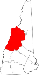 Map of New Hampshire highlighting Grafton County | |
| Towns |
| |
| Township | ||
| CDPs | ||
| Other villages | ||
| ||