Enfield Center, New Hampshire
Enfield Center is an unincorporated community in the town of Enfield in Grafton County, New Hampshire. It is a separate community from the much larger village of Enfield, which is located in the northern corner of the town.
Enfield Center, New Hampshire | |
|---|---|
 | |
 Enfield Center  Enfield Center | |
| Coordinates: 43°35′25″N 72°06′36″W | |
| Country | United States |
| State | New Hampshire |
| County | Grafton |
| Town | Enfield |
| Elevation | 869 ft (265 m) |
| Time zone | UTC-5 (Eastern (EST)) |
| • Summer (DST) | UTC-4 (EDT) |
| ZIP code | 03749 |
| Area code(s) | 603 |
| GNIS feature ID | 866803[1] |
Enfield Center is located, as the name suggests, near the geographic center of the town of Enfield. It lies along New Hampshire Route 4A, about 1 mile (1.6 km) south of the south end of Mascoma Lake and about 3 miles (5 km) south of Enfield village. The Knox River flows north through the village on its way from George Pond to Mascoma Lake.
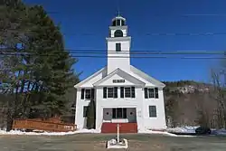
Enfield Center has a separate ZIP code (03749) from the rest of the town of Enfield. Two of its buildings are listed on the National Register of Historic Places; the Centre Village Meeting House (also known as the Union Church) and the Enfield Center Town House.
References
Municipalities and communities of Grafton County, New Hampshire, United States | ||
|---|---|---|
| City | 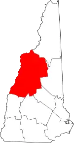 Map of New Hampshire highlighting Grafton County | |
| Towns |
| |
| Township | ||
| CDPs | ||
| Other villages | ||
| ||