Dumfries Parish, New Brunswick
Dumfries is a civil parish in York County, New Brunswick, Canada.[2]
Dumfries | |
|---|---|
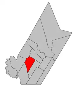 Location within York County, New Brunswick. | |
| Coordinates: 45.965°N 67.15°W | |
| Country | |
| Province | |
| County | York |
| Erected | 1833 |
| Area | |
| • Land | 302.72 km2 (116.88 sq mi) |
| Population (2016)[1] | |
| • Total | 356 |
| • Density | 1.2/km2 (3/sq mi) |
| • Change 2011-2016 | |
| • Dwellings | 334 |
| Time zone | UTC-4 (AST) |
| • Summer (DST) | UTC-3 (ADT) |
For governance purposes it forms the local service district of the parish of Dumfries,[3] which is a member of Regional Service Commission 11 (RSC11).[4]
Origin of name
The parish may have been named in honour of Capt. Adam Allen, a Loyalist born in Dumfries, Scotland, who settled at the mouth of the Pokiok River.[5]
History
Dumfries was erected in 1833 from Prince William Parish. and that part of Woodstock Parish south of the Carleton County line.[6]
In 1834 the county line was altered to follow grant lines when it neared the Saint John River, transferring several small areas between Dumfries and Woodstock.[7]
In 1836 the Saint John River islands in front of Dumfries were formally added to the parish,[8] correcting an oversight in the legislation erecting Dumfries.
In 1850 Big and Little Coac Islands were removed from Dumfries.[9]
In 1855 the western part of Dumfries was erected as Canterbury Parish.[10]
In 1895 the rear of Dumfries was included in the newly erected McAdam Parish.[11]
In 1973 the islands in the Saint John River were removed from the parish.[12] The islands were flooded by the Mactaquac Dam.
Delineation
Dumfries Parish is defined in the Territorial Division Act[2] as being bounded:
- Southeast by Prince William Parish; northeast by the Saint John River; west and northwest by the upper sideline of lot numbered six, granted to John Benn, and a line running southwesterly from the southwest angle thereof, parallel to the upper line of Prince William Parish; and southwest by eastern lines of the grants to the New Brunswick and Canada Railway and Land Company, east of the Canadian Pacific Railroad, being commonly called "The Belt Line," and the said Belt Line being continued northerly as surveyed by Deputy Alfred Whitehead, in the year one thousand eight hundred and fifty-nine.
Governance
The entire parish forms the local service district of the parish of Dumfries, established in 1966 to assess for fire protection. Community services were added to the assessment in 1967 and first aid and ambulance services in 1978.
Communities
Parish population total does not include incorporated municipalities (in bold):
Bodies of water
Bodies of water at least partly in the parish
- Saint John River
Demographics
PopulationPopulation trend[13][14][15][1]
|
LanguageMother tongue (2016)[1]
|
See also
References
- "Census Profile, 2016 Census Dumfries, Parish [Census subdivision], New Brunswick". Statistics Canada. Retrieved October 7, 2019.
- "Chapter T-3 Territorial Division Act". Government of New Brunswick. Retrieved 13 November 2020.
- "New Brunswick Regulation 84-168 under the Municipalities Act (O.C. 84-582)". Government of New Brunswick. Retrieved 25 July 2020.
- "Communities in each of the 12 Regional Service Commissions (RSC) / Les communautés dans chacune des 12 Commissions de services régionaux (CSR)" (PDF), Government of New Brunswick, July 2017, retrieved 2 February 2021
- Ganong, William F. (1896). A Monograph of the Place-Nomenclature of the Province of New Brunswick. Royal Society of Canada. p. 231.
- "3 Wm. IV c. 38 An Act to alter the Names of certain Parts of Three Parishes in the County of York, and to erect Two separate Parishes therein.". Acts of the General Assembly of His Majesty's Province of New Brunswick, Passed in the Year 1833. Fredericton: Government of New Brunswick. 1833. pp. 181–182.
- "4 Wm. IV c. 28 An Act to alter the Division Line between the Counties of York and Carleton.". Acts of the General Assembly of His Majesty's Province of New Brunswick, Passed in the Year 1834. Fredericton: Government of New Brunswick. 1834. pp. 71–72.
- "6 Wm. IV c. 45 An Act to amend and explain an Act, intituled An Act to alter the names of certain parts of three Parishes in the County of York, and to erect two separate Parishes therein.". Acts of the General Assembly of His Majesty's Province of New Brunswick, Passed in the Year 1836. Fredericton: Government of New Brunswick. 1836. p. 118.
- "13 Vic. c. 51 An Act to consolidate all the Laws now in force for the division of the Province into Counties, Towns and Parishes.". Acts of the General Assembly of Her Mjaesty's Province of New Brunswick, Passed in the Year 1850. Fredericton: Government of New Brunswick. 1850. pp. 142–152, 145–149. Book was poorly proofread, resulting in title typo and reuse of page numbers 145–152.
- "18 Vic. c. 45 An Act to erect a part of the Parish of Dumfries, in the County of York, into a separate Town or Parish.". Acts of the General Assembly of Her Majesty's Province of New Brunswick, Passed in the Month of November, 1854, and in the Months of February, March, and April, 1855. Fredericton: Government of New Brunswick. 1855. pp. 174–175.
- "57 Vic. c. 34 An Act to erect part of the Parishes of Prince William and Dumfries, in the County of York, into a separate Parish.". Acts of the General Assembly of Her Majesty's Province of New Brunswick. Passed in the Month of April, 1894. Fredericton: Government of New Brunswick. 1894. pp. 157–160.
- "Chapter T-3 Territorial Division Act". Revised Statutes of New Brunswick 1973 Volume IV. Fredericton: Government of New Brunswick. 1973. pp. 1–70. The original printed version is cited separately to distinguish it from the edited version available online.
- Statistics Canada: 1996, 2001, 2006 census
- 2006 Statistics Canada Community Profile: Dumfries Parish, New Brunswick
- 2011 Statistics Canada Census Profile: Dumfries Parish, New Brunswick
Places adjacent to Dumfries Parish, New Brunswick | |
|---|---|
| Subdivisions | |
|---|---|
| Cities | |
| Counties | |
| |