Queensbury Parish, New Brunswick
Queensbury is a civil parish in York County, New Brunswick, Canada.[2]
Queensbury | |
|---|---|
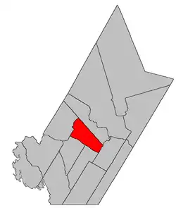 Location within York County. | |
| Coordinates: 45.9625°N 67.015°W | |
| Country | |
| Province | |
| County | York |
| Erected | 1786 |
| Area | |
| • Land | 300.65 km2 (116.08 sq mi) |
| Population (2016)[1] | |
| • Total | 1,174 |
| • Density | 3.9/km2 (10/sq mi) |
| • Change 2011-2016 | |
| • Dwellings | 587 |
| Time zone | UTC-4 (AST) |
| • Summer (DST) | UTC-3 (ADT) |
For governance purposes it forms the local service district of the parish of Queensbury,[3] which is a member of Regional Service Commission 11 (RSC11).[4]
Origin of name
The area was settled by the Queen's Rangers,[5] a Loyalist unit named in honour of Queen Charlotte.
History
Queensbury was erected in 1786 as one of the original parishes of York County.[6]
In 1824 part of Queensbury was included in the newly erected Douglas Parish.[7]
In 1835 the boundary between Queensbury and Douglas was moved upriver, removing territory from Queensbury.[8]
In 1842 the interior boundary with Douglas was altered.[9]
In 1847 four islands in the Saint John River were transferred from Prince William Parish.[10] Big Coac, Little Coac, and Great Bear all appear on the cadastral map of the area;[11] Bloodworth appears as Heustis Island, which was granted to N. Bloodworth.
In 1865 the boundary with Southampton Parish was altered,[12] adding the remainder of the Caverhill Settlement to Queensbury.
In 1973 all mention of islands in the Saint John River was removed.[13] The islands were flooded by the Mactaquac Dam.
Delineation
Queensbury Parish is defined in the Territorial Division Act[2] as being bounded:
- Northeast by Bright Parish; south and southwest by the Saint John River; and northwest by a line commencing at the Saint John River, at the southern angle of lot number one, granted to Joseph Cunliff, near the mouth of the Nackawic Stream; thence running northeasterly along the lower or southeastern line of said lot and its prolongation until it strikes the southwestern line of land granted to William Dobie, in Caverhill; thence northwesterly along the said line of said grant and its prolongation till it strikes the southeastern line of a grant to Henry Morehouse and three others; thence northeasterly along the line of said grant to its eastern angle; thence northwesterly along the northeast side of the said grant till it strikes the East Branch Nackawic Stream; thence following the course of the said river up stream to the forks at the mouth of the Burtt Lake Branch and thence following the course of the said Burtt Lake Branch up stream till it strikes the line of the parish of Bright.
Governance
The entire parish forms the local service district of the parish of Queensbury, established in 1966 to assess for fire protection. Community services were added in 1967 and first aid and ambulance services in 1978.
Communities
Parish population total does not include incorporated municipalities (in bold):
|
|
|
Bodies of water
Bodies of water at least partly in the parish
- Saint John River
Demographics
PopulationPopulation trend[14][15][16][1]
|
LanguageMother tongue (2016)[1]
|
See also
References
- "Census Profile, 2016 Census Queensbury, Parish [Census subdivision], New Brunswick". Statistics Canada. Retrieved October 7, 2019.
- "Chapter T-3 Territorial Division Act". Government of New Brunswick. Retrieved 13 November 2020.
- "New Brunswick Regulation 84-168 under the Municipalities Act (O.C. 84-582)". Government of New Brunswick. Retrieved 25 July 2020.
- "Communities in each of the 12 Regional Service Commissions (RSC) / Les communautés dans chacune des 12 Commissions de services régionaux (CSR)" (PDF), Government of New Brunswick, July 2017, retrieved 2 February 2021
- Ganong, William F. (1896). A Monograph of the Place-Nomenclature of the Province of New Brunswick. Royal Society of Canada. p. 264.
- "26 Geo. III Chapter I. An Act for the better ascertaining and confirming the Boundaries of the several Counties within this Province, and for subdividing them into Towns or Parishes.". Acts of the General Assembly of His Majesty's Province of New-Brunswick, passed in the year 1786. Saint John, New Brunswick: Government of New Brunswick. 1786. pp. 3–12.
- "5 Geo. IV c. 27 An Act for erecting a part of the Parishes of Saint Mary and Queensbury, in the County of York, into a separate and distinct Town or Parish.". Acts of the General Assembly of His Majesty's Province of New-Brunswick, Passed in the Year 1824. Fredericton: Government of New Brunswick. 1824. pp. 63–65.
- "5 Wm. IV c. 32 An Act to alter the division line between the Parishes of Douglas and Queensbury in the County of York.". Acts of the General Assembly of His Majesty's Province of New-Brunswick, Passed in the Year 1835. Fredericton: Government of New Brunswick. 1835. pp. 40–41.
- "5 Vic. c. 11 An Act to alter the Division Line of the Parishes of Douglas and Queensbury, in the County of York.". Acts of the General Assembly of Her Majesty's Province of New Brunswick, Passed in the Year 1842. Fredericton: Government of New Brunswick. 1842. p. 10.
- "9 Vic. c. 39 An Act to annex certain Islands in the River Saint John to the Parish of Queensbury, in the County of York.". Acts of the General Assembly of Her Majesty's Province of New Brunswick, Passed in the Year 1846. Fredericton: Government of New Brunswick. 1846. p. 42.
- "No. 125". Provincial Archives of New Brunswick. Department of Natural Resources and Energy Development. Retrieved 24 October 2020.
- "28 Vic. c. 52 An Act to alter and the division line between the Parishes of Queensbury and Southampton in the County of York.". Acts of the General Assembly of Her Majesty's Province of New Brunswick, Passed in the Months of May & June 1865. Fredericton: Government of New Brunswick. 1865. pp. 150–151.
- "Chapter T-3 Territorial Division Act". Revised Statutes of New Brunswick 1973 Volume IV. Fredericton: Government of New Brunswick. 1973. pp. 1–70. The original printed version is cited separately to distinguish it from the edited version available online.
- Statistics Canada: 1996, 2001, 2006 census
- 2006 Statistics Canada Community Profile: Queensbury Parish, New Brunswick
- 2011 Statistics Canada Census Profile: Queensbury Parish, New Brunswick
External links
Places adjacent to Queensbury Parish, New Brunswick | |
|---|---|
| Subdivisions | |
|---|---|
| Cities | |
| Counties | |
| |