Eastern Province (Kenya)
The Eastern Province (Swahili: Mashariki) of Kenya was one of 8 Provinces of Kenya. Its northern boundary ran along with that of Ethiopia; the North Eastern Province and Coast Province lay to the east and south; and the remainder of Kenya's provinces, including Central Province, ran along its western border. The provincial capital was Embu.
Eastern Province
Mkoa wa Mashariki | |
|---|---|
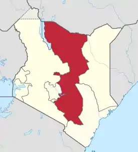 Location of the Former Province in Kenya. | |
| Coordinates: 0°0′N 38°0′E | |
| Country | |
| No. of Counties: | 8 |
| Capital | Embu |
| Area | |
| • Total | 140,698.6 km2 (54,324.0 sq mi) |
| Population (2009) | |
| • Total | 5,668,123[1] |
| Time zone | UTC+3 (EAT) |
Overview
On 16 July 2009, the province was sub-divided into 3 Sub-Provinces namely lower eastern with Machakos as headquarters, central eastern with Meru as headquarters, and upper eastern with Marsabit as headquarters; however those changes never took effect due to the political wrangles in the Kenyan coalition government at the time. The sub-division of provinces were carried out in all seven Provinces of Kenya, excluding Nairobi. As of March 2013 after the Kenyan general election, 2013, the Eastern Province was subdivided into 8 counties namely:
| Code | County | Former Province | Area (km2) | Population Census 2009 | Capital |
|---|---|---|---|---|---|
| 10 | Marsabit | Eastern | 66,923.1 | 291,166 | Marsabit |
| 11 | Isiolo | Eastern | 25,336.1 | 143,294 | Isiolo |
| 12 | Meru | Eastern | 7,003 | 1,356,301 | Meru |
| 13 | Tharaka-Nithi | Eastern | 2,609.5 | 365,330 | Chuka |
| 14 | Embu | Eastern | 2,555.9 | 516,212 | Embu |
| 15 | Kitui | Eastern | 24,385.1 | 1,012,709 | Kitui |
| 16 | Machakos | Eastern | 5,952.9 | 1,098,584 | Machakos |
| 17 | Makueni | Eastern | 8,008.9 | 884,527 | Wote |
| Totals | 140,698.6 | 5,668,123 | - |
The province was principally inhabited by the Meru, Kamba and Embu and several pastoralist communities. In 1979 its population was 2.7 million; in 1999, 4,631,779 (according to the 1999 census) and in 2009 the province would have had a population of 5,668,123.[2] In terms of area, it was the second largest province at (140,698.6 km2) in Kenya.
Geography
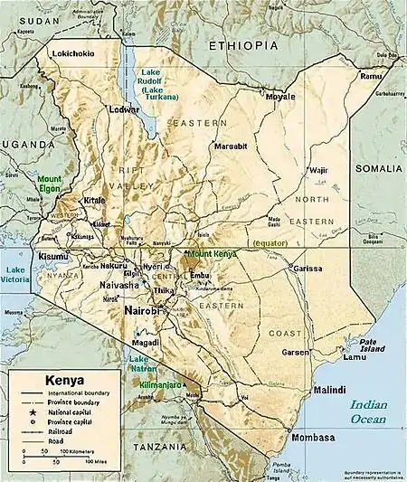
Eastern Province of Kenya includes the Chalbi Desert, Mount Kenya, and the eastern half of Lake Turkana. The climate in the region is arid to semi-arid. Its most important permanent river is Ewaso Ng'iro.
Villages and settlements
- Beacon Ranch
- Chematu
- Chiakariga
- Chiananda
- Chomboni
- Ekarakara
- El Dera
- Embori Farm
- Gakwegore
- Gariba
- Gatundori
- Gatunga
- Gekuuri
- Gethemu
- Gitare
- Ianzoni
- Iiuni
- Ikarakara
- Ikoo
- Imale
- Inghi Farm
- Inyokoni
- Isuvya
- Itetani
- Ithemboni
- Ithoku
- Itugururu
- Janoni
- Kaathene
- Kakunike
- Kakunio
- Kailembwa
- Kairuri
- Kakalia
- Kakangani
- Kalimbui
- Kalulini
- Kamaende
- Kampi-Ya-Chumvi
- Kambi ya Munyu
- Kampi Ya Juu
- Kampi Ya Sheikh Omar
- Kamuthwa
- Kaningo
- Kanjuki
- Kanyekine
- Karingare
- Karuamgi
- Karuari
- Kasafari
- Kasaini
- Kasilia
- Kasiokoni
- Katelembu
- Katene
- Kathangarari
- Kathangari
- Katheka
- Kathenaugi
- Kathugu
- Kathungu
- Katothia
- Katulye
- Katumani Experimental Farm
- Kavyongo
- Kawanjaro
- Kawelu
- Kegaa
- Kenplains
- Kerie
- Kevanda
- Kevote
- Kiakanyinga
- Kiamuringa
- Kiangungi
- Kianiai
- Kianiokoma
- Kianjuki
- Kiatineni
- Kibogi
- Kibugwa
- Kijegge
- Kikuu
- Kilawa
- Kimuu
- Kinyata Grazing Area
- Kirimari
- Kiritiri
- Kitandi
- Kithangathini
- Kitheine
- Kithunguri
- Kitoo
- Kitute
- Kivumbu
- Komboyoo
- Kubi Turkana
- Kwakavisi
- Kwandeke
- Kwa Kitau
- Kwa Makuli
- Kwa Ukungu
- Log Logo
- Lolomarik Farm
- Mado Yaka
- Maikuu
- Maiyuni
- Makabete
- Makenge
- Makinya
- Malibani
- Malima
- Malka Mari
- Mandongoi
- Mangelete
- Manoni
- Mapepie
- Masimbani
- Masongoleni
- Mavindu
- Mbevoni
- Mbuvu
- Mitembuka
- Mitungugu
- Mkapuwanzee
- Mubuko
- Muchiene
- Muchumo
- Muringari
- Mushamba
- Musikio
- Mutulia
- Mutune
- Mwangareme
- Mwangini
- Mwambathana
- Mwe
- Mwewe
- Ndooa
- Nembure
- Nchimwani
- Ngandani
- Ngandure
- Ngare Ndare Farm
- Ngathune
- Ngosini East
- Ngosini West
- Ngovie
- Ngusishi Farm
- Nguuni
- Ngwate
- Saricho
- Simba Ranch
- Skwata
- Syumbungu
- Usueni
See also
References
- "Archived copy". Archived from the original on 2013-07-29. Retrieved 2013-06-30.CS1 maint: archived copy as title (link)
- "Kenya Census 2009".