Elk Township, New Jersey
Elk Township is a township in Gloucester County, New Jersey, United States. As of the 2010 United States Census, the township's population was 4,216,[8][9][10] reflecting an increase of 702 (+20.0%) from the 3,514 counted in the 2000 Census, which had in turn declined by 292 (-7.7%) from the 3,806 counted in the 1990 Census.[18]
Elk Township, New Jersey | |
|---|---|
| Township of Elk | |
 Entering Elk Township along County Route 609 | |
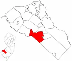 Elk Township highlighted in Gloucester County. Inset map: Gloucester County highlighted in the State of New Jersey. | |
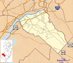
 Census Bureau map of Elk Township, New Jersey | |
 Elk Township Location in Gloucester County  Elk Township Location in New Jersey  Elk Township Location in the United States | |
| Coordinates: 39.662752°N 75.156972°W[1][2] | |
| Country | |
| State | |
| County | |
| Incorporated | April 17, 1891 |
| Government | |
| • Type | Township |
| • Body | Township Committee |
| • Mayor | Carolyn D. King-Sammons (R, term ends December 31, 2020)[4][5] |
| • Municipal clerk | Debbie Pine[6] |
| Area | |
| • Total | 19.34 sq mi (50.08 km2) |
| • Land | 19.16 sq mi (49.61 km2) |
| • Water | 0.18 sq mi (0.47 km2) 0.93% |
| Area rank | 145th of 565 in state 6th of 24 in county[1] |
| Elevation | 144 ft (44 m) |
| Population | |
| • Total | 4,216 |
| • Estimate (2019)[11] | 4,173 |
| • Rank | 405th of 566 in state 18th of 24 in county[12] |
| • Density | 216.3/sq mi (83.5/km2) |
| • Density rank | 499th of 566 in state 23rd of 24 in county[12] |
| Time zone | UTC−05:00 (Eastern (EST)) |
| • Summer (DST) | UTC−04:00 (Eastern (EDT)) |
| ZIP Code | 08343 - Monroeville[13] |
| Area code(s) | 856[14] |
| FIPS code | 3401521060[1][15][16] |
| GNIS feature ID | 0882139[1][17] |
| Website | www |
Elk Township was formed as a township by an act of the New Jersey Legislature on April 17, 1891, from portions of Clayton Township, Glassboro Township and South Harrison Township.[19] The township was named for elk hunted in the area.[20]
Until 2016, Elk Township had been a dry township where alcohol could not be sold.[21][22] That year, the township sold a package goods license for $300,000, which allows the sale of alcohol for off-premise consumption.[23]
Geography
According to the United States Census Bureau, the township had a total area of 19.34 square miles (50.08 km2), including 19.16 square miles (49.61 km2) of land and 0.18 square miles (0.47 km2) of water (0.93%).[1][2]
Unincorporated communities, localities and place names located partially or completely within the township include Aura, Ferrell, Harding, Hardingville and Monroeville.[24]
The township borders the municipalities of Clayton, Franklin Township, Glassboro, Harrison Township and South Harrison Township in Gloucester County; and Upper Pittsgrove Township in Salem County.[25][26]
Demographics
| Historical population | |||
|---|---|---|---|
| Census | Pop. | %± | |
| 1900 | 997 | — | |
| 1910 | 1,022 | 2.5% | |
| 1920 | 951 | −6.9% | |
| 1930 | 1,623 | 70.7% | |
| 1940 | 1,656 | 2.0% | |
| 1950 | 2,074 | 25.2% | |
| 1960 | 2,635 | 27.0% | |
| 1970 | 2,707 | 2.7% | |
| 1980 | 3,187 | 17.7% | |
| 1990 | 3,806 | 19.4% | |
| 2000 | 3,514 | −7.7% | |
| 2010 | 4,216 | 20.0% | |
| 2019 (est.) | 4,173 | [11][27] | −1.0% |
| Population sources: 1900-2000[28] 1900-1920[29] 1900-1910[30] 1910-1930[31] 1930-1990[32] 2000[33][34] 2010[8][9][10] | |||
Census 2010
The 2010 United States Census counted 4,216 people, 1,474 households, and 1,117 families in the township. The population density was 216.3 per square mile (83.5/km2). There were 1,576 housing units at an average density of 80.8 per square mile (31.2/km2). The racial makeup was 79.74% (3,362) White, 14.78% (623) Black or African American, 0.52% (22) Native American, 0.64% (27) Asian, 0.00% (0) Pacific Islander, 1.71% (72) from other races, and 2.61% (110) from two or more races. Hispanic or Latino of any race were 5.10% (215) of the population.[8]
Of the 1,474 households, 30.3% had children under the age of 18; 59.1% were married couples living together; 11.3% had a female householder with no husband present and 24.2% were non-families. Of all households, 17.9% were made up of individuals and 8.3% had someone living alone who was 65 years of age or older. The average household size was 2.81 and the average family size was 3.20.[8]
23.8% of the population were under the age of 18, 8.8% from 18 to 24, 24.8% from 25 to 44, 30.6% from 45 to 64, and 12.0% who were 65 years of age or older. The median age was 39.6 years. For every 100 females, the population had 95.9 males. For every 100 females ages 18 and older there were 96.8 males.[8]
The Census Bureau's 2006-2010 American Community Survey showed that (in 2010 inflation-adjusted dollars) median household income was $63,194 (with a margin of error of +/- $18,724) and the median family income was $74,412 (+/- $15,399). Males had a median income of $56,786 (+/- $16,223) versus $39,900 (+/- $15,570) for females. The per capita income for the borough was $27,707 (+/- $3,616). About 9.3% of families and 11.3% of the population were below the poverty line, including 8.8% of those under age 18 and 9.2% of those age 65 or over.[35]
Census 2000
As of the 2000 United States Census[15] there were 3,514 people, 1,263 households, and 958 families residing in the township. The population density was 179.0 people per square mile (69.1/km2). There were 1,347 housing units at an average density of 68.6 per square mile (26.5/km2). The racial makeup of the township was 82.07% White, 14.26% African American, 0.57% Native American, 0.43% Asian, 1.37% from other races, and 1.31% from two or more races. Hispanic or Latino of any race were 2.93% of the population.[33][34]
There were 1,263 households, out of which 33.8% had children under the age of 18 living with them, 59.9% were married couples living together, 11.4% had a female householder with no husband present, and 24.1% were non-families. 19.6% of all households were made up of individuals, and 8.9% had someone living alone who was 65 years of age or older. The average household size was 2.74 and the average family size was 3.16.[33][34]
In the township the population was spread out, with 27.2% under the age of 18, 6.9% from 18 to 24, 28.4% from 25 to 44, 24.9% from 45 to 64, and 12.6% who were 65 years of age or older. The median age was 38 years. For every 100 females, there were 96.1 males. For every 100 females age 18 and over, there were 92.6 males.[33][34]
The median income for a household in the township was $51,047, and the median income for a family was $55,472. Males had a median income of $41,604 versus $27,407 for females. The per capita income for the township was $18,621. About 8.3% of families and 8.5% of the population were below the poverty line, including 6.4% of those under age 18 and 15.7% of those age 65 or over.[33][34]
Government
Local government
Elk Township is governed under the Township form of New Jersey municipal government, one of 141 municipalities (of the 565) statewide that use this form, the second-most commonly used form of government in the state.[36] The Township Committee is comprised of five members, who are elected directly by the voters at-large in partisan elections to serve three-year terms of office on a staggered basis, with either one or two seats coming up for election each year as part of the November general election in a three-year cycle.[3][37] At an annual reorganization meeting, the Township Committee selects one of its members to serve as Mayor and another as Deputy Mayor.
As of 2020, the members of the Elk Township Committee are Mayor Carolyn King-Sammons (R, term on committee and as mayor ends December 31, 2020), Deputy Mayor Donna M. Nicholson (R, term on committee ends 2021; term as deputy mayor ends 2020), Thomas Hollywood Jr. (R, 2022), Edward Poisker (D, 2021), James Rambo (D, 2020).[4][38][39][40][41][42]
After the November 2014 general election, Elk Township Republicans declined to file for a recount with John J. Norris coming in third place (with 672 votes), six votes behind Republican Carolyn D. King-Sammons (678) and Democrat James Rambo (685).[43]
Federal, state and county representation
Elk Township is located in the 2nd Congressional District[44] and is part of New Jersey's 3rd state legislative district.[9][45][46]
For the 116th United States Congress, New Jersey's Second Congressional District is represented by Jeff Van Drew (R, Dennis Township).[47] New Jersey is represented in the United States Senate by Democrats Cory Booker (Newark, term ends 2021)[48] and Bob Menendez (Paramus, term ends 2025).[49][50]
For the 2018–2019 session (Senate, General Assembly), the 3rd Legislative District of the New Jersey Legislature is represented in the State Senate by Stephen M. Sweeney (D, West Deptford Township) and in the General Assembly by John J. Burzichelli (D, Paulsboro) and Adam Taliaferro (D, Woolwich Township).[51][52]
Gloucester County is governed by a Board of Chosen Freeholders, whose seven members are elected at-large to three-year terms of office on a staggered basis in partisan elections, with two or three seats coming up for election each year. At a reorganization meeting held each January, the Board selects a Freeholder Director and a Deputy Freeholder Director from among its members. As of 2020, Gloucester County's Freeholders are Freeholder Director Robert M. Damminger (D, West Deptford Township; 2021),[53] Deputy Freeholder Director Frank J. DiMarco (D, Deptford Township; 2022),[54] Lyman J. Barnes (D, Logan Township; 2020),[55] Daniel Christy (D, Washington Township; 2022),[56] Jim Jefferson (D, Woodbury; 2020),[57] Jim Lavender (D, Woolwich Township; 2021),[58] and Heather Simmons (D, Glassboro; 2020).[59][60]
Constitutional officers elected countywide are: County Clerk James N. Hogan (D, Franklinville in Franklin Township; 5-year term ends 2022),[61][62][63] Sheriff Carmel Morina (D, Greenwich Township; 3-year term ends 2021)[64][65][66] and Surrogate Giuseppe "Joe" Chila (D, Woolwich Township; 5-year term ends 2022).[67][68][69][63][70][66]
Politics
As of March 23, 2011, there were a total of 3,005 registered voters in Elk, of which 1,031 (34.3%) were registered as Democrats, 604 (20.1%) were registered as Republicans and 1,369 (45.6%) were registered as Unaffiliated. There was one voter registered to another party.[71]
In the 2012 presidential election, Democrat Barack Obama received 51.2% of the vote (1,116 cast), ahead of Republican Mitt Romney with 47.6% (1,039 votes), and other candidates with 1.2% (26 votes), among the 2,201 ballots cast by the township's 3,208 registered voters (20 ballots were spoiled), for a turnout of 68.6%.[72][73] In the 2008 presidential election, Democrat Barack Obama received 51.3% of the vote (1,187 cast), ahead of Republican John McCain with 46.7% (1,080 votes) and other candidates with 1.1% (25 votes), among the 2,312 ballots cast by the township's 3,204 registered voters, for a turnout of 72.2%.[74] In the 2004 presidential election, Republican George W. Bush received 50.9% of the vote (1,016 ballots cast), outpolling Democrat John Kerry with 47.8% (955 votes) and other candidates with 0.5% (14 votes), among the 1,997 ballots cast by the township's 2,727 registered voters, for a turnout percentage of 73.2.[75]
In the 2013 gubernatorial election, Republican Chris Christie received 65.7% of the vote (962 cast), ahead of Democrat Barbara Buono with 33.1% (484 votes), and other candidates with 1.2% (18 votes), among the 1,503 ballots cast by the township's 3,083 registered voters (39 ballots were spoiled), for a turnout of 48.8%.[76][77] In the 2009 gubernatorial election, Republican Chris Christie received 50.7% of the vote (784 ballots cast), ahead of Democrat Jon Corzine with 39.2% (607 votes), Independent Chris Daggett with 7.2% (112 votes) and other candidates with 0.8% (12 votes), among the 1,547 ballots cast by the township's 3,105 registered voters, yielding a 49.8% turnout.[78]
Education
The Elk Township School District serves students in public school for pre-kindergarten through sixth grade at Aura School, which was built in 1927, with the newest addition built in 2002.[79][80][81] As of the 2017–18 school year, the district, comprised of one school, had an enrollment of 379 students and 33.0 classroom teachers (on an FTE basis), for a student–teacher ratio of 11.5:1.[82]
For seventh through twelfth grades, public school students attend the Delsea Regional School District, which serves students from both Elk Township and Franklin Township.[83][84] Students from Newfield attend the district as part of a sending/receiving relationship begun in September 2010 after Newfield ended its prior relationship with the Buena Regional School District.[85] Schools in the district (with 2017-18 enrollment data from the National Center for Education Statistics[86]) are Delsea Regional Middle School[87] with 525 students in grades 7 and 8, and Delsea Regional High School[88] with 1,080 students in grades 9 - 12.[89][90][91] The seats on the high school district's nine-member board of education are allocated to the constituent municipalities based on population, with two seats assigned to Elk Township.[92]
The New Jersey Department of Education has considered a vote by the Board of Education of the Franklin Township Public Schools in June 2010 requesting that the district withdraw from the Delsea Regional School District, which would require that the Delsea region be dissolved as about 80% of the regional district's students come from Franklin. With the withdrawal of Franklin Township, two options being considered were to either have Franklin and Elk Townships create a new regional district with Newfield students attending on a send-receive basis, or having Franklin Township establish its own PreK-12 district which would receive students from both Elk Township and Newfield.[93][94]
Students from across the county are eligible to apply to attend Gloucester County Institute of Technology, a four-year high school in Deptford Township that provides technical and vocational education. As a public school, students do not pay tuition to attend the school.[95]
Transportation
_just_south_of_Exit_45_(Gloucester_County_Route_553%252C_Centerton%252C_Clayton%252C_Glassboro)_in_Elk_Township%252C_Gloucester_County%252C_New_Jersey.jpg.webp)
Roads and highways
As of May 2010, the township had a total of 66.75 miles (107.42 km) of roadways, of which 26.51 miles (42.66 km) were maintained by the municipality, 32.61 miles (52.48 km) by Gloucester County and 7.63 miles (12.28 km) by the New Jersey Department of Transportation.[96]
Major state routes that pass through include Route 77[97] and the limited access Route 55.[98] The two main county routes that are accessible include Route 538 and Route 553. The New Jersey Turnpike passes through in neighboring Harrison, but the closest exit is two towns away.
Public transportation
NJ Transit offers bus service on the 410 route between Bridgeton and Philadelphia.[99][100]
Notable people
People who were born in, residents of, or otherwise closely associated with Elk Township include:
- Sean F. Dalton (born 1962), member of the New Jersey General Assembly.[101]
References
- 2019 Census Gazetteer Files: New Jersey Places, United States Census Bureau. Accessed July 1, 2020.
- US Gazetteer files: 2010, 2000, and 1990, United States Census Bureau. Accessed September 4, 2014.
- 2012 New Jersey Legislative District Data Book, Rutgers University Edward J. Bloustein School of Planning and Public Policy, March 2013, p. 19.
- Township Committee, Elk Township. Accessed March 3, 2020.
- 2020 New Jersey Mayors Directory, New Jersey Department of Community Affairs. Accessed February 1, 2020.
- Municipal Clerk, Elk Township. Accessed April 1, 2020.
- U.S. Geological Survey Geographic Names Information System: Township of Elk, Geographic Names Information System. Accessed March 5, 2013.
- DP-1 - Profile of General Population and Housing Characteristics: 2010 for Elk township, Gloucester County, New Jersey Archived February 12, 2020, at Archive.today, United States Census Bureau. Accessed November 7, 2012.
- Municipalities Sorted by 2011-2020 Legislative District, New Jersey Department of State. Accessed February 1, 2020.
- Profile of General Demographic Characteristics: 2010 for Elk township Archived 2016-03-04 at the Wayback Machine, New Jersey Department of Labor and Workforce Development. Accessed November 7, 2012.
- Annual Estimates of the Resident Population for Minor Civil Divisions in New Jersey: April 1, 2010 to July 1, 2019, United States Census Bureau. Accessed May 21, 2020.
- GCT-PH1 Population, Housing Units, Area, and Density: 2010 - State -- County Subdivision from the 2010 Census Summary File 1 for New Jersey Archived May 26, 2015, at Archive.today, United States Census Bureau. Accessed November 7, 2012.
- Look Up a ZIP Code for Monroeville, NJ, United States Postal Service. Accessed November 7, 2012.
- Area Code Lookup - NPA NXX for Monroeville, NJ, Area-Codes.com. Accessed September 7, 2014.
- U.S. Census website , United States Census Bureau. Accessed September 4, 2014.
- Geographic codes for New Jersey, Missouri Census Data Center. Accessed September 1, 2019.
- US Board on Geographic Names, United States Geological Survey. Accessed September 4, 2014.
- Table 7. Population for the Counties and Municipalities in New Jersey: 1990, 2000 and 2010, New Jersey Department of Labor and Workforce Development, February 2011. Accessed November 7, 2012.
- Snyder, John P. The Story of New Jersey's Civil Boundaries: 1606-1968, Bureau of Geology and Topography; Trenton, New Jersey; 1969. p. 138. Accessed October 25, 2012.
- Hutchinson, Viola L. The Origin of New Jersey Place Names, New Jersey Public Library Commission, May 1945. Accessed August 30, 2015.
- New Jersey Division of Alcoholic Beverage Control. New Jersey ABC list of dry towns (May 1, 2013)
- Giordano, Rita. "More towns catching liquor-license buzz; Moorestown considers ending its dry spell", The Philadelphia Inquirer, June 24, 2007. Accessed February 16, 2014.
- O'Brien, Kathleen. "What it means to be one of N.J.'s 32 'dry' towns", NJ Advance Media for NJ.com, December 21, 2016. Accessed August 2, 2017. "'You can't very well sell alcohol to the beavers and the squirrels,' said Debbie Pine, township clerk for Elk Township in Gloucester County. The township recently put its first consumption out to bid in a sealed bid auction - and got no takers. It did, however, sell its first package goods license for $300,033, which is why she described the town as 'kinda-sorta' dry."
- Locality Search, State of New Jersey. Accessed May 21, 2015.
- Municipalities within Gloucester County, NJ, Delaware Valley Regional Planning Commission. Accessed November 7, 2019.
- New Jersey Municipal Boundaries, New Jersey Department of Transportation. Accessed November 7, 2019.
- Census Estimates for New Jersey April 1, 2010 to July 1, 2019, United States Census Bureau. Accessed May 21, 2020.
- Barnett, Bob. "Population Data for Gloucester County Municipalities, 1800 - 2000, WestJersey.org, January 6, 2011. Accessed November 7, 2012.
- Compendium of censuses 1726-1905: together with the tabulated returns of 1905, New Jersey Department of State, 1906. Accessed October 9, 2013.
- Thirteenth Census of the United States, 1910: Population by Counties and Minor Civil Divisions, 1910, 1900, 1890, United States Census Bureau, p. 336. Accessed November 7, 2012.
- Fifteenth Census of the United States : 1930 - Population Volume I, United States Census Bureau, p. 716. Accessed November 7, 2012.
- New Jersey Resident Population by Municipality: 1930 - 1990, Workforce New Jersey Public Information Network. Accessed June 28, 2015.
- Census 2000 Profiles of Demographic / Social / Economic / Housing Characteristics for Elk township, New Jersey Archived 2007-07-11 at the Wayback Machine, United States Census Bureau. Accessed October 31, 2016.
- DP-1: Profile of General Demographic Characteristics: 2000 - Census 2000 Summary File 1 (SF 1) 100-Percent Data for Elk township, Gloucester County, New Jersey Archived February 12, 2020, at Archive.today, United States Census Bureau. Accessed November 7, 2012.
- DP03: Selected Economic Characteristics from the 2006-2010 American Community Survey 5-Year Estimates for Elk township, Gloucester County, New Jersey Archived February 12, 2020, at Archive.today, United States Census Bureau. Accessed November 7, 2012.
- Inventory of Municipal Forms of Government in New Jersey, Rutgers University Center for Government Studies, July 1, 2011. Accessed November 18, 2019.
- "Forms of Municipal Government in New Jersey", p. 7. Rutgers University Center for Government Studies. Accessed June 3, 2015.
- 2020 Municipal Data Sheet, Elk Township. Accessed April 1, 2020.
- Gloucester County 2019 Official Directory, Gloucester County, New Jersey. Accessed November 1, 2019.
- General Election November 5, 2019 Summary Report Unofficial Results, Gloucester County, New Jersey Clerk, November 12, 2019. Accessed January 1, 2020.
- General Election November 6, 2018 Summary Report Unofficial Results, Gloucester County, New Jersey Clerk, November 12, 2018. Accessed January 1, 2019.
- General Election November 7, 2017 Summary Report Unofficial Results, Gloucester County, New Jersey Clerk, November 14, 2017. Accessed January 1, 2018.
- Pritchett, Kristina. "Elk Township Republicans, Democrat decline to challenge election results", South Jersey Times, November 11, 2014. Accessed January 16, 2015. "Elk Township Republicans have decided not to pursue a recount after provisional ballots were counted and determined there wouldn't be a change in results, according to Republican Chairwoman Donna Nicholson.... Republican Carolyn D. King-Sammons (678) and Democrat James Rambo (685) defeated John J. Norris (672) and Spring (668) by a handful of votes, according to unofficial results updated with provisional ballots on Monday afternoon."
- Plan Components Report, New Jersey Redistricting Commission, December 23, 2011. Accessed February 1, 2020.
- 2019 New Jersey Citizen's Guide to Government, New Jersey League of Women Voters. Accessed October 30, 2019.
- Districts by Number for 2011-2020, New Jersey Legislature. Accessed January 6, 2013.
- Directory of Representatives: New Jersey, United States House of Representatives. Accessed January 3, 2019.
- About Cory Booker, United States Senate. Accessed January 26, 2015. "He now owns a home and lives in Newark's Central Ward community."
- Biography of Bob Menendez, United States Senate, January 26, 2015. "He currently lives in Paramus and has two children, Alicia and Robert."
- Senators of the 116th Congress from New Jersey. United States Senate. Accessed April 17, 2019. "Booker, Cory A. - (D - NJ) Class II; Menendez, Robert - (D - NJ) Class I"
- Legislative Roster 2018-2019 Session, New Jersey Legislature. Accessed January 21, 2018.
- District 3 Legislators, New Jersey Legislature. Accessed January 22, 2018.
- Robert M. Damminger, Gloucester County, New Jersey. Accessed February 11, 2020.
- Frank J. DiMarco, Gloucester County, New Jersey. Accessed February 11, 2020.
- Lyman Barnes, Gloucester County, New Jersey. Accessed February 11, 2020.
- Daniel Christy, Gloucester County, New Jersey. Accessed February 11, 2020.
- Jim Jefferson, Gloucester County, New Jersey. Accessed February 11, 2020.
- Jim Lavender, Gloucester County, New Jersey. Accessed February 11, 2020.
- Heather Simmons, Gloucester County, New Jersey. Accessed February 11, 2020.
- Board of Freeholders, Gloucester County, New Jersey. Accessed February 11, 2020.
- James N. Hogan, Gloucester County. Accessed February 11, 2020.
- Members List: Clerks, Constitutional Officers Association of New Jersey. Accessed February 11, 2020.
- 2017 Gloucester County Election Results, Office of the Gloucester County Clerk. Accessed February 11, 2020.
- Sheriff Carmel M. Morina, Gloucester County. Accessed February 11, 2020.
- Members List: Sheriffs, Constitutional Officers Association of New Jersey. Accessed February 11, 2020.
- 2018 Gloucester County Election Results, Office of the Gloucester County Clerk. Accessed February 11, 2020.
- Surrogate Giuseppe Chila, Gloucester County. Accessed February 11, 2020.
- Members List: Surrogates, Constitutional Officers Association of New Jersey. Accessed February 11, 2020.
- Row Officers, Gloucester County, New Jersey. Accessed February 11, 2020.
- Helene Reed Dies, New Jersey Globe, April 28, 2018. Accessed February 11, 2020.
- Voter Registration Summary - Gloucester, New Jersey Department of State Division of Elections, March 23, 2011. Accessed November 7, 2012.
- "Presidential General Election Results - November 6, 2012 - Gloucester County" (PDF). New Jersey Department of Elections. March 15, 2013. Retrieved December 24, 2014.
- "Number of Registered Voters and Ballots Cast - November 6, 2012 - General Election Results - Gloucester County" (PDF). New Jersey Department of Elections. March 15, 2013. Retrieved December 24, 2014.
- 2008 Presidential General Election Results: Gloucester County, New Jersey Department of State Division of Elections, December 23, 2008. Accessed November 7, 2012.
- 2004 Presidential Election: Gloucester County, New Jersey Department of State Division of Elections, December 13, 2004. Accessed November 7, 2012.
- "Governor - Gloucester County" (PDF). New Jersey Department of Elections. January 29, 2014. Retrieved December 24, 2014.
- "Number of Registered Voters and Ballots Cast - November 5, 2013 - General Election Results - Gloucester County" (PDF). New Jersey Department of Elections. January 29, 2014. Retrieved December 24, 2014.
- 2009 Governor: Gloucester County Archived 2012-10-17 at the Wayback Machine, New Jersey Department of State Division of Elections, December 31, 2009. Accessed November 7, 2012.
- Township of Elk Board of Education Policy 0110 - Identification, Elk Township School District. Accessed April 1, 2020. "Purpose: The Board of Education exists for the purpose of providing a thorough and efficient system of free public education in grades Pre-K through 6 in the Elk Township School District. Composition: The Elk Township School District is comprised of all the area within the municipal boundaries of Elk Township."
- History of Elk Township Schools, Elk Township. Accessed January 5, 2017.
- 2016-17 Gloucester County Office of Education Public School Directory, Gloucester County, New Jersey. Accessed January 30, 2017.
- District information for Elk Township School District, National Center for Education Statistics. Accessed November 7, 2019.
- Delsea Regional Board of Education District Policy 0110 - Identification, Delsea Regional School District. Accessed April 1, 2020. "Purpose: The Board of Education exists for the purpose of providing a thorough and efficient system of free public education in grades 7 through 12 in the Delsea Regional High School District. Composition: The Delsea Regional High School District is comprised of all the area within the municipal boundaries of Elk Township and Franklin Township."
- 2019-2020 School Profile, Delsea Regional High School. Accessed November 10, 2019. "Delsea Regional High School serves the students of Franklin, Elk, and Newfield Townships."
- Romalino, Carly. "State OKs Newfield's break with Buena district", The Gloucester County Times, June 17, 2009. Accessed December 24, 2014. "In a phase-in process, according to Delsea Regional School District Superintendent Frank Borelli, Delsea schools will first accept Newfield students entering grades seven and nine in September 2010. Students entering grades 10, 11 and 12 as of September 2010 would continue to be educated at Buena High School."
- School Data for the Delsea Regional School District, National Center for Education Statistics. Accessed November 10, 2019.
- Delsea Regional Middle School, Delsea Regional School District. Accessed April 1, 2020.
- Delsea Regional High School, Delsea Regional School District. Accessed April 1, 2020.
- Schools, Delsea Regional School District. Accessed April 1, 2020.
- 2016-17 Gloucester County Office of Education Public School Directory, Gloucester County, New Jersey. Accessed April 1, 2020.
- New Jersey School Directory for the Delsea Regional School District, New Jersey Department of Education. Accessed December 29, 2016.
- Comprehensive Annual Financial Report of the Delsea Regional School District, New Jersey Department of Education, for year ending June 30, 2018. Accessed April 1, 2020. "The nine-member Board of Education is an elected body consisting of seven representatives from Franklin Township and two from Elk Township.... The Delsea Regional High School District is a Type II district located in the County of Gloucester, State of New Jersey. As a Type II District, the School District functions independently through a Board of Education. The Board is comprised of nine members elected to three-year terms."
- Bumpus, Robert L. "Report of the Interim Executive County Superintendent of Schools on the Withdrawal of Franklin Township School District from Delsea Regional School District, a Limited Purpose Regional School District", New Jersey Department of Education, March 30, 2012. Accessed September 8, 2013.
- Cooney, Joe. "Vote could end Delsea district; Franklin board seeks K-12 system", Asbury Park Press, July 13, 2012. Accessed December 24, 2014. "Franklin — The township's school board is seeking approval for a referendum that could lead to dissolution of the Delsea Regional School District. Franklin and Elk currently make up the regional district for students in grades 7 to 12. If a vote takes place, residents in those communities would decide on whether to create a new district for both municipalities' students in prekindergarten through 12th grade.... Newfield, which previously sent its kids to Buena Regional schools, now sends its students to Franklin and Delsea."
- Admissions, Gloucester County Institute of Technology. Accessed November 7, 2019. "There is no charge to attend. GCIT is a public school.... GCIT is the vocational-technical school for Gloucester County residents. You must live in Gloucester County to apply and attend."
- Gloucester County Mileage by Municipality and Jurisdiction, New Jersey Department of Transportation, May 2010. Accessed July 18, 2014.
- Route 77 Straight Line Diagram, New Jersey Department of Transportation, updated March 2017. Accessed November 7, 2019.
- Route 55 Straight Line Diagram, New Jersey Department of Transportation, updated March 2017. Accessed November 7, 2019.
- Gloucester County Bus / Rail Connections, NJ Transit, backed up by the Internet Archive as of July 26, 2010. Accessed November 6, 2012.
- Gloucester County's Transit Guide, Gloucester County, New Jersey. Accessed November 7, 2019.
- Assemblyman Sean F. Dalton, backed up by the Internet Archive as of February 5, 1997. Accessed June 17, 2010.
External links
| Wikimedia Commons has media related to Elk Township, New Jersey. |
- Elk Township official website
- Elk Township School District
- Elk Township School District's 2015–16 School Report Card from the New Jersey Department of Education
- School Data for the Elk Township School District, National Center for Education Statistics
- Delsea Regional School District
- Delsea Regional School District's 2015–16 School Report Card from the New Jersey Department of Education
- School Data for the Delsea Regional School District, National Center for Education Statistics
Municipalities and communities of Gloucester County, New Jersey, United States | ||
|---|---|---|
| City | 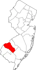 Map of New Jersey highlighting Gloucester County | |
| Boroughs | ||
| Townships | ||
| CDPs | ||
| Other unincorporated communities |
| |
| ||