Clayton, New Jersey
Clayton is a borough in Gloucester County, New Jersey, United States. As of the 2010 United States Census, the borough's population was 8,179,[9][10][11] reflecting an increase of 1,040 (+14.6%) from the 7,139 counted in the 2000 Census, which had in turn increased by 984 (+16.0%) from the 6,155 counted in the 1990 Census.[20]
Clayton, New Jersey | |
|---|---|
| Borough of Clayton | |
 Clayton High School | |
| Motto(s): "A great place to live and play to work and pray!" | |
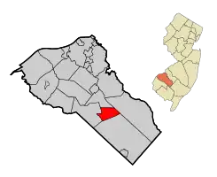 Map of Clayton highlighted within Gloucester County. Inset: Location of Gloucester County in New Jersey. | |
 Census Bureau map of Clayton, New Jersey | |
 Clayton Location in Gloucester County  Clayton Location in New Jersey  Clayton Location in the United States | |
| Coordinates: 39.663736°N 75.077505°W[1][2] | |
| Country | |
| State | |
| County | |
| Incorporated | February 5, 1858 (as township) |
| Reincorporated | May 9, 1887 (as borough) |
| Government | |
| • Type | Borough (New Jersey) |
| • Body | Borough Council |
| • Mayor | Thomas Bianco (D, term ends December 31, 2023)[4][5] |
| • Administrator | Susan Miller[6] |
| • Municipal clerk | Christine Newcomb[7] |
| Area | |
| • Total | 7.26 sq mi (18.80 km2) |
| • Land | 7.08 sq mi (18.32 km2) |
| • Water | 0.18 sq mi (0.48 km2) 2.53% |
| Area rank | 239th of 565 in state 15th of 24 in county[1] |
| Elevation | 121 ft (37 m) |
| Population | |
| • Total | 8,179 |
| • Estimate (2019)[12] | 8,738 |
| • Rank | 282nd of 566 in state 13th of 24 in county[13] |
| • Density | 1,145.5/sq mi (442.3/km2) |
| • Density rank | 362nd of 566 in state 13th of 24 in county[13] |
| Time zone | UTC−05:00 (Eastern (EST)) |
| • Summer (DST) | UTC−04:00 (Eastern (EDT)) |
| ZIP Code | |
| Area code(s) | 856 exchanges: 307, 442, 863, 881[16] |
| FIPS code | 3401513360[1][17][18] |
| GNIS feature ID | 0885185[1][19] |
| Website | www |
Jacob Fisler, who purchased much of the area that is now Clayton, acquired 6,500 acres (2,600 ha) of land after the American Revolutionary War. A settlement called Fislertown developed that had grown to 36 families by 1812.[21] The establishment of a glass factory in the 1850s by one of Fisler's descendants led to the growth of Fislertown.[22]
What is now Clayton was originally formed as Clayton Township, which was created on February 5, 1858, from portions of Franklin Township. Portions of the township were taken to form Glassboro Township on March 11, 1878. Clayton was formed as a borough by an act of the New Jersey Legislature on May 9, 1887, from portions of Clayton Township. The remainder of Clayton Township was absorbed by the Borough of Clayton on April 14, 1908, and the township was dissolved.[23]
Geography
According to the United States Census Bureau, the borough had a total area of 7.26 square miles (18.80 km2), including 7.08 square miles (18.32 km2) of land and 0.18 square miles (0.48 km2) of water (2.53%).[1][2]
Unincorporated communities, localities and place names located partially or completely within the borough include Silver Lake.[24]
Clayton borders Elk Township, Franklin Township, Glassboro and Monroe Township.[25][26]
Demographics
| Historical population | |||
|---|---|---|---|
| Census | Pop. | %± | |
| 1860 | 2,490 | — | |
| 1870 | 3,674 | 47.6% | |
| 1880 | 1,981 | −46.1% | |
| 1890 | 2,299 | 16.1% | |
| 1900 | 1,989 | −13.5% | |
| 1910 | 1,926 | −3.2% | |
| 1920 | 1,905 | −1.1% | |
| 1930 | 2,351 | 23.4% | |
| 1940 | 2,320 | −1.3% | |
| 1950 | 3,023 | 30.3% | |
| 1960 | 4,711 | 55.8% | |
| 1970 | 5,193 | 10.2% | |
| 1980 | 6,013 | 15.8% | |
| 1990 | 6,155 | 2.4% | |
| 2000 | 7,139 | 16.0% | |
| 2010 | 8,179 | 14.6% | |
| 2019 (est.) | 8,738 | [12][27][28] | 6.8% |
| Population sources: 1860-2000[29] 1860-1920[30] 1860-1870[31] 1870[32] 1880-1890[33] 1890-1910[34] 1910-1930[35] 1930-1990[36] 2000[37][38] 2010[9] | |||
Census 2010
The 2010 United States Census counted 8,179 people, 2,916 households, and 2,105 families in the borough. The population density was 1,145.5 per square mile (442.3/km2). There were 3,128 housing units at an average density of 438.1 per square mile (169.2/km2). The racial makeup was 74.83% (6,120) White, 18.01% (1,473) Black or African American, 0.37% (30) Native American, 1.80% (147) Asian, 0.02% (2) Pacific Islander, 1.59% (130) from other races, and 3.39% (277) from two or more races. Hispanic or Latino of any race were 5.95% (487) of the population.[9]
Of the 2,916 households, 34.1% had children under the age of 18; 51.4% were married couples living together; 14.7% had a female householder with no husband present and 27.8% were non-families. Of all households, 22.1% were made up of individuals and 8.7% had someone living alone who was 65 years of age or older. The average household size was 2.80 and the average family size was 3.27.[9]
26.3% of the population were under the age of 18, 8.2% from 18 to 24, 27.8% from 25 to 44, 27.5% from 45 to 64, and 10.2% who were 65 years of age or older. The median age was 36.2 years. For every 100 females, the population had 92.9 males. For every 100 females ages 18 and older there were 89.1 males.[9]
The Census Bureau's 2006-2010 American Community Survey showed that (in 2010 inflation-adjusted dollars) median household income was $70,299 (with a margin of error of +/- $5,649) and the median family income was $70,989 (+/- $5,101). Males had a median income of $52,048 (+/- $6,973) versus $39,524 (+/- $6,308) for females. The per capita income for the borough was $27,437 (+/- $2,649). About 9.6% of families and 11.7% of the population were below the poverty line, including 16.9% of those under age 18 and 8.0% of those age 65 or over.[39]
Census 2000
As of the 2000 United States Census[17] there were 7,139 people, 2,464 households, and 1,884 families residing in the borough. The population density was 994.2 people per square mile (383.9/km2). There were 2,680 housing units at an average density of 373.2 per square mile (144.1/km2). The racial makeup of the borough was 79.23% White, 16.05% African American, 0.42% Native American, 0.66% Asian, 0.03% Pacific Islander, 0.95% from other races, and 2.66% from two or more races. Hispanic or Latino of any race were 3.28% of the population.[37][38]
There were 2,464 households, out of which 39.4% had children under the age of 18 living with them, 57.5% were married couples living together, 13.9% had a female householder with no husband present, and 23.5% were non-families. 19.7% of all households were made up of individuals, and 7.5% had someone living alone who was 65 years of age or older. The average household size was 2.89 and the average family size was 3.31.[37][38]
In the borough the population was spread out, with 29.1% under the age of 18, 8.7% from 18 to 24, 31.6% from 25 to 44, 21.0% from 45 to 64, and 9.6% who were 65 years of age or older. The median age was 34 years. For every 100 females, there were 91.7 males. For every 100 females age 18 and over, there were 89.8 males.[37][38]
The median income for a household in the borough was $53,219, and the median income for a family was $63,097. Males had a median income of $37,231 versus $29,063 for females. The per capita income for the borough was $20,006. About 3.1% of families and 2.9% of the population were below the poverty line, including 4.0% of those under age 18 and 1.7% of those age 65 or over.[37][38]
Parks and recreation
Parkland covers about a third of the borough, including municipal and state parks.[40][41]
The Glassboro Wildlife Management Area covers almost 2,400 acres (970 ha) in portions of Clayton, Glassboro and Monroe Township.[42][43]
Government
Local government
Clayton is governed under the Borough form of New Jersey municipal government, which is used in 218 municipalities (of the 565) statewide, making it the most common form of government in New Jersey.[44] The governing body is comprised of a Mayor and a Borough Council, with all positions elected at-large on a partisan basis as part of the November general election. A Mayor is elected directly by the voters to a four-year term of office. The Borough Council is comprised of six members elected to serve three-year terms on a staggered basis, with two seats coming up for election each year in a three-year cycle.[3] The Borough form of government used by Clayton is a "weak mayor / strong council" government in which council members act as the legislative body with the mayor presiding at meetings and voting only in the event of a tie. The mayor can veto ordinances subject to an override by a two-thirds majority vote of the council. The mayor makes committee and liaison assignments for council members, and most appointments are made by the mayor with the advice and consent of the council.[45][46][47]
As of 2020, the Mayor of the Borough of Clayton is Democrat Thomas Bianco, whose term of office ends on December 31, 2023. Members of the Borough Council are Council President Tony Saban (D, 2022), Franklin Brown Jr. (D, 2021), Christina Moorhouse (D, 2022), Frank Rollo (D, 2021), Charles Simon (D, 2020) and Darlene Vondran (D, 2020).[4][48][49][50][51][52]
In March 2019, the Borough Council selected Christina Moorhouse from a list of three candidates nominated by the Democratic municipal committee to fill the seat expiring in December 2019 that had been held by Vonzora Jackson until she resigned from office.[53]
In 2016, Franklin Brown was appointed to replace Brian Bicking, serving a term of office expiring in December 2016.
Clayton describes itself in its motto as "a great place to live and play, work and pray." The seal, which has been used since the late 1960s, features an image of a factory, a house and a figure fishing off a boat, along with a church with a cross, which has been challenged by the Freedom From Religion Foundation in March 2016 as "unmistakably religious" and unconstitutional.[54][55]
Federal, state and county representation
Clayton is located in the 2nd Congressional District[56] and is part of New Jersey's 3rd state legislative district.[10][57][58]
For the 116th United States Congress, New Jersey's Second Congressional District is represented by Jeff Van Drew (R, Dennis Township).[59] New Jersey is represented in the United States Senate by Democrats Cory Booker (Newark, term ends 2021)[60] and Bob Menendez (Paramus, term ends 2025).[61][62]
For the 2018–2019 session (Senate, General Assembly), the 3rd Legislative District of the New Jersey Legislature is represented in the State Senate by Stephen M. Sweeney (D, West Deptford Township) and in the General Assembly by John J. Burzichelli (D, Paulsboro) and Adam Taliaferro (D, Woolwich Township).[63][64]
Gloucester County is governed by a Board of Chosen Freeholders, whose seven members are elected at-large to three-year terms of office on a staggered basis in partisan elections, with two or three seats coming up for election each year. At a reorganization meeting held each January, the Board selects a Freeholder Director and a Deputy Freeholder Director from among its members. As of 2020, Gloucester County's Freeholders are Freeholder Director Robert M. Damminger (D, West Deptford Township; 2021),[65] Deputy Freeholder Director Frank J. DiMarco (D, Deptford Township; 2022),[66] Lyman J. Barnes (D, Logan Township; 2020),[67] Daniel Christy (D, Washington Township; 2022),[68] Jim Jefferson (D, Woodbury; 2020),[69] Jim Lavender (D, Woolwich Township; 2021),[70] and Heather Simmons (D, Glassboro; 2020).[71][72]
Constitutional officers elected countywide are: County Clerk James N. Hogan (D, Franklinville in Franklin Township; 5-year term ends 2022),[73][74][75] Sheriff Carmel Morina (D, Greenwich Township; 3-year term ends 2021)[76][77][78] and Surrogate Giuseppe "Joe" Chila (D, Woolwich Township; 5-year term ends 2022).[79][80][81][75][82][78]
Politics
As of March 23, 2011, there were a total of 4,874 registered voters in Clayton, of which 1,755 (36.0%) were registered as Democrats, 819 (16.8%) were registered as Republicans and 2,296 (47.1%) were registered as Unaffiliated. There were 4 voters registered to other parties.[83]
In the 2012 presidential election, Democrat Barack Obama received 64.2% of the vote (2,247 cast), ahead of Republican Mitt Romney with 34.5% (1,206 votes), and other candidates with 1.3% (45 votes), among the 3,521 ballots cast by the borough's 5,164 registered voters (23 ballots were spoiled), for a turnout of 68.2%.[84][85] In the 2008 presidential election, Democrat Barack Obama received 62.1% of the vote (2,270 cast), ahead of Republican John McCain with 35.8% (1,309 votes) and other candidates with 1.3% (49 votes), among the 3,653 ballots cast by the borough's 5,090 registered voters, for a turnout of 71.8%.[86] In the 2004 presidential election, Democrat John Kerry received 54.5% of the vote (1,745 ballots cast), outpolling Republican George W. Bush with 44.6% (1,427 votes) and other candidates with 0.4% (16 votes), among the 3,201 ballots cast by the borough's 4,410 registered voters, for a turnout percentage of 72.6.[87]
In the 2013 gubernatorial election, Republican Chris Christie received 56.7% of the vote (1,133 cast), ahead of Democrat Barbara Buono with 41.9% (837 votes), and other candidates with 1.5% (30 votes), among the 2,039 ballots cast by the borough's 5,133 registered voters (39 ballots were spoiled), for a turnout of 39.7%.[88][89] In the 2009 gubernatorial election, Democrat Jon Corzine received 48.2% of the vote (1,055 ballots cast), ahead of Republican Chris Christie with 39.8% (871 votes), Independent Chris Daggett with 9.1% (200 votes) and other candidates with 0.8% (17 votes) among the 2,191 ballots cast by the borough's 4,947 registered voters, yielding a 44.3% turnout.[90]
Education
The Clayton Public Schools serve students in pre-kindergarten through twelfth grade.[91] As of the 2017–18 school year, the district, comprised of three schools, had an enrollment of 1,453 students and 115.5 classroom teachers (on an FTE basis), for a student–teacher ratio of 12.6:1.[92] Schools in the district (with 2017-18 enrollment data from the National Center for Education Statistics[93]) are Herma S. Simmons Elementary School[94] with 667 students in grades PreK-5, Clayton Middle School[95] with 345 students in grades 6-8 and Clayton High School[96] with 416 students in grades 9-12.[97][98]
In September 2009, voters approved a referendum that covered a $20 million renovation and expansion project at the middle school / high school.[99] In September 2014, voters approved a referendum that covered $9.7 million to upgrade all three schools in the district. The approved projects include a roof replacement at both the high school and middle school, an addition of a 750-seat auditorium, technology infrastructure at all three schools, a new football field stadium lighting and a new gym floor at Herma Simmons Elementary School.[100]
Students from across the county are eligible to apply to attend Gloucester County Institute of Technology, a four-year high school in Deptford Township that provides technical and vocational education programs. As a public school, students and their families do not pay tuition to attend the school.[101]
Formed as the result of the merger of two regional schools, St. Michael the Archangel Regional School is a K-8 school that operates under the supervision of the Roman Catholic Diocese of Camden.[102][103] The former St. Catherine of Siena Regional School in Clayton merged into St. Michael in 2008.[104]
Transportation
_just_north_of_Gloucester_County_Route_610_(Academy_Street)_in_Clayton%252C_Gloucester_County%252C_New_Jersey.jpg.webp)
Roads and highways
As of May 2010, the borough had a total of 44.16 miles (71.07 km) of roadways, of which 33.00 miles (53.11 km) were maintained by the municipality, 8.36 miles (13.45 km) by Gloucester County and 2.80 miles (4.51 km) by the New Jersey Department of Transportation.[105]
The main thoroughfare that passes through is Route 47.[106] Route 55 traverses in the southwestern edge briefly, but the closest interchanges are in neighboring communities.[107] A sliver of CR 553 clips the western edge of the borough.
Public transportation
NJ Transit bus service is available between the borough and Philadelphia on the 313 and 408 routes.[108][109]
Notable people
People who were born in, residents of, or otherwise closely associated with Clayton include:
- Daniel Dalton (born 1949), politician who served as New Jersey Senate Majority Leader and as Secretary of State of New Jersey.[110]
- Sunny Gale (born 1927), retired pop singer who had her biggest hit with a cover version of "Wheel of Fortune" in 1952.[111]
- Granger Hall (born 1962), former professional basketball player.[112]
- Earl C. Long (1883-1983), United States Marine Corps Major General during World War II who commanded Service Command, Fleet Marine Force Pacific.[113]
- Nick Rodriguez, submission grappler who competes in no-gi matches.[114]
- Mel Sheppard (1883-1942), middle-distance runner who won four gold medals at the 1908 Summer Olympics and 1912 Summer Olympics.[115]
References
- 2019 Census Gazetteer Files: New Jersey Places, United States Census Bureau. Accessed July 1, 2020.
- US Gazetteer files: 2010, 2000, and 1990, United States Census Bureau. Accessed September 4, 2014.
- 2012 New Jersey Legislative District Data Book, Rutgers University Edward J. Bloustein School of Planning and Public Policy, March 2013, p. 19.
- Mayor & Council, Borough of Clayton. Accessed March 24, 2020.
- 2020 New Jersey Mayors Directory, New Jersey Department of Community Affairs. Accessed February 1, 2020.
- Borough Administrator, Borough of Clayton. Accessed March 23, 2020.
- Borough Clerk / Registrar, Borough of Clayton. Accessed March 23, 2020.
- U.S. Geological Survey Geographic Names Information System: Borough of Clayton, Geographic Names Information System. Accessed March 5, 2013.
- DP-1 - Profile of General Population and Housing Characteristics: 2010 for Clayton borough, Gloucester County, New Jersey Archived February 12, 2020, at Archive.today, United States Census Bureau. Accessed November 6, 2012.
- Municipalities Sorted by 2011-2020 Legislative District, New Jersey Department of State. Accessed February 1, 2020.
- Profile of General Demographic Characteristics: 2010 for Clayton borough Archived 2014-09-01 at the Wayback Machine, New Jersey Department of Labor and Workforce Development. Accessed November 6, 2012.
- QuickFacts for Clayton borough, New Jersey; Gloucester County, New Jersey; New Jersey from Population estimates, July 1, 2019, (V2019), United States Census Bureau. Accessed May 21, 2020.
- GCT-PH1 Population, Housing Units, Area, and Density: 2010 - State -- County Subdivision from the 2010 Census Summary File 1 for New Jersey Archived February 12, 2020, at Archive.today, United States Census Bureau. Accessed November 6, 2012.
- Look Up a ZIP Code for Clayton, NJ, United States Postal Service. Accessed November 6, 2012.
- Zip Codes, State of New Jersey. Accessed October 8, 2013.
- Area Code Lookup - NPA NXX for Clayton, NJ, Area-Codes.com. Accessed October 8, 2013.
- U.S. Census website , United States Census Bureau. Accessed September 4, 2014.
- Geographic codes for New Jersey, Missouri Census Data Center. Accessed September 1, 2019.
- US Board on Geographic Names, United States Geological Survey. Accessed September 4, 2014.
- Table 7. Population for the Counties and Municipalities in New Jersey: 1990, 2000 and 2010, New Jersey Department of Labor and Workforce Development, February 2011. Accessed November 6, 2012.
- History of Clayton, Clayton Historical Society. Accessed November 7, 2019. "After the Revolutionary War, Jacob and his son Leonard jointly bought 3,755 acres, expanding Fisler territory from the land near the Clayton cemetery westward to Aura. Leonard built a home on this land by Still Run Creek, which is now called Silver Lake.... As their territory expanded in size, it also grew in population. More and more families moved to the area, and by 1812, thirty-six families had settled in Fisler Town."
- Borough History, Borough of Clayton. Accessed November 7, 2019. "Jacob Fisler purchased a tract of land containing 2,800 acres in the area of Clayton’s Cedar Green Cemetery. He and his son Leonard jointly purchased 3,755 acres extending from the cemetery to Aura. In 1850, the locality gradually took on the name of Fislertown, and consisted of five dwellings. Jacob Fisler and Benjamin Beckett opened a glass factory at this time, which was a catalyst for a significant increase in the population."
- Snyder, John P. The Story of New Jersey's Civil Boundaries: 1606-1968, Bureau of Geology and Topography; Trenton, New Jersey; 1969. p. 137. Accessed October 25, 2012.
- Locality Search, State of New Jersey. Accessed May 21, 2015.
- Municipalities within Gloucester County, NJ, Delaware Valley Regional Planning Commission. Accessed March 23, 2020.
- New Jersey Municipal Boundaries, New Jersey Department of Transportation. Accessed November 15, 2019.
- Annual Estimates of the Resident Population for Minor Civil Divisions in New Jersey: April 1, 2010 to July 1, 2019, United States Census Bureau. Accessed May 21, 2020.
- Census Estimates for New Jersey April 1, 2010 to July 1, 2019, United States Census Bureau. Accessed May 21, 2020.
- Barnett, Bob. Population Data for Gloucester County Municipalities, 1810 - 2010, WestJersey.org. January 6, 2011. Accessed November 6, 2012. As both Clayton Township and Clayton Borough co-existed, the population statistics for 1890 (1,807 for borough; 492 for township) and 1900 (1,951 for borough; 38 for township) reflect the combined totals for both municipalities.
- Compendium of censuses 1726-1905: together with the tabulated returns of 1905, New Jersey Department of State, 1906. Accessed October 8, 2013.
- Raum, John O. The History of New Jersey: From Its Earliest Settlement to the Present Time, Volume 1, p. 256, J. E. Potter and company, 1877. Accessed October 8, 2013. "Clayton township in 1860 contained a population of 2,490, and in 1870 3,674. This township was formed from Franklin in 1858."
- Staff. A compendium of the ninth census, 1870, p. 258. United States Census Bureau, 1872. Accessed October 8, 2013.
- Porter, Robert Percival. Preliminary Results as Contained in the Eleventh Census Bulletins: Volume III - 51 to 75, p. 98. United States Census Bureau, 1890. Accessed October 8, 2013. Population is listed for the whole township of 1,981 in 1880 and 2,299 in 1890, and for the borough within the township of 1,433 in 1880 1,807 in 1890.
- Thirteenth Census of the United States, 1910: Population by Counties and Minor Civil Divisions, 1910, 1900, 1890, United States Census Bureau, p. 336. Accessed November 6, 2012.
- Fifteenth Census of the United States : 1930 - Population Volume I, United States Census Bureau, p. 716. Accessed November 6, 2012.
- New Jersey Resident Population by Municipality: 1930 - 1990, Workforce New Jersey Public Information Network. Accessed June 28, 2015.
- Census 2000 Profiles of Demographic / Social / Economic / Housing Characteristics for Clayton borough, New Jersey Archived 2014-08-18 at the Wayback Machine, United States Census Bureau. Accessed November 6, 2012.
- DP-1: Profile of General Demographic Characteristics: 2000 - Census 2000 Summary File 1 (SF 1) 100-Percent Data for Clayton borough, Gloucester County, New Jersey Archived February 12, 2020, at Archive.today, United States Census Bureau. Accessed November 6, 2012.
- DP03: Selected Economic Characteristics from the 2006-2010 American Community Survey 5-Year Estimates for Clayton borough, Gloucester County, New Jersey Archived February 12, 2020, at Archive.today, United States Census Bureau. Accessed November 6, 2012.
- Clayton Parks, Borough of Clayton. Accessed November 7, 2019. "The Borough of Clayton is fortunate to have approximately one-third of its land dedicated to parks and recreation."
- Watershed Based Municipal Stormwater Management Plan for Clayton Borough, Clayton Borough, February 2006. Accessed March 24, 2020. "With its small land area, its location between Philadelphia and the New Jersey Shore, and its major highway access (in particular, Routes 47 and 55), it is likely that Clayton Borough will someday experience significant development pressures. However, more than one-third of the small Borough is comprised of wildlife management areas, lakes and parks."
- Glassboro Wildlife Management Area, New Jersey Division of Fish and Wildlife. Accessed November 7, 2019.
- Wildlife Management Areas, New Jersey Division of Fish and Wildlife. Accessed November 7, 2019.
- Inventory of Municipal Forms of Government in New Jersey, Rutgers University Center for Government Studies, July 1, 2011. Accessed November 18, 2019.
- Cerra, Michael F. "Forms of Government: Everything You've Always Wanted to Know, But Were Afraid to Ask" Archived 2014-09-24 at the Wayback Machine, New Jersey State League of Municipalities. Accessed November 30, 2014.
- "Forms of Municipal Government in New Jersey", p. 6. Rutgers University Center for Government Studies. Accessed June 3, 2015.
- Government Archived August 26, 2014, at the Wayback Machine, Borough of Clayton. Accessed July 5, 2016.
- 2019 Municipal User Friendly Budget, Borough of Clayton. Accessed November 7, 2019.
- Gloucester County 2019 Official Directory, Gloucester County, New Jersey. Accessed November 1, 2019.
- General Election November 5, 2019 Summary Report Unofficial Results, Gloucester County, New Jersey Clerk, November 12, 2019. Accessed January 1, 2020.
- General Election November 6, 2018 Summary Report Unofficial Results, Gloucester County, New Jersey Clerk, November 12, 2018. Accessed January 1, 2019.
- General Election November 7, 2017 Summary Report Unofficial Results, Gloucester County, New Jersey Clerk, November 14, 2017. Accessed January 1, 2018.
- Staff. "New Council & School Board Members Installed; With Resignations Come New Appointments", Clayton Free Press, March 2019. Accessed November 7, 2019. "On Clayton Borough Council, with the resignation of Vonzora (Vonnie) Jackson, Christina Moorhouse was selected from a list of three people recommended to Council by the Clayton Democratic Party."
- Polhamus, Andy. "Is this N.J. town's seal too religious? An atheist group thinks so", NJ.com, April 4, 2016. Accessed April 4, 2016. "A national atheist group is asking the borough to change both its town motto and official seal, saying that both are 'unmistakably religious' and unconstitutional. Clayton's motto describes the town as 'a great place to live and play, work and pray.' The seal, meanwhile features an image of a church emblazoned with a cross as well as a factory, a house and a figure fishing from a boat."
- Editorial Board. "N.J. town's 'cross' seal does not offend - Editorial", South Jersey Times, April 4, 2016. Accessed April 5, 2016. "The church building, with a cross within, is one of five stylized elements in the seal. Others include an industrial building and a person fishing from a boat."
- Plan Components Report, New Jersey Redistricting Commission, December 23, 2011. Accessed February 1, 2020.
- 2019 New Jersey Citizen's Guide to Government, New Jersey League of Women Voters. Accessed October 30, 2019.
- Districts by Number for 2011-2020, New Jersey Legislature. Accessed January 6, 2013.
- Directory of Representatives: New Jersey, United States House of Representatives. Accessed January 3, 2019.
- About Cory Booker, United States Senate. Accessed January 26, 2015. "He now owns a home and lives in Newark's Central Ward community."
- Biography of Bob Menendez, United States Senate, January 26, 2015. "He currently lives in Paramus and has two children, Alicia and Robert."
- Senators of the 116th Congress from New Jersey. United States Senate. Accessed April 17, 2019. "Booker, Cory A. - (D - NJ) Class II; Menendez, Robert - (D - NJ) Class I"
- Legislative Roster 2018-2019 Session, New Jersey Legislature. Accessed January 21, 2018.
- District 3 Legislators, New Jersey Legislature. Accessed January 22, 2018.
- Robert M. Damminger, Gloucester County, New Jersey. Accessed February 11, 2020.
- Frank J. DiMarco, Gloucester County, New Jersey. Accessed February 11, 2020.
- Lyman Barnes, Gloucester County, New Jersey. Accessed February 11, 2020.
- Daniel Christy, Gloucester County, New Jersey. Accessed February 11, 2020.
- Jim Jefferson, Gloucester County, New Jersey. Accessed February 11, 2020.
- Jim Lavender, Gloucester County, New Jersey. Accessed February 11, 2020.
- Heather Simmons, Gloucester County, New Jersey. Accessed February 11, 2020.
- Board of Freeholders, Gloucester County, New Jersey. Accessed February 11, 2020.
- James N. Hogan, Gloucester County. Accessed February 11, 2020.
- Members List: Clerks, Constitutional Officers Association of New Jersey. Accessed February 11, 2020.
- 2017 Gloucester County Election Results, Office of the Gloucester County Clerk. Accessed February 11, 2020.
- Sheriff Carmel M. Morina, Gloucester County. Accessed February 11, 2020.
- Members List: Sheriffs, Constitutional Officers Association of New Jersey. Accessed February 11, 2020.
- 2018 Gloucester County Election Results, Office of the Gloucester County Clerk. Accessed February 11, 2020.
- Surrogate Giuseppe Chila, Gloucester County. Accessed February 11, 2020.
- Members List: Surrogates, Constitutional Officers Association of New Jersey. Accessed February 11, 2020.
- Row Officers, Gloucester County, New Jersey. Accessed February 11, 2020.
- Helene Reed Dies, New Jersey Globe, April 28, 2018. Accessed February 11, 2020.
- Voter Registration Summary - Gloucester, New Jersey Department of State Division of Elections, March 23, 2011. Accessed November 6, 2012.
- "Presidential General Election Results - November 6, 2012 - Gloucester County" (PDF). New Jersey Department of Elections. March 15, 2013. Retrieved December 24, 2014.
- "Number of Registered Voters and Ballots Cast - November 6, 2012 - General Election Results - Gloucester County" (PDF). New Jersey Department of Elections. March 15, 2013. Retrieved December 24, 2014.
- 2008 Presidential General Election Results: Gloucester County, New Jersey Department of State Division of Elections, December 23, 2008. Accessed November 6, 2012.
- 2004 Presidential Election: Gloucester County, New Jersey Department of State Division of Elections, December 13, 2004. Accessed November 6, 2012.
- "Governor - Gloucester County" (PDF). New Jersey Department of Elections. January 29, 2014. Retrieved December 24, 2014.
- "Number of Registered Voters and Ballots Cast - November 5, 2013 - General Election Results - Gloucester County" (PDF). New Jersey Department of Elections. January 29, 2014. Retrieved December 24, 2014.
- 2009 Governor: Gloucester County Archived 2012-10-17 at the Wayback Machine, New Jersey Department of State Division of Elections, December 31, 2009. Accessed November 6, 2012.
- Clayton Board of Education District Policy 0110 - Identification, Clayton Public Schools. Accessed February 16, 2020. "Purpose: The Board of Education exists for the purpose of providing a thorough and efficient system of free public education in grades Pre-Kindergarten through twelve in the Clayton School District. Composition: The Clayton School District is comprised of all the area within the municipal boundaries of Clayton."
- District information for Clayton Public School District, National Center for Education Statistics. Accessed November 7, 2019.
- School Data for the Clayton Public Schools, National Center for Education Statistics. Accessed November 1, 2019.
- Herma S. Simmons Elementary School, Clayton Public Schools. Accessed February 16, 2020.
- Clayton Middle School, Clayton Public Schools. Accessed February 16, 2020.
- Clayton High School, Clayton Public Schools. Accessed February 16, 2020.
- Our Schools, Clayton Public Schools. Accessed February 16, 2020.
- New Jersey School Directory for the Clayton Public Schools, New Jersey Department of Education. Accessed December 29, 2016.
- Driscoll, Jessica. "Clayton, Pitman prepare for OK'd school upgrade referendum work", Gloucester County Times, November 30, 2009. Accessed July 19, 2011. "Voters approved bond referendums for two local school districts in September and now district officials are working with architects to prepare bid specifications and prepare for construction.In Clayton, work will likely begin this spring on a $20 million renovation and expansion project at the high school/ middle school."
- Pritchett, Kristina. "Clayton residents approve $9.7 million referendum in December special election", South Jersey Times, December 10, 2014, updated January 17, 2019. Accessed November 7, 2019.
- Admissions, Gloucester County Institute of Technology. Accessed November 7, 2019. "There is no charge to attend. GCIT is a public school.... GCIT is the vocational-technical school for Gloucester County residents. You must live in Gloucester County to apply and attend."
- Catholic Schools Directory, Roman Catholic Diocese of Camden. Accessed October 20, 2016.
- History Archived October 24, 2013, at the Wayback Machine, St. Michael the Archangel Regional School. Accessed July 26, 2013. "St. Michael the Archangel Regional School was born with the announced merger of St. Bridget Regional School and St. Catherine of Siena Regional School in November of 2007."
- Giordano, Rita (September 6, 2008). "After much work, newly merged school opens in Clayton". Philadelphia Inquirer. Retrieved September 14, 2020.
- Gloucester County Mileage by Municipality and Jurisdiction, New Jersey Department of Transportation, May 2010. Accessed July 25, 2014.
- Route 47 Straight Line Diagram, New Jersey Department of Transportation, updated April 2014. Accessed November 7, 2019.
- Route 55 Straight Line Diagram, New Jersey Department of Transportation, updated March 2017. Accessed November 7, 2019.
- Gloucester County Bus / Rail Connections, NJ Transit, backed up by the Internet Archive as of July 26, 2010. Accessed November 6, 2012.
- Gloucester County's Transit Guide, Gloucester County, New Jersey. Accessed November 7, 2019.
- Daniel J. Dalton, Kennedy Health. Accessed September 15, 2016. "Mr. Dalton and his wife, Suzanne, reside in Clayton, NJ."
- Voorhees, Benoit. "Sunny Gale: Come Go With Me, Part 1", Retro Scoop, 2010. Accessed October 22, 2016. "Sunny Gale was born as Selma Sega on February 20th 1927 in Clayton, New Jersey, on the eastcoast of the United States. This small town in Gloucester county is situated halfway Atlantic City and Philadelphia."
- Dotson, Frank. "What's wrong with college basketball?", Lakeland Ledger, December 26, 1981. Accessed July 24, 2012. "Granger Hall, a sophomore from Clayton, got off the bus on the New Jersey side of Ben Franklin Bridge, which links Camden, N.J., and Philadelphia across the Delaware River."
- Clark, George B. (2008). United States Marine Corps Generals of World War II. Jefferson, North Carolina: McFarland & Company. p. 192. ISBN 978-0-7864-9543-6. Retrieved June 28, 2017.
- "Rodriguez Named First Team All-State", Ferrum Panthers, April28, 2015. Accessed August 19, 2020. "The Virginia Sports Information Directors (VaSID) announced the 2015 VaSID Wrestling All-State Team and Ferrum College's Nick Rodriguez has been included on the first team in the 197-pound weight class.... A freshman from Clayton, New Jersey, Rodriguez finished with a 23-4 overall record, including nine pins."
- Anastasia, Phil. "A champion to remember Mel Sheppard won the first of his 4 Olympic golds 100 years ago.", The Philadelphia Inquirer, July 14, 2008, backed up by the Internet Archive as of March 4, 2016. Accessed October 22, 2016. "At age 9, Sheppard moved with his family to Clayton, and got a job 'rolling jars' in a glass factory for $9 a month."
External links
| Wikimedia Commons has media related to Clayton, New Jersey. |
- Borough of Clayton website
- Clayton Public Schools
- Clayton Public Schools's 2015–16 School Report Card from the New Jersey Department of Education
- School Data for the Clayton Public Schools, National Center for Education Statistics
Municipalities and communities of Gloucester County, New Jersey, United States | ||
|---|---|---|
| City |  Map of New Jersey highlighting Gloucester County | |
| Boroughs | ||
| Townships | ||
| CDPs | ||
| Other unincorporated communities |
| |
| ||