Woolwich Township, New Jersey
Woolwich Township is a township in Gloucester County, New Jersey, United States. As of the 2010 United States Census, the township's population was 10,200,[9][10][11] reflecting an increase of 7,168 (+236.4%) from the 3,032 counted in the 2000 Census, which had in turn increased by 1,573 (+107.8%) from the 1,459 counted in the 1990 Census.[19]
Woolwich Township, New Jersey | |
|---|---|
| Township of Woolwich | |
 | |
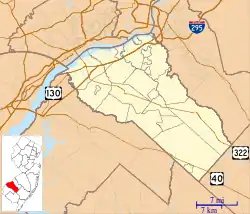
 Woolwich Township highlighted in Gloucester County. Inset map: Gloucester County highlighted in the State of New Jersey. | |
 Census Bureau map of Woolwich Township, New Jersey | |
 Woolwich Township Location in Gloucester County  Woolwich Township Location in New Jersey  Woolwich Township Location in the United States | |
| Coordinates: 39.743264°N 75.326111°W[1][2] | |
| Country | |
| State | |
| County | |
| Royal charter | March 7, 1767 |
| Incorporated | February 21, 1798 |
| Named for | Woolwich, England |
| Government | |
| • Type | Township |
| • Body | Township Committee |
| • Mayor | Vernon Marino (D, term as mayor ends December 31, 2020)[4][5][6] |
| • Administrator / Municipal clerk | Jane DiBella[7] |
| Area | |
| • Total | 21.39 sq mi (55.41 km2) |
| • Land | 21.07 sq mi (54.58 km2) |
| • Water | 0.32 sq mi (0.83 km2) 1.50% |
| Area rank | 132nd of 565 in state 5th of 24 in county[1] |
| Elevation | 66 ft (20 m) |
| Population | |
| • Total | 10,200 |
| • Estimate (2019)[12] | 12,960 |
| • Rank | 241st of 566 in state 9th of 24 in county[13] |
| • Density | 487.8/sq mi (188.3/km2) |
| • Density rank | 444th of 566 in state 20th of 24 in county[13] |
| Time zone | UTC−05:00 (Eastern (EST)) |
| • Summer (DST) | UTC−04:00 (Eastern (EDT)) |
| ZIP Code | 08085 - Swedesboro[14] |
| Area code(s) | 856 Exchanges: 241, 467[15] |
| FIPS code | 3401582840[1][16][17] |
| GNIS feature ID | 0882144[18] |
| Website | www |
Woolwich was formed by royal charter on March 7, 1767, from portions of Greenwich Township, and was incorporated as one of New Jersey's initial 104 townships by an act of the New Jersey Legislature on February 21, 1798. Portions of the township were taken to form Franklin Township (January 27, 1820), Spicer Township (March 13, 1844, now known as Harrison Township), West Woolwich Township (March 7, 1877, now known as Logan Township) and Swedesboro (April 9, 1902).[20][21] The township was named for Woolwich, England.[22]
Geography
According to the United States Census Bureau, the township had a total area of 21.39 square miles (55.41 km2), including 21.07 square miles (54.58 km2) of land and 0.32 square miles (0.83 km2) of water (1.50%).[1][2][23]
Swedesboro is an independent municipality entirely surrounded by the township, making it part one of 21 pairs of "doughnut towns" in the state, where one municipality entirely surrounds another.[24] The township borders the Gloucester County municipalities of East Greenwich Township, Harrison Township, Logan Township, Oldmans Township, Pilesgrove Township and South Harrison Township.[25][26]
Unincorporated communities, localities and place names located partially or completely within the township include Asbury, Dilkes Mills, Lippencott, Porches Mill, Robbins, Rulons and Scull.[27]
Demographics
| Historical population | |||
|---|---|---|---|
| Census | Pop. | %± | |
| 1800 | 2,768 | — | |
| 1810 | 3,063 | 10.7% | |
| 1820 | 3,113 | 1.6% | |
| 1830 | 3,033 | * | −2.6% |
| 1840 | 3,676 | 21.2% | |
| 1850 | 3,265 | * | −11.2% |
| 1860 | 3,478 | 6.5% | |
| 1870 | 3,760 | 8.1% | |
| 1880 | 1,974 | * | −47.5% |
| 1890 | 2,035 | 3.1% | |
| 1900 | 2,291 | 12.6% | |
| 1910 | 1,136 | * | −50.4% |
| 1920 | 973 | −14.3% | |
| 1930 | 1,196 | 22.9% | |
| 1940 | 1,193 | −0.3% | |
| 1950 | 1,343 | 12.6% | |
| 1960 | 1,235 | −8.0% | |
| 1970 | 1,147 | −7.1% | |
| 1980 | 1,129 | −1.6% | |
| 1990 | 1,459 | 29.2% | |
| 2000 | 3,032 | 107.8% | |
| 2010 | 10,200 | 236.4% | |
| 2019 (est.) | 12,960 | [12][28][29] | 27.1% |
| Population sources: 1800-2000[30] 1800-1920[31] 1840[32] 1850-1870[33] 1850[34] 1870[35] 1880-1890[36] 1890-1910[37] 1910-1930[38] 1930-1990[39] 2000[40][41] 2010[9][10][11] * = Lost territory in previous decade.[20] | |||
Census 2010
The 2010 United States Census counted 10,200 people, 3,141 households, and 2,730 families in the township. The population density was 487.8 per square mile (188.3/km2). There were 3,275 housing units at an average density of 156.6 per square mile (60.5/km2). The racial makeup was 81.14% (8,276) White, 9.97% (1,017) Black or African American, 0.13% (13) Native American, 6.02% (614) Asian, 0.00% (0) Pacific Islander, 0.78% (80) from other races, and 1.96% (200) from two or more races. Hispanic or Latino of any race were 3.58% (365) of the population.[9]
Of the 3,141 households, 54.4% had children under the age of 18; 78.0% were married couples living together; 6.0% had a female householder with no husband present and 13.1% were non-families. Of all households, 9.7% were made up of individuals and 2.9% had someone living alone who was 65 years of age or older. The average household size was 3.21 and the average family size was 3.46.[9]
33.5% of the population were under the age of 18, 4.9% from 18 to 24, 31.8% from 25 to 44, 23.4% from 45 to 64, and 6.4% who were 65 years of age or older. The median age was 35.7 years. For every 100 females, the population had 99.2 males. For every 100 females ages 18 and older there were 95.6 males.[9]
The Census Bureau's 2006-2010 American Community Survey showed that (in 2010 inflation-adjusted dollars) median household income was $109,360 (with a margin of error of +/- $6,043) and the median family income was $117,708 (+/- $6,397). Males had a median income of $82,370 (+/- $5,125) versus $52,083 (+/- $6,470) for females. The per capita income for the borough was $36,898 (+/- $2,081). About 3.6% of families and 3.6% of the population were below the poverty line, including 4.7% of those under age 18 and 8.7% of those age 65 or over.[42]
Census 2000
As of the 2000 United States Census[16] there were 3,032 people, 959 households, and 838 families residing in the township. The population density was 144.8 people per square mile (55.9/km2). There were 1,026 housing units at an average density of 49.0 per square mile (18.9/km2). The racial makeup of the township was 91.13% White, 4.55% African American, 1.12% Asian, 1.95% from other races, and 1.25% from two or more races. Hispanic or Latino people of any race were 3.89% of the population.[40][41]
There were 959 households, out of which 49.5% had children under the age of 18 living with them, 77.4% were married couples living together, 6.9% had a female householder with no husband present, and 12.6% were non-families. 8.6% of all households were made up of individuals, and 4.0% had someone living alone who was 65 years of age or older. The average household size was 3.13 and the average family size was 3.35.[40][41]
In the township the population was spread out, with 31.4% under the age of 18, 5.2% from 18 to 24, 38.0% from 25 to 44, 18.6% from 45 to 64, and 6.8% who were 65 years of age or older. The median age was 34 years. For every 100 females, there were 98.6 males. For every 100 females age 18 and over, there were 98.6 males.[40][41]
The median income for a household in the township was $83,790, and the median income for a family was $87,111. Males had a median income of $54,200 versus $38,571 for females. The per capita income for the township was $29,503. About 1.9% of families and 2.9% of the population were below the poverty line, including none of those under age 18 and 19.6% of those age 65 or over.[40][41]
Economy
Along U.S. Route 322 at New Jersey Turnpike exit 2, plans call for almost 1,500,000 square feet (140,000 m2) of retail and commercial space and an equal amount of office and flex park. Partnering with the state Office of Smart Growth, a major component of any development along Route 322 will include the use of transfer of development rights (TDR).[43]
Government
Local government
Woolwich Township is governed under the Township form of New Jersey municipal government, one of 141 municipalities (of the 565) statewide that use this form, the second-most commonly used form of government in the state.[44] The Township Committee is comprised of five members, who are elected directly by the voters at-large in partisan elections to serve three-year terms of office on a staggered basis, with either one or two seats coming up for election each year as part of the November general election in a three-year cycle.[3][45] At an annual reorganization meeting, the Township Committee selects one of its members to serve as Mayor and another as Deputy Mayor.[46]
As of 2020, members of the Woolwich Township Committee are Mayor Vernon R. Marino D, term on committee and as mayor ends December 31, 2020), Deputy Mayor Natalie Matthias (D, term on committee ends 2021; term as deputy mayor ends 2020), Craig A. Frederick (R, 2021), Michael Nocentino (D, 2022) and Gina Marie Santore (D, 2020).[4][47][48][49][50][51]
In 2018, the township had an average property tax bill of $10,727, the highest in the county, compared to an average bill of $8,767 statewide.[52]
Federal, state and county representation
Woolwich Township is located in the 2nd Congressional District[53] and is part of New Jersey's 3rd state legislative district.[10][54][55]
For the 116th United States Congress, New Jersey's Second Congressional District is represented by Jeff Van Drew (R, Dennis Township).[56] New Jersey is represented in the United States Senate by Democrats Cory Booker (Newark, term ends 2021)[57] and Bob Menendez (Paramus, term ends 2025).[58][59]
For the 2018–2019 session (Senate, General Assembly), the 3rd Legislative District of the New Jersey Legislature is represented in the State Senate by Stephen M. Sweeney (D, West Deptford Township) and in the General Assembly by John J. Burzichelli (D, Paulsboro) and Adam Taliaferro (D, Woolwich Township).[60][61]
Gloucester County is governed by a Board of Chosen Freeholders, whose seven members are elected at-large to three-year terms of office on a staggered basis in partisan elections, with two or three seats coming up for election each year. At a reorganization meeting held each January, the Board selects a Freeholder Director and a Deputy Freeholder Director from among its members. As of 2020, Gloucester County's Freeholders are Freeholder Director Robert M. Damminger (D, West Deptford Township; 2021),[62] Deputy Freeholder Director Frank J. DiMarco (D, Deptford Township; 2022),[63] Lyman J. Barnes (D, Logan Township; 2020),[64] Daniel Christy (D, Washington Township; 2022),[65] Jim Jefferson (D, Woodbury; 2020),[66] Jim Lavender (D, Woolwich Township; 2021),[67] and Heather Simmons (D, Glassboro; 2020).[68][69]
Constitutional officers elected countywide are: County Clerk James N. Hogan (D, Franklinville in Franklin Township; 5-year term ends 2022),[70][71][72] Sheriff Carmel Morina (D, Greenwich Township; 3-year term ends 2021)[73][74][75] and Surrogate Giuseppe "Joe" Chila (D, Woolwich Township; 5-year term ends 2022).[76][77][78][72][79][75]
Politics
As of March 23, 2011, there were a total of 6,032 registered voters in Woolwich, of which 1,675 (27.8%) were registered as Democrats, 1,287 (21.3%) were registered as Republicans and 3,067 (50.8%) were registered as Unaffiliated. There were 3 voters registered to other parties.[80]
In the 2012 presidential election, Republican Mitt Romney received 52.0% of the vote (2,536 cast), ahead of Democrat Barack Obama with 46.9% (2,289 votes), and other candidates with 1.1% (53 votes), among the 4,897 ballots cast by the township's 6,682 registered voters (19 ballots were spoiled), for a turnout of 73.3%.[81][82] In the 2008 presidential election, Democrat Barack Obama received 50.9% of the vote (2,316 cast), ahead of Republican John McCain with 47.6% (2,163 votes) and other candidates with 1.0% (44 votes), among the 4,547 ballots cast by the township's 5,858 registered voters, for a turnout of 77.6%.[83] In the 2004 presidential election, Republican George W. Bush received 57.6% of the vote (1,767 ballots cast), outpolling Democrat John Kerry with 41.5% (1,273 votes) and other candidates with 0.5% (20 votes), among the 3,070 ballots cast by the township's 3,736 registered voters, for a turnout percentage of 82.2.[84]
In the 2013 gubernatorial election, Republican Chris Christie received 70.8% of the vote (1,989 cast), ahead of Democrat Barbara Buono with 28.1% (788 votes), and other candidates with 1.1% (31 votes), among the 2,848 ballots cast by the township's 6,845 registered voters (40 ballots were spoiled), for a turnout of 41.6%.[85][86] In the 2009 gubernatorial election, Republican Chris Christie received 55.1% of the vote (1,594 ballots cast), ahead of Democrat Jon Corzine with 36.5% (1,055 votes), Independent Chris Daggett with 6.7% (195 votes) and other candidates with 0.4% (13 votes), among the 2,892 ballots cast by the township's 5,800 registered voters, yielding a 49.9% turnout.[87]
Education
Public school students in kindergarten through sixth grade attend the Swedesboro-Woolwich School District, a consolidated school district that serves students from both Swedesboro and Woolwich Township. As of the 2017–18 school year, the district, comprised of four schools, had an enrollment of 1,615 students and 141.7 classroom teachers (on an FTE basis), for a student–teacher ratio of 11.7:1.[88] Schools in the district (with 2017-18 enrollment data from the National Center for Education Statistics[89]) are Margaret C. Clifford School[90] (243 students; in grades PreK and K), Charles C. Stratton School[91] (270 students; grades 1–2), Charles G. Harker School[92] (714 students; grades 3–5) and Walter Hill School[93] (270 students; grade 6).[94][95]
Public school students in seventh through twelfth grades are educated by the Kingsway Regional School District, which also serves students from East Greenwich Township, South Harrison Township and Swedesboro, with the addition of students from Logan Township who attend the district's high school as part of a sending/receiving relationship in which tuition is paid on a per-pupil basis by the Logan Township School District. Woolwich Township accounts for one third of district enrollment.[96][97] As of the 2017–18 school year, the district, comprising two schools, had an enrollment of 2,764 students and 185.8 classroom teachers (on an FTE basis), for a student–teacher ratio of 14.9:1.[98] The schools in the district (with 2017-18 enrollment data from the National Center for Education Statistics[99]) are Kingsway Regional Middle School[100] with 963 students in grades 7-8 and Kingsway Regional High School[101] with 1,750 students in grades 9-12.[102] Under a 2011 proposal, Kingsway would merge with its constituent member's K-6 districts to become a full K-12 district, with various options for including Logan Township as part of the consolidated district.[103]
Students from across the county are eligible to apply to attend Gloucester County Institute of Technology, a four-year high school in Deptford Township that provides technical and vocational education. As a public school, students do not pay tuition to attend the school.[104]
Transportation
_at_Exit_2_(U.S._Route_322%252C_Swedesboro%252C_Glassboro)_in_Woolwich_Township%252C_Gloucester_County%252C_New_Jersey.jpg.webp)
Roads and highways
As of May 2010, the township had a total of 93.31 miles (150.17 km) of roadways, of which 51.93 miles (83.57 km) were maintained by the municipality, 32.05 miles (51.58 km) by Gloucester County and 3.62 miles (5.83 km) by the New Jersey Department of Transportation and 5.71 miles (9.19 km) by the New Jersey Turnpike Authority.[105]
U.S. Route 322 passes through the center of the municipality[106] while the New Jersey Turnpike passes through the southeastern part of the township for about 5.75 miles (9.25 km)[107] and connects to Route 322 at Interchange 2.[108]
Major county roads that pass through include CR 538 and CR 551.
Interstate 295 is accessible outside the municipality in neighboring Logan, Oldmans and Greenwich Townships.
Public transportation
NJ Transit bus service between Salem and Philadelphia is available on the 401 route.[109][110]
Wineries
Community
In its April 2006 issue listing the Top Places to Live in New Jersey, New Jersey Monthly magazine rated Woolwich as the worst place to live in all of New Jersey, placing 566th out of 566 municipalities.[111] As of February 2008, the municipality is ranked as 547 out of 566 municipalities. Meanwhile, its population has grown a staggering 185% from 2000 to 2006.[112]
The community was labeled the "Number 1 Area Boomtown" in 2005.[113]
Historic sites
The Gov. Charles C. Stratton House was built in 1791 and added to the National Register of Historic Places on January 29, 1973. The house was the home of New Jersey Governor Charles C. Stratton.[114]
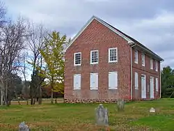
Moravian Church is a historic church building built in 1786 and added to the National Register of Historic Places in 1973.[115]
Mount Zion African Methodist Episcopal Church and Mount Zion Cemetery is a historic church built in 1834 and added to the National Register of Historic Places in 2001. It played an important role in the Underground Railroad in South Jersey.[116]
Notable people
People who were born in, residents of, or otherwise closely associated with Woolwich Township include:
- Jason Babin (born 1980), defensive end for the Philadelphia Eagles[117]
- Marlon Byrd (born 1977), baseball outfielder for the Philadelphia Phillies[118]
- Hank Fraley (born 1977), offensive lineman for the Cleveland Browns[119]
- Ellis Hobbs (born 1983), former cornerback for the Philadelphia Eagles[120]
- Michael McCary (born 1971), former bass singer of the R&B group Boyz II Men[121]
- Jason Peters (born 1982), offensive tackle for the Philadelphia Eagles[122]
- Jimmy Rollins (born 1978), Major League Baseball shortstop especially known for his time with the Philadelphia Phillies[123]
- Adam Taliaferro (born 1982), paralyzed former college football player who has served in the New Jersey General Assembly[124]
References
- 2019 Census Gazetteer Files: New Jersey Places, United States Census Bureau. Accessed July 1, 2020.
- US Gazetteer files: 2010, 2000, and 1990, United States Census Bureau. Accessed September 4, 2014.
- 2012 New Jersey Legislative District Data Book, Rutgers University Edward J. Bloustein School of Planning and Public Policy, March 2013, p. 19.
- Township Committee, Woolwich Township. Accessed March 9, 2020.
- Township Committee Meeting Minutes for January 2, 2019, Woolwich Township. Accessed July 21, 2019. "The Clerk called for nominations for Woolwich Township Mayor for the year 2019. Committeewoman Santore moved to nominate Vernon Marino. Committeeman Battisti seconded. There were no further nominations.
- 2020 New Jersey Mayors Directory, New Jersey Department of Community Affairs. Accessed February 1, 2020.
- Administrative Offices, Woolwich Township. Accessed November 10, 2019.
- U.S. Geological Survey Geographic Names Information System: Township of Woolwich, Geographic Names Information System. Accessed March 14, 2013.
- DP-1 - Profile of General Population and Housing Characteristics: 2010 for Woolwich township, Gloucester County, New Jersey Archived February 12, 2020, at Archive.today, United States Census Bureau. Accessed November 10, 2012.
- Municipalities Sorted by 2011-2020 Legislative District, New Jersey Department of State. Accessed February 1, 2020.
- Profile of General Demographic Characteristics: 2010 for Woolwich township, New Jersey Department of Labor and Workforce Development. Accessed November 10, 2012.
- QuickFacts for Woolwich township, Gloucester County, New Jersey; Gloucester County, New Jersey; New Jersey from Population estimates, July 1, 2019, (V2019), United States Census Bureau. Accessed May 21, 2020.
- GCT-PH1 Population, Housing Units, Area, and Density: 2010 - State -- County Subdivision from the 2010 Census Summary File 1 for New Jersey Archived February 12, 2020, at Archive.today, United States Census Bureau. Accessed November 10, 2012.
- Look Up a ZIP Code for Woolwich, NJ, United States Postal Service. Accessed November 10, 2012.
- Area Code Lookup - NPA NXX for Swedesboro, NJ, Area-Codes.com. Accessed October 6, 2014.
- U.S. Census website , United States Census Bureau. Accessed September 4, 2014.
- Geographic codes for New Jersey, Missouri Census Data Center. Accessed September 1, 2019.
- US Board on Geographic Names, United States Geological Survey. Accessed September 4, 2014.
- Table 7. Population for the Counties and Municipalities in New Jersey: 1990, 2000 and 2010, New Jersey Department of Labor and Workforce Development, February 2011. Accessed November 10, 2012.
- Snyder, John P. The Story of New Jersey's Civil Boundaries: 1606-1968, Bureau of Geology and Topography; Trenton, New Jersey; 1969. p. 142. Accessed October 25, 2012.
- Honeyman, Abraham Van Doren. Index-analysis of the Statutes of New Jersey, 1896-1909: Together with References to All Acts, and Parts of Acts, in the 'General Statutes' and Pamphlet Laws Expressly Repealed: and the Statutory Crimes of New Jersey During the Same Period, p. 315. New Jersey Law Journal Publishing Company, 1910. Accessed November 8, 2015.
- Hutchinson, Viola L. The Origin of New Jersey Place Names, New Jersey Public Library Commission, May 1945. Accessed November 8, 2015.
- Open Space and Recreation Plan, Woolwich Township. Accessed January 26, 2020. "Woolwich Township has an area of 21.2 square miles with 0.32 square miles (1.5%) of the Township’s area being comprised of water."
- DeMarco, Megan. "Voters to decide whether to merge two Princetons into one", The Star-Ledger, November 3, 2011. Accessed January 8, 2017. "There are 22 sets of 'doughnut towns' in New Jersey, those where one town wraps around the other town". Note that following voter approval of the Princeton, New Jersey merger, 21 pairs of "doughnut towns" remain.
- Municipalities within Gloucester County, NJ, Delaware Valley Regional Planning Commission. Accessed November 7, 2019.
- New Jersey Municipal Boundaries, New Jersey Department of Transportation. Accessed November 7, 2019.
- Locality Search, State of New Jersey. Accessed April 26, 2015.
- Annual Estimates of the Resident Population for Minor Civil Divisions in New Jersey: April 1, 2010 to July 1, 2019, United States Census Bureau. Accessed May 21, 2020.
- Census Estimates for New Jersey April 1, 2010 to July 1, 2019, United States Census Bureau. Accessed May 21, 2020.
- Barnett, Bob. "Population Data for Gloucester County Municipalities, 1800 - 2000, WestJersey.org, January 6, 2011. Accessed November 10, 2012.
- Compendium of censuses 1726-1905: together with the tabulated returns of 1905, New Jersey Department of State, 1906. Accessed July 24, 2013.
- Bowen, Francis. American Almanac and Repository of Useful Knowledge for the Year 1843, p. 232, David H. Williams, 1842. Accessed July 24, 2013.
- Raum, John O. The History of New Jersey: From Its Earliest Settlement to the Present Time, Volume 1, p. 258, J. E. Potter and company, 1877. Accessed July 24, 2013. "Woolwich township contained in 1850, 3,265 inhabitants; in 1860, 3,478; and in 1870 3,760."
- Debow, James Dunwoody Brownson. The Seventh Census of the United States: 1850, p. 138. R. Armstrong, 1853. Accessed July 24, 2013.
- Staff. A compendium of the ninth census, 1870, p. 259. United States Census Bureau, 1872. Accessed July 24, 2013.
- Porter, Robert Percival. Preliminary Results as Contained in the Eleventh Census Bulletins: Volume III - 51 to 75, p. 98. United States Census Bureau, 1890. Accessed July 24, 2013. Results are listed as being coextensive with Swedesboro town.
- Thirteenth Census of the United States, 1910: Population by Counties and Minor Civil Divisions, 1910, 1900, 1890, United States Census Bureau, p. 336. Accessed November 10, 2012.
- Fifteenth Census of the United States : 1930 - Population Volume I, United States Census Bureau, p. 716. Accessed November 10, 2012.
- Table 6. New Jersey Resident Population by Municipality: 1930 - 1990, New Jersey Department of Labor and Workforce Development. Accessed June 28, 2015.
- Census 2000 Profiles of Demographic / Social / Economic / Housing Characteristics for Woolwich township, Gloucester County, New Jersey Archived July 11, 2007, at the Wayback Machine, United States Census Bureau. Accessed November 10, 2012.
- DP-1: Profile of General Demographic Characteristics: 2000 - Census 2000 Summary File 1 (SF 1) 100-Percent Data for Woolwich township, Gloucester County, New Jersey Archived February 12, 2020, at Archive.today, United States Census Bureau. Accessed November 10, 2012.
- DP03: Selected Economic Characteristics from the 2006-2010 American Community Survey 5-Year Estimates for Woolwich township, Gloucester County, New Jersey Archived February 12, 2020, at Archive.today, United States Census Bureau. Accessed November 10, 2012.
- About Woolwich, Choose Woolwich. Accessed April 26, 2015.
- Inventory of Municipal Forms of Government in New Jersey, Rutgers University Center for Government Studies, July 1, 2011. Accessed November 18, 2019.
- "Forms of Municipal Government in New Jersey", p. 7. Rutgers University Center for Government Studies. Accessed June 3, 2015.
- Government, Woolwich Township. Accessed July 6, 2016.
- 2019 Municipal Data Sheet, Woolwich Township. Accessed November 10, 2019.
- Gloucester County 2020 Official Directory, Gloucester County, New Jersey. Accessed March 9, 2020.
- General Election November 5, 2019 Summary Report Unofficial Results, Gloucester County, New Jersey Clerk, November 12, 2019. Accessed January 1, 2020.
- General Election November 6, 2018 Summary Report Unofficial Results, Gloucester County, New Jersey Clerk, November 12, 2018. Accessed January 1, 2019.
- General Election November 7, 2017 Summary Report Unofficial Results, Gloucester County, New Jersey Clerk, November 14, 2017. Accessed January 1, 2018.
- Marcus, Samantha. "These are the towns with the highest property taxes in each of N.J.’s 21 counties", NJ Advance Media for NJ.com, April 22, 2019. Accessed November 5, 2019. "The average property tax bill in New Jersey was $8,767 last year. But there can be big swings from town to town and county to county.... The average property tax bill in Woolwich Township was $10,727 in 2018, the highest in Gloucester County."
- Plan Components Report, New Jersey Redistricting Commission, December 23, 2011. Accessed February 1, 2020.
- 2019 New Jersey Citizen's Guide to Government, New Jersey League of Women Voters. Accessed October 30, 2019.
- Districts by Number for 2011-2020, New Jersey Legislature. Accessed January 6, 2013.
- Directory of Representatives: New Jersey, United States House of Representatives. Accessed January 3, 2019.
- About Cory Booker, United States Senate. Accessed January 26, 2015. "He now owns a home and lives in Newark's Central Ward community."
- Biography of Bob Menendez, United States Senate, January 26, 2015. "He currently lives in Paramus and has two children, Alicia and Robert."
- Senators of the 116th Congress from New Jersey. United States Senate. Accessed April 17, 2019. "Booker, Cory A. - (D - NJ) Class II; Menendez, Robert - (D - NJ) Class I"
- Legislative Roster 2018-2019 Session, New Jersey Legislature. Accessed January 21, 2018.
- District 3 Legislators, New Jersey Legislature. Accessed January 22, 2018.
- Robert M. Damminger, Gloucester County, New Jersey. Accessed February 11, 2020.
- Frank J. DiMarco, Gloucester County, New Jersey. Accessed February 11, 2020.
- Lyman Barnes, Gloucester County, New Jersey. Accessed February 11, 2020.
- Daniel Christy, Gloucester County, New Jersey. Accessed February 11, 2020.
- Jim Jefferson, Gloucester County, New Jersey. Accessed February 11, 2020.
- Jim Lavender, Gloucester County, New Jersey. Accessed February 11, 2020.
- Heather Simmons, Gloucester County, New Jersey. Accessed February 11, 2020.
- Board of Freeholders, Gloucester County, New Jersey. Accessed February 11, 2020.
- James N. Hogan, Gloucester County. Accessed February 11, 2020.
- Members List: Clerks, Constitutional Officers Association of New Jersey. Accessed February 11, 2020.
- 2017 Gloucester County Election Results, Office of the Gloucester County Clerk. Accessed February 11, 2020.
- Sheriff Carmel M. Morina, Gloucester County. Accessed February 11, 2020.
- Members List: Sheriffs, Constitutional Officers Association of New Jersey. Accessed February 11, 2020.
- 2018 Gloucester County Election Results, Office of the Gloucester County Clerk. Accessed February 11, 2020.
- Surrogate Giuseppe Chila, Gloucester County. Accessed February 11, 2020.
- Members List: Surrogates, Constitutional Officers Association of New Jersey. Accessed February 11, 2020.
- Row Officers, Gloucester County, New Jersey. Accessed February 11, 2020.
- Helene Reed Dies, New Jersey Globe, April 28, 2018. Accessed February 11, 2020.
- Voter Registration Summary - Gloucester, New Jersey Department of State Division of Elections, March 23, 2011. Accessed November 10, 2012.
- "Presidential General Election Results - November 6, 2012 - Gloucester County" (PDF). New Jersey Department of Elections. March 15, 2013. Retrieved December 24, 2014.
- "Number of Registered Voters and Ballots Cast - November 6, 2012 - General Election Results - Gloucester County" (PDF). New Jersey Department of Elections. March 15, 2013. Retrieved December 24, 2014.
- 2008 Presidential General Election Results: Gloucester County, New Jersey Department of State Division of Elections, December 23, 2008. Accessed November 10, 2012.
- 2004 Presidential Election: Gloucester County, New Jersey Department of State Division of Elections, December 13, 2004. Accessed November 10, 2012.
- "Governor - Gloucester County" (PDF). New Jersey Department of Elections. January 29, 2014. Retrieved December 24, 2014.
- "Number of Registered Voters and Ballots Cast - November 5, 2013 - General Election Results - Gloucester County" (PDF). New Jersey Department of Elections. January 29, 2014. Retrieved December 24, 2014.
- 2009 Governor: Gloucester County Archived October 17, 2012, at the Wayback Machine, New Jersey Department of State Division of Elections, December 31, 2009. Accessed November 10, 2012.
- District information for Swedesboro-Woolwich School District, National Center for Education Statistics. Accessed November 10, 2019.
- School Data for the Swedesboro-Woolwich School District, National Center for Education Statistics. Accessed November 10, 2019.
- Margaret C. Clifford School, Swedesboro-Woolwich School District. Accessed November 10, 2019.
- Charles C. Stratton School, Swedesboro-Woolwich School District. Accessed November 10, 2019.
- Charles G. Harker School, Swedesboro-Woolwich School District. Accessed November 10, 2019.
- Walter Hill School, Swedesboro-Woolwich School District. Accessed November 10, 2019.
- School Locations, Swedesboro-Woolwich School District. Accessed November 10, 2019.
- New Jersey School Directory for the Swedesboro-Woolwich School District, New Jersey Department of Education. Accessed December 29, 2016.
- Kingsway Regional School District 2015 Report Card Narrative, New Jersey Department of Education. Accessed March 9, 2020. "Kingsway is situated in a predominately rural/suburban area, with more than 20,000 people residing within its 52 square mile border. The District includes the Borough of Swedesboro and the Townships of South Harrison, East Greenwich, and Woolwich. Though not part of the District, students from Logan Township attend Kingsway High School through a send/receive relationship as paid tuition students."
- Student Enrollment, Kingsway Regional School District. Accessed March 9, 2020. "Kingsway Regional is comprised of the Borough of Swedesboro and the Townships of South Harrison, East Greenwich and Woolwich. Though not part of the District, students from Logan Township attend Kingsway Regional High School through a send/receive relationship as paid tuition students.... Percent of students coming from each resident district is as follows: East Greenwich Twp. – 32%, Woolwich Twp. – 33%, South Harrison Twp. – 13%, Swedesboro – 10%, Logan Twp. (High School Only) – 11%"
- District information for Kingsway Regional School District, National Center for Education Statistics. Accessed November 7, 2019.
- School Data for the Kingsway Regional School District, National Center for Education Statistics. Accessed November 10, 2019.
- Kingsway Regional Middle School, Kingsway Regional School District. Accessed November 10, 2019.
- Kingsway Regional High School, Kingsway Regional School District. Accessed November 10, 2019.
- New Jersey School Directory for the Kingsway Regional School District, New Jersey Department of Education. Accessed December 22, 2016.
- Forand, Rebecca. "Kingsway districts may see change", Gloucester County Times, April 7, 2011. Accessed December 9, 2014. "A study is being planned to evaluate the fiscal feasibility of the regionalization of the school districts associated with the Kingsway Regional district, and the impact of continuing or severing the current relationship the district has with Logan Township. Woolwich township, Swedesboro, East Greenwich Township and South Harrison Township all currently feed their elementary students to the Kingsway Regional district for middle and high school, with Logan Township sending students to the high school on a tuition basis. The study will address the fiscal feasibility of regionalizing Kingsway, East Greenwich, South Harrison and Swedesboro-Woolwich."
- Admissions, Gloucester County Institute of Technology. Accessed November 7, 2019. "There is no charge to attend. GCIT is a public school.... GCIT is the vocational-technical school for Gloucester County residents. You must live in Gloucester County to apply and attend."
- Gloucester County Mileage by Municipality and Jurisdiction, New Jersey Department of Transportation, May 2010. Accessed July 18, 2014.
- U.S. Route 322 Straight Line Diagram, New Jersey Department of Transportation, updated May 2017. Accessed November 10, 2019.
- New Jersey Turnpike Straight Line Diagram, New Jersey Department of Transportation, updated August 2014. Accessed November 10, 2019.
- Travel Resources: Interchanges, Service Areas & Commuter Lots, New Jersey Turnpike Authority. Accessed October 6, 2014.
- Gloucester County Bus / Rail Connections, NJ Transit, backed up by the Internet Archive as of July 26, 2010. Accessed November 8, 2012.
- Gloucester County's Transit Guide, Gloucester County, New Jersey. Accessed November 7, 2019.
- Top Places to Live in New Jersey: Woolwich Township, New Jersey Monthly, April 2006. Accessed August 28, 2007.
- Best Places to Live in New Jersey: Woolwich Township
- Fifield, Adam. "Area's No. 1 boomtown is asking: What now? (Woolwich Township, NJ)", The Philadelphia Inquirer, July 8, 2005. Accessed April 23, 2008.
- New Jersey and National Registers of Historic Places: Gloucester County, New Jersey Department of Environmental Protection Historic Preservation Office, October 27, 2015. Accessed November 8, 2015.
- Moravian Church, Oliphant's Mill, Gloucester County, New Jersey, Library of Congress. Accessed November 8, 2015.
- Roncace, Kelly. "Three major Underground Railroad routes were in South Jersey", NJ.com, February 6, 2011. Accessed November 8, 2015. "One of the most important stops for fleeing slaves who traveled through Gloucester County was the Mount Zion African Methodist Episcopal Church in what was then known as Small Gloucester. The church still stands and the congregation still worships every Sunday in what is now known as Woolwich Township.The church, founded in 1799 and built in 1834, actively provided protection, supplies and shelter for runaway slaves, according to congregation member and historian Karyn Collier Fisher."
- "Sales Information for 164 CEDAR CT - NJParcels.com - New Jersey Property Data". Retrieved December 24, 2018. "Buyer: BABIN, JASON & SARA, 164 CEDAR COURT, WOOLWICH TWP, NJ"
- "Sales Information for 164 CEDAR CT - NJParcels.com - New Jersey Property Data". Retrieved December 24, 2018. "Buyer: BYRD, MARLON J & ANDREA, 164 CEDAR COURT, WOOLWICH TWP, NJ"
- 10 Questions with Hank Fraley, Robert Morris University, Fall 2008. Accessed January 8, 2012. "Fraley and his wife, Danielle, reside in Woolwich Township, N.J., and have three sons together: Mason, Travis and Beau."
- "Gloucester County real estate transactions". Retrieved December 24, 2018. "WOOLWICH TWP. 548 Leone Road, Ellis Hue Hobbs III and Monique Hobbs to Kenneth A. and Mary A. Morris, $440,000"
- "Sales Information for 120 FOX CHASE CT - NJParcels.com - New Jersey Property Data". Retrieved December 24, 2018. "Buyer: MC CARY, MICHAEL S & VENUS, 120 FOXCHASE COURT, WOOLWICH TWP, NJ"
- "NFL Cribs: Where Do the Highest-Flying Philadelphia Eagles Choose to Nest?". Retrieved May 22, 2018.
- Shryock, Bob. "Local took his shot at fame", Gloucester County Times, December 13, 2007, backed up by the Internet Archive as of December 15, 2007. Accessed May 31, 2018. "A recent column about famous Gloucester County residents, sparked by Woolwich Township transplant Jimmy Rollins being named National League MVP, encouraged readers to submit their own nominations to the unofficial list of luminaries."
- Romalino, Carly Q. "Freeholder-elect Taliaferro admits to pre-swearing-in jitters", Gloucester County Times, January 3, 2012. Accessed January 8, 2012. "'There are some nerves, but I am confident,' said Taliaferro, of Woolwich Township. 'When I first sit down, for me, it's finally time to do work. To have the opportunity to get started is really going to be exciting to me.'"
External links
| Wikimedia Commons has media related to Woolwich Township, New Jersey. |
- Woolwich Township website
- Swedesboro-Woolwich School District
- Swedesboro-Woolwich School District's 2015–16 School Report Card from the New Jersey Department of Education
- School Data for the Swedesboro-Woolwich School District, National Center for Education Statistics
- Kingsway Regional High School
- Woolwich Business Development Advisory Committee
Municipalities and communities of Gloucester County, New Jersey, United States | ||
|---|---|---|
| City | 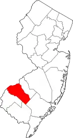 Map of New Jersey highlighting Gloucester County | |
| Boroughs | ||
| Townships | ||
| CDPs | ||
| Other unincorporated communities |
| |
| ||
Places adjacent to Woolwich Township, New Jersey | |
|---|---|