Mantua Township, New Jersey
Mantua Township is a township in Gloucester County, New Jersey, United States. As of the 2010 United States Census, the township's population was 15,217,[9][10][11] reflecting an increase of 1,000 (+7.0%) from the 14,217 counted in the 2000 Census, which had in turn increased by 4,143 (+41.1%) from the 10,074 counted in the 1990 Census.[20]
Mantua Township, New Jersey | |
|---|---|
| Township of Mantua | |
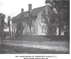 Thomas Carpenter House | |
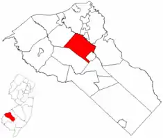 Mantua Township highlighted in Gloucester County. Inset map: Gloucester County highlighted in the State of New Jersey. | |
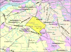 Census Bureau map of Mantua Township, New Jersey | |
 Mantua Township Location in Gloucester County 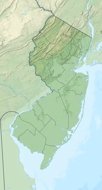 Mantua Township Location in New Jersey  Mantua Township Location in the United States | |
| Coordinates: 39.762013°N 75.173092°W[1][2] | |
| Country | |
| State | |
| County | |
| Incorporated | February 23, 1853 |
| Named for | Mantua, Italy or Lenape sub-tribe |
| Government | |
| • Type | Township |
| • Body | Township Committee |
| • Mayor | Peter Scirrotto (D, term ends December 31, 2020)[4][5] |
| • Administrator | Jennica Bileci[6] |
| • Municipal clerk | Jennica Bileci[7] |
| Area | |
| • Total | 16.09 sq mi (41.67 km2) |
| • Land | 16.01 sq mi (41.45 km2) |
| • Water | 0.09 sq mi (0.22 km2) 0.53% |
| Area rank | 169th of 565 in state 10th of 24 in county[1] |
| Elevation | 105 ft (32 m) |
| Population | |
| • Total | 15,217 |
| • Estimate (2019)[12] | 14,840 |
| • Rank | 166th of 566 in state 7th of 24 in county[13] |
| • Density | 960.1/sq mi (370.7/km2) |
| • Density rank | 389th of 566 in state 14th of 24 in county[13] |
| Time zone | UTC−05:00 (Eastern (EST)) |
| • Summer (DST) | UTC−04:00 (Eastern (EDT)) |
| ZIP Code | |
| Area code(s) | 856 exchanges: 223, 415, 464, 468[16] |
| FIPS code | 3401543440[1][17][18] |
| GNIS feature ID | 0882147[1][19] |
| Website | www |
Mantua Township was formed as a township by an act of the New Jersey Legislature on February 23, 1853, from portions of Greenwich Township. Portions of the township were taken to form East Greenwich Township (February 10, 1881) and Pitman (May 24, 1905).[21] The township is named after Mantua, in Italy[22] or for a Mantua sub-tribe of the Lenape Native Americans.[23][24]
Geography
According to the United States Census Bureau, the township had a total area of 16.09 square miles (41.67 km2), including 16.01 square miles (41.45 km2) of land and 0.09 square miles (0.22 km2) of water (0.53%).[1][2]
Richwood is an unincorporated community and census-designated place (CDP) located within portions of both Harrison Township and Mantua Township. The CDP had a 2010 population of 3,459, of which 3,400 were in Harrison Township and 59 in Mantua Township.[25][26] Other unincorporated communities, localities and place names located partially or completely within the township include Barnsboro, Boodys Mills, Centre City, Eastlack Corner, Jessups, Manunkachunk, Sewell and West Landing.[27]
The township borders Deptford Township, East Greenwich Township, Glassboro, Harrison Township, Pitman, Washington Township, Wenonah and West Deptford Township.[28][29]
Demographics
| Historical population | |||
|---|---|---|---|
| Census | Pop. | %± | |
| 1860 | 1,742 | — | |
| 1870 | 1,897 | 8.9% | |
| 1880 | 1,718 | −9.4% | |
| 1890 | 1,791 | * | 4.2% |
| 1900 | 2,101 | 17.3% | |
| 1910 | 1,529 | * | −27.2% |
| 1920 | 2,002 | 30.9% | |
| 1930 | 2,677 | 33.7% | |
| 1940 | 2,433 | −9.1% | |
| 1950 | 3,548 | 45.8% | |
| 1960 | 7,991 | 125.2% | |
| 1970 | 9,643 | 20.7% | |
| 1980 | 9,193 | −4.7% | |
| 1990 | 10,074 | 9.6% | |
| 2000 | 14,217 | 41.1% | |
| 2010 | 15,217 | 7.0% | |
| 2019 (est.) | 14,840 | [12][30][31] | −2.5% |
| Population sources: 1860-2000[32] 1860-1920[33] 1860-1870[34] 1870[35] 1880-1890[36] 1890-1910[37] 1910-1930[38] 1930-1990[39] 2000[40][41] 2010[9][10][11] * Lost territory in previous decade | |||
Census 2010
The 2010 United States Census counted 15,217 people, 5,719 households, and 4,169 families in the township. The population density was 960.1 per square mile (370.7/km2). There were 5,980 housing units at an average density of 377.3 per square mile (145.7/km2). The racial makeup was 94.24% (14,340) White, 2.50% (380) Black or African American, 0.20% (31) Native American, 1.10% (168) Asian, 0.01% (1) Pacific Islander, 0.66% (100) from other races, and 1.29% (197) from two or more races. Hispanic or Latino of any race were 2.95% (449) of the population.[9]
Of the 5,719 households, 33.4% had children under the age of 18; 57.3% were married couples living together; 11.1% had a female householder with no husband present and 27.1% were non-families. Of all households, 22.2% were made up of individuals and 8.8% had someone living alone who was 65 years of age or older. The average household size was 2.66 and the average family size was 3.13.[9]
24.1% of the population were under the age of 18, 8.1% from 18 to 24, 25.4% from 25 to 44, 29.5% from 45 to 64, and 12.8% who were 65 years of age or older. The median age was 40.3 years. For every 100 females, the population had 92.9 males. For every 100 females ages 18 and older there were 88.8 males.[9]
The Census Bureau's 2006-2010 American Community Survey showed that (in 2010 inflation-adjusted dollars) median household income was $80,743 (with a margin of error of +/- $4,473) and the median family income was $88,586 (+/- $5,058). Males had a median income of $66,993 (+/- $4,279) versus $49,500 (+/- $7,015) for females. The per capita income for the borough was $35,073 (+/- $2,942). About 2.7% of families and 4.5% of the population were below the poverty line, including 8.1% of those under age 18 and 3.6% of those age 65 or over.[42]
Census 2000
As of the 2000 United States Census[17] there were 14,217 people, 5,265 households, and 3,948 families residing in the township. The population density was 894.3 people per square mile (345.2/km2). There were 5,411 housing units at an average density of 340.4 per square mile (131.4/km2). The racial makeup of the township was 95.81% White, 2.07% African American, 0.20% Native American, 0.86% Asian, 0.28% from other races, and 0.78% from two or more races. Hispanic or Latino of any race were 1.26% of the population.[40][41]
There were 5,265 households, out of which 36.9% had children under the age of 18 living with them, 62.1% were married couples living together, 9.0% had a female householder with no husband present, and 25.0% were non-families. 21.1% of all households were made up of individuals, and 7.3% had someone living alone who was 65 years of age or older. The average household size was 2.69 and the average family size was 3.14.[40]
In the township the population was spread out, with 26.7% under the age of 18, 6.3% from 18 to 24, 33.6% from 25 to 44, 22.3% from 45 to 64, and 11.1% who were 65 years of age or older. The median age was 36 years. For every 100 females, there were 96.0 males. For every 100 females age 18 and over, there were 92.5 males.[40]
The median income for a household in the township was $58,256, and the median income for a family was $63,391. Males had a median income of $46,984 versus $32,495 for females. The per capita income for the township was $24,147. About 2.8% of families and 3.6% of the population were below the poverty line, including 4.3% of those under age 18 and 2.1% of those age 65 or over.[40]
Parks and recreation
Tall Pines State Preserve is a 111-acre (45 ha) nature preserve that opened in November 2015 as Gloucester County's first state park and is located along the border of Deptford Township and Mantua Township. Originally a forest that was turned into an asparagus field and then a golf course, the land was preserved through the efforts of the South Jersey Land and Water Trust, the Friends of Tall Pines, Gloucester County Nature Club, and the New Jersey Green Acres Program.[43]
Government
Local government
Mantua Township is governed under the Township form of New Jersey municipal government, one of 141 municipalities (of the 565) statewide that use this form, the second-most commonly used form of government in the state.[44] The Township Committee is comprised of five members, who are elected directly by the voters at-large in partisan elections to serve three-year terms of office on a staggered basis, with either one or two seats coming up for election each year as part of the November general election in a three-year cycle.[3][45] At an annual reorganization meeting, the Township Committee selects one of its members to serve as Mayor and another as Deputy Mayor.[4]
As of 2020, members of the Mantua Township Committee are Mayor Pete Scirrotto (D, term on committee ends December 31, 2022; term as mayor ends 2020), Deputy Mayor Robert T. Zimmerman (D, term on committee ends 2021; term as deputy mayor ends 2020), Shawn K. Layton (D, 2021), John Legge (D, 2020) and Eileen Lukens (D, 2022).[4][46][47][48][49][50]
Federal, state and county representation
Mantua Township is located in the 2nd Congressional District[51] and is part of New Jersey's 5th state legislative district.[10][52][53] Prior to the 2011 reapportionment following the 2010 Census, Mantua Township had been in the 3rd state legislative district.[54] Prior to the 2010 Census, Mantua Township had been split between the 1st Congressional District and the 2nd Congressional District, a change made by the New Jersey Redistricting Commission that took effect in January 2013, based on the results of the November 2012 general elections.[54]
For the 116th United States Congress, New Jersey's Second Congressional District is represented by Jeff Van Drew (R, Dennis Township).[55] New Jersey is represented in the United States Senate by Democrats Cory Booker (Newark, term ends 2021)[56] and Bob Menendez (Paramus, term ends 2025).[57][58]
For the 2018–2019 session (Senate, General Assembly), the 5th Legislative District of the New Jersey Legislature is represented in the State Senate by Nilsa Cruz-Perez (D, Barrington) and in the General Assembly by Patricia Egan Jones (D, Barrington) and William Spearman (D, Camden).[59][60] Spearman took office in June 2018 following the resignation of Arthur Barclay.[61]
Gloucester County is governed by a Board of Chosen Freeholders, whose seven members are elected at-large to three-year terms of office on a staggered basis in partisan elections, with two or three seats coming up for election each year. At a reorganization meeting held each January, the Board selects a Freeholder Director and a Deputy Freeholder Director from among its members. As of 2020, Gloucester County's Freeholders are Freeholder Director Robert M. Damminger (D, West Deptford Township; 2021),[62] Deputy Freeholder Director Frank J. DiMarco (D, Deptford Township; 2022),[63] Lyman J. Barnes (D, Logan Township; 2020),[64] Daniel Christy (D, Washington Township; 2022),[65] Jim Jefferson (D, Woodbury; 2020),[66] Jim Lavender (D, Woolwich Township; 2021),[67] and Heather Simmons (D, Glassboro; 2020).[68][69]
Constitutional officers elected countywide are: County Clerk James N. Hogan (D, Franklinville in Franklin Township; 5-year term ends 2022),[70][71][72] Sheriff Carmel Morina (D, Greenwich Township; 3-year term ends 2021)[73][74][75] and Surrogate Giuseppe "Joe" Chila (D, Woolwich Township; 5-year term ends 2022).[76][77][78][72][79][75]
Politics
As of March 23, 2011, there were a total of 10,232 registered voters in Mantua Township, of which 3,493 (34.1%) were registered as Democrats, 2,020 (19.7%) were registered as Republicans and 4,712 (46.1%) were registered as Unaffiliated. There were 7 voters registered to other parties.[80]
In the 2012 presidential election, Democrat Barack Obama received 50.3% of the vote (3,855 cast), ahead of Republican Mitt Romney with 48.2% (3,692 votes), and other candidates with 1.5% (117 votes), among the 7,731 ballots cast by the township's 10,720 registered voters (67 ballots were spoiled), for a turnout of 72.1%.[81][82] In the 2008 presidential election, Democrat Barack Obama received 50.0% of the vote (3,902 cast), ahead of Republican John McCain with 47.3% (3,687 votes) and other candidates with 1.6% (126 votes), among the 7,800 ballots cast by the township's 10,429 registered voters, for a turnout of 74.8%.[83] In the 2004 presidential election, Republican George W. Bush received 50.0% of the vote (3,704 ballots cast), outpolling Democrat John Kerry with 48.7% (3,604 votes) and other candidates with 0.7% (70 votes), among the 7,408 ballots cast by the township's 9,657 registered voters, for a turnout percentage of 76.7.[84]
In the 2013 gubernatorial election, Republican Chris Christie received 66.0% of the vote (2,985 cast), ahead of Democrat Barbara Buono with 31.9% (1,445 votes), and other candidates with 2.1% (94 votes), among the 4,620 ballots cast by the township's 10,604 registered voters (96 ballots were spoiled), for a turnout of 43.6%.[85][86] In the 2009 gubernatorial election, Republican Chris Christie received 48.1% of the vote (2,422 ballots cast), ahead of Democrat Jon Corzine with 40.8% (2,055 votes), Independent Chris Daggett with 8.6% (435 votes) and other candidates with 0.8% (40 votes), among the 5,031 ballots cast by the township's 10,357 registered voters, yielding a 48.6% turnout.[87]
Education
Children in pre-kindergarten through sixth grade for public school are served by the Mantua Township School District. As of the 2017–18 school year, the district, comprised of three schools, had an enrollment of 1,266 students and 110.8 classroom teachers (on an FTE basis), for a student–teacher ratio of 11.4:1.[88] Schools in the district (with 2017–18 enrollment data from the National Center for Education Statistics[89]) are Centre City School[90] with 283 students in grades pre-kindergarten to 3, Sewell School[91] in Sewell with 455 students in pre-kindergarten through 3rd grade and J. Mason Tomlin School[92] with 529 students in grades 4 - 6.[93][94]
Public school students in seventh through twelfth grades attend the schools of the Clearview Regional High School District, which serves students from Harrison Township and Mantua Township.[95][96][97] Schools in the district (with 2017–18 enrollment data from the National Center for Education Statistics[98]) are Clearview Regional Middle School[99] with 828 students (grades 7 and 8) and Clearview Regional High School[100] with 1,494 students (grades 9-12).[101] Seats on the high school district's nine-member board are allocated based on population, with five seats assigned to Mantua Township.[102]
Students from across the county are eligible to apply to attend Gloucester County Institute of Technology, a four-year high school in Deptford Township that provides technical and vocational education. As a public school, students do not pay tuition to attend the school.[103]
Transportation
_at_Exit_53_(Gloucester_County_Route_553%252C_Pitman%252C_Wenonah)_in_Mantua_Township%252C_Gloucester_County%252C_New_Jersey.jpg.webp)
Roads and highways
As of May 2010, the township had a total of 91.85 miles (147.82 km) of roadways, of which 53.92 miles (86.78 km) were maintained by the municipality, 31.21 miles (50.23 km) by Gloucester County and 6.72 miles (10.81 km) by the New Jersey Department of Transportation.[104]
New Jersey Route 45[105] and New Jersey Route 55[106] are the main highways serving Mantua Township. County Route 553[107] and County Route 553 Alternate also traverse the township.
Public transportation
NJ Transit bus service is available in the township between Bridgeton and Philadelphia on the 410 route and between Sewell and Philadelphia on the 412 route.[108][109]
Notable people
People who were born in, residents of, or otherwise closely associated with Mantua Township include:
- Ryan D'Imperio (born 1987), retired NFL fullback who played for the Minnesota Vikings.[110]
- Tara Lipinski (born 1982), figure skater who won the Olympic gold medal in figure skating at the 1998 Winter Olympics at the age of 15.[111]
- Major League, pop punk band.[112]
- Franke Sisto, Winner of Endurance 4.[113]
- John E. Wallace Jr. (born 1942), Associate Justice of the New Jersey Supreme Court.[114]
References
- 2019 Census Gazetteer Files: New Jersey Places, United States Census Bureau. Accessed July 1, 2020.
- US Gazetteer files: 2010, 2000, and 1990, United States Census Bureau. Accessed September 4, 2014.
- 2012 New Jersey Legislative District Data Book, Rutgers University Edward J. Bloustein School of Planning and Public Policy, March 2013, p. 19.
- Township Committee, Mantua Township. Accessed February 26, 2020. "Mantua Township operates under the 'Township Committee' form of municipal government and is comprised of five members elected at-large through partisan elections. Members of township committee serve staggered three-year terms and reorganize annually during which the mayor is elected amongst members of township committee."
- 2020 New Jersey Mayors Directory, New Jersey Department of Community Affairs. Accessed February 1, 2020. As of date accessed, Scirrotto is listed with a term-end year of 2022, which is the end of his three-year committee term, not his one-year mayoral term.
- Administration & Finance, Mantua Township. Accessed May 23, 2020.
- Township Clerk & Registrar, Mantua Township. Accessed May 23, 2020.
- U.S. Geological Survey Geographic Names Information System: Township of Mantua, Geographic Names Information System. Accessed March 7, 2013.
- DP-1 - Profile of General Population and Housing Characteristics: 2010 for Mantua township, Gloucester County, New Jersey Archived February 12, 2020, at Archive.today, United States Census Bureau. Accessed November 7, 2012.
- Municipalities Sorted by 2011-2020 Legislative District, New Jersey Department of State. Accessed February 1, 2020.
- Profile of General Demographic Characteristics: 2010 for Mantua township Archived November 10, 2014, at the Wayback Machine, New Jersey Department of Labor and Workforce Development. Accessed November 7, 2012.
- QuickFacts for Mantua township, Gloucester County, New Jersey; Gloucester County, New Jersey; New Jersey from Population estimates, July 1, 2019, (V2019), United States Census Bureau. Accessed May 21, 2020.
- GCT-PH1 Population, Housing Units, Area, and Density: 2010 - State -- County Subdivision from the 2010 Census Summary File 1 for New Jersey Archived February 12, 2020, at Archive.today, United States Census Bureau. Accessed November 7, 2012.
- Look Up a ZIP Code for Mantua, NJ, United States Postal Service. Accessed November 7, 2012.
- Zip Codes, State of New Jersey. Accessed September 23, 2013.
- Area Code Lookup - NPA NXX for Mantua, NJ, Area-Codes.com. Accessed September 23, 2013.
- U.S. Census website , United States Census Bureau. Accessed September 4, 2014.
- Geographic codes for New Jersey, Missouri Census Data Center. Accessed September 1, 2019.
- US Board on Geographic Names, United States Geological Survey. Accessed September 4, 2014.
- Table 7. Population for the Counties and Municipalities in New Jersey: 1990, 2000 and 2010, New Jersey Department of Labor and Workforce Development, February 2011. Accessed November 7, 2012.
- Snyder, John P. The Story of New Jersey's Civil Boundaries: 1606-1968, Bureau of Geology and Topography; Trenton, New Jersey; 1969. p. 139. Accessed October 28, 2012.
- Gannett, Henry. "The Origin of Certain Place Names in the United States, p. 198. United States Government Printing Office, 1905. Accessed August 19, 2015.
- Hutchinson, Viola L. The Origin of New Jersey Place Names, New Jersey Public Library Commission, May 1945. Accessed September 4, 2015.
- Roncace, Kelly. "What's in a name: Mantua", South Jersey Times, December 12, 2011. Accessed September 4, 2015.
- DP-1 - Profile of General Population and Housing Characteristics: 2010 Demographic Profile Data for Richwood CDP, New Jersey Archived February 12, 2020, at Archive.today, United States Census Bureau. Accessed November 11, 2012.
- New Jersey: 2010 - Population and Housing Unit Counts - 2010 Census of Population and Housing (CPH-2-32), United States Census Bureau, August 2012. Accessed November 11, 2012.
- Locality Search, State of New Jersey. Accessed April 6, 2015.
- Municipalities within Gloucester County, NJ, Delaware Valley Regional Planning Commission. Accessed November 7, 2019.
- New Jersey Municipal Boundaries, New Jersey Department of Transportation. Accessed November 7, 2019.
- Annual Estimates of the Resident Population for Minor Civil Divisions in New Jersey: April 1, 2010 to July 1, 2019, United States Census Bureau. Accessed May 21, 2020.
- Census Estimates for New Jersey April 1, 2010 to July 1, 2019, United States Census Bureau. Accessed May 21, 2020.
- Barnett, Bob. Population Data for Gloucester County Municipalities, 1800 - 2000, WestJersey.org, January 6, 2011. Accessed November 7, 2012.
- Compendium of censuses 1726-1905: together with the tabulated returns of 1905, New Jersey Department of State, 1906. Accessed September 23, 2013.
- Raum, John O. The History of New Jersey: From Its Earliest Settlement to the Present Time, Volume 1, p. 257, J. E. Potter and company, 1877. Accessed September 23, 2013. "Mantua township in 1860 contained a population of 1,742, and in 1870, 1,897. Barnsboro and Carpenter's Landing, the latter named from Thomas Carpenter, an old settler, and Harrisonville, formerly called Colestown, are in this township."
- Staff. A compendium of the ninth census, 1870, p. 259. United States Census Bureau, 1872. Accessed September 23, 2013.
- Porter, Robert Percival. Preliminary Results as Contained in the Eleventh Census Bulletins: Volume III - 51 to 75, p. 98. United States Census Bureau, 1890. Accessed November 7, 2012.
- Thirteenth Census of the United States, 1910: Population by Counties and Minor Civil Divisions, 1910, 1900, 1890, United States Census Bureau, p. 336. Accessed November 7, 2012.
- Fifteenth Census of the United States : 1930 - Population Volume I, United States Census Bureau, p. 716. Accessed November 7, 2012.
- Table 6. New Jersey Resident Population by Municipality: 1930 - 1990, New Jersey Department of Labor and Workforce Development. Accessed June 28, 2015.
- Census 2000 Profiles of Demographic / Social / Economic / Housing Characteristics for Mantua township, Gloucester County, New Jersey Archived July 11, 2007, at the Wayback Machine, United States Census Bureau. Accessed November 7, 2012.
- DP-1: Profile of General Demographic Characteristics: 2000 - Census 2000 Summary File 1 (SF 1) 100-Percent Data for Mantua township, Gloucester County, New Jersey Archived February 12, 2020, at Archive.today, United States Census Bureau. Accessed November 7, 2012.
- DP03: Selected Economic Characteristics from the 2006-2010 American Community Survey 5-Year Estimates for Mantua township, Gloucester County, New Jersey Archived February 12, 2020, at Archive.today, United States Census Bureau. Accessed November 7, 2012.
- "Tall Pines State Preserve; Gloucester County's First State Park" Archived April 14, 2016, at the Wayback Machine, Natural Awakenings: South Jersey Edition. Accessed May 19, 2016. "This 111-acre parcel of land that straddles Mantua and Deptford townships was originally forested woodlands, then an asparagus field before it became a golf course named Tall Pines in the early 1950s."
- Inventory of Municipal Forms of Government in New Jersey, Rutgers University Center for Government Studies, July 1, 2011. Accessed November 18, 2019.
- "Forms of Municipal Government in New Jersey", p. 7. Rutgers University Center for Government Studies. Accessed June 3, 2015.
- 2019 Municipal Data Sheet, Mantua Township. Accessed November 9, 2019.
- Gloucester County 2019 Official Directory, Gloucester County, New Jersey. Accessed November 1, 2019.
- General Election November 5, 2019 Summary Report Unofficial Results, Gloucester County, New Jersey Clerk, November 12, 2019. Accessed January 1, 2020.
- General Election November 6, 2018 Summary Report Unofficial Results, Gloucester County, New Jersey Clerk, November 12, 2018. Accessed January 1, 2019.
- General Election November 7, 2017 Summary Report Unofficial Results, Gloucester County, New Jersey Clerk, November 14, 2017. Accessed January 1, 2018.
- Plan Components Report, New Jersey Redistricting Commission, December 23, 2011. Accessed February 1, 2020.
- 2019 New Jersey Citizen's Guide to Government, New Jersey League of Women Voters. Accessed October 30, 2019.
- Districts by Number for 2011-2020, New Jersey Legislature. Accessed January 6, 2013.
- 2011 New Jersey Citizen's Guide to Government Archived June 4, 2013, at the Wayback Machine, p. 60, New Jersey League of Women Voters. Accessed May 22, 2015.
- Directory of Representatives: New Jersey, United States House of Representatives. Accessed January 3, 2019.
- About Cory Booker, United States Senate. Accessed January 26, 2015. "He now owns a home and lives in Newark's Central Ward community."
- Biography of Bob Menendez, United States Senate, January 26, 2015. "He currently lives in Paramus and has two children, Alicia and Robert."
- Senators of the 116th Congress from New Jersey. United States Senate. Accessed April 17, 2019. "Booker, Cory A. - (D - NJ) Class II; Menendez, Robert - (D - NJ) Class I"
- Legislative Roster 2018-2019 Session, New Jersey Legislature. Accessed July 3, 2018.
- District 5 Legislators, New Jersey Legislature. Accessed July 3, 2018.
- Johnson, Brent. "Yet another new lawmaker takes office in N.J.", NJ Advance Media for NJ.com, July 2, 2018. Accessed July 3, 2018. "Former Camden councilman William Spearman was sworn in Saturday as the newest member of the state Assembly, replacing Arthur Barclay, who resigned last month amid assault charges stemming from a domestic violence incident."
- Robert M. Damminger, Gloucester County, New Jersey. Accessed February 11, 2020.
- Frank J. DiMarco, Gloucester County, New Jersey. Accessed February 11, 2020.
- Lyman Barnes, Gloucester County, New Jersey. Accessed February 11, 2020.
- Daniel Christy, Gloucester County, New Jersey. Accessed February 11, 2020.
- Jim Jefferson, Gloucester County, New Jersey. Accessed February 11, 2020.
- Jim Lavender, Gloucester County, New Jersey. Accessed February 11, 2020.
- Heather Simmons, Gloucester County, New Jersey. Accessed February 11, 2020.
- Board of Freeholders, Gloucester County, New Jersey. Accessed February 11, 2020.
- James N. Hogan, Gloucester County. Accessed February 11, 2020.
- Members List: Clerks, Constitutional Officers Association of New Jersey. Accessed February 11, 2020.
- 2017 Gloucester County Election Results, Office of the Gloucester County Clerk. Accessed February 11, 2020.
- Sheriff Carmel M. Morina, Gloucester County. Accessed February 11, 2020.
- Members List: Sheriffs, Constitutional Officers Association of New Jersey. Accessed February 11, 2020.
- 2018 Gloucester County Election Results, Office of the Gloucester County Clerk. Accessed February 11, 2020.
- Surrogate Giuseppe Chila, Gloucester County. Accessed February 11, 2020.
- Members List: Surrogates, Constitutional Officers Association of New Jersey. Accessed February 11, 2020.
- Row Officers, Gloucester County, New Jersey. Accessed February 11, 2020.
- Helene Reed Dies, New Jersey Globe, April 28, 2018. Accessed February 11, 2020.
- Voter Registration Summary - Gloucester, New Jersey Department of State Division of Elections, March 23, 2011. Accessed November 7, 2012.
- "Presidential General Election Results - November 6, 2012 - Gloucester County" (PDF). New Jersey Department of Elections. March 15, 2013. Retrieved December 24, 2014.
- "Number of Registered Voters and Ballots Cast - November 6, 2012 - General Election Results - Gloucester County" (PDF). New Jersey Department of Elections. March 15, 2013. Retrieved December 24, 2014.
- 2008 Presidential General Election Results: Gloucester County, New Jersey Department of State Division of Elections, December 23, 2008. Accessed November 7, 2012.
- 2004 Presidential Election: Gloucester County, New Jersey Department of State Division of Elections, December 13, 2004. Accessed November 7, 2012.
- "Governor - Gloucester County" (PDF). New Jersey Department of Elections. January 29, 2014. Retrieved December 24, 2014.
- "Number of Registered Voters and Ballots Cast - November 5, 2013 - General Election Results - Gloucester County" (PDF). New Jersey Department of Elections. January 29, 2014. Retrieved December 24, 2014.
- 2009 Governor: Gloucester County Archived October 17, 2012, at the Wayback Machine, New Jersey Department of State Division of Elections, December 31, 2009. Accessed November 7, 2012.
- District information for Mantua Township School District, National Center for Education Statistics. Accessed November 9, 2019.
- School Data for the Mantua Township School District, National Center for Education Statistics. Accessed November 1, 2019.
- Centre City School, Mantua Township School District. Accessed November 9, 2019.
- Sewell School, Mantua Township School District. Accessed November 9, 2019.
- J. Mason Tomlin School, Mantua Township School District. Accessed November 9, 2019.
- District Information, Mantua Township Schools. Accessed November 9, 2019. "Students in our township attend one of three neighborhood schools. Our Centre City School and Sewell School educate students in grades Pre-K to 3, and our J. Mason Tomlin School educates all of the township's students in grades 4 to 6. As a sending district to the Clearview Regional High School District, all Mantua Township students attend Clearview Regional Middle School for grades 7 and 8, and Clearview Regional High School for grades 9 through 12."
- New Jersey School Directory for the Mantua Township School District, New Jersey Department of Education. Accessed December 29, 2016.
- Clearview Regional Board of Education District Policy 0110 - Identification, Clearview Regional High School District. Accessed March 25, 2020. "Purpose: The Board of Education exists for the purpose of providing a thorough and efficient system of free public education in grades seven through twelve in the Clearview Regional High School District. Composition: The Clearview Regional High School District is comprised of all the area within the municipal boundaries of Harrison Township and Mantua Township."
- Clearview Regional High School District 2016 Report Card Narrative, New Jersey Department of Education. Accessed March 25, 2020. "The Clearview Regional High School District serves the townships of Harrison and Mantua. The district is comprised of a Middle School (7-8) and High School (9-12), educating approximately 2,450 students."
- About Us, Clearview Regional High School District. Accessed March 25, 2000. "The Clearview Regional High School District serves the townships of Harrison and Mantua. The district is comprised of a Middle School (7-8) and High School (9-12), educating approximately 2,450 students."
- School Data for the Clearview Regional School District, National Center for Education Statistics. Accessed November 1, 2019.
- Clearview Regional Middle School, Clearview Regional School District. Accessed March 25, 2020.
- Clearview Regional High School, Clearview Regional School District. Accessed March 25, 2020.
- New Jersey School Directory for the Clearview Regional School District, New Jersey Department of Education. Accessed December 29, 2016.
- Board Members, Clearview Regional High School District. Accessed March 25, 2020.
- Admissions, Gloucester County Institute of Technology. Accessed November 7, 2019. "There is no charge to attend. GCIT is a public school.... GCIT is the vocational-technical school for Gloucester County residents. You must live in Gloucester County to apply and attend."
- Gloucester County Mileage by Municipality and Jurisdiction, New Jersey Department of Transportation, May 2010. Accessed July 18, 2014.
- Route 45 Straight Line Diagram, New Jersey Department of Transportation, updated March 2017. Accessed November 9, 2019.
- Route 55 Straight Line Diagram, New Jersey Department of Transportation, updated March 2017. Accessed November 9, 2019.
- County Route 553 Straight Line Diagram, New Jersey Department of Transportation, updated June 2012. Accessed November 9, 2019.
- Gloucester County Bus / Rail Connections, NJ Transit, backed up by the Internet Archive as of July 26, 2010. Accessed November 6, 2012.
- Gloucester County's Transit Guide, Gloucester County, New Jersey. Accessed November 7, 2019.
- Orr, Conor. "Giants FB Ryan D'Imperio, a former Rutgers standout, retires", The Star-Ledger, August 13, 2013. Accessed September 8, 2013. "Giants fullback Ryan D'Imperio, the only true healthy fullback on the roster, told the team he was retiring this morning and was placed on their reserve/retired list.... But according to a person familiar with D'Imperio's situation, the Sewell native wanted to explore some career opportunities outside of the NFL."
- Longman, Jere. "The XVIII Winter Games: Figure Skating -- Woman in the News; Dynamo on the Ice: Tara Kristen Lipinski", The New York Times, February 21, 1998. Accessed December 26, 2007. "Tara Kristen Lipinski was born in Philadelphia on June 10, 1982, and lived her early years in Sewell, N.J."
- Roncace, Kelly. "Warped Tour: 4 bands from N.J. and 2 from Philly to check out", NJ.com, July 9, 2015. Accessed August 30, 2015. "Major League, a punk rock quartet from Mantua will perform on the Hard Rock Kevin Says Stage."
- Freeman, Rita. "Lake Forest girl wins reality television challenge", Orange County Register, March 28, 2006. Accessed July 28, 2008.
- Justice John E. Wallace Jr. Archived 2008-02-20 at the Wayback Machine, New Jersey Supreme Court. Accessed July 15, 2008.
External links
| Wikimedia Commons has media related to Mantua Township, New Jersey. |
- Mantua Township website
- Mantua Township School District
- Mantua Township School District's 2015–16 School Report Card from the New Jersey Department of Education
- School Data for the Mantua Township School District, National Center for Education Statistics
- Clearview Regional High School District
- Sewell Volunteer Fire Company
- American Cancer Society, Relay For Life of Mantua NJ
Municipalities and communities of Gloucester County, New Jersey, United States | ||
|---|---|---|
| City | 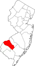 Map of New Jersey highlighting Gloucester County | |
| Boroughs | ||
| Townships | ||
| CDPs | ||
| Other unincorporated communities |
| |
| ||