Enfield Chase
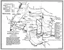
Enfield Chase is a former royal hunting ground in what is now the London Borough of Enfield in north London. Much of the former area of the Chase has been urbanised in modern times but a large part survives between Cockfosters in the west and Enfield Town in the east as Trent Country Park.
| Enfield Chase | |
|---|---|
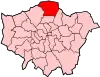
 Enfield Chase Location within Greater London | |
| London borough | |
| Ceremonial county | Greater London |
| Region | |
| Country | England |
| Sovereign state | United Kingdom |
| Post town | ENFIELD |
| Postcode district | EN2 |
| Police | Metropolitan |
| Fire | London |
| Ambulance | London |
| London Assembly | |
Etymology
Enfield Chase was recorded as Enefeld Chacee in 1325 and chace of Enefelde in 1373, from the Middle English chace, meaning "a tract of ground for breeding and hunting wild animals".[4]
History
In the reign of Henry II the parish of Edmonton and adjoining parishes were for the most part a forest which was then so extensive that it reached from the City of London to about 12 miles (19 km) north. Enfield Chase was part of this forest and also belonged to the citizens of London.
By 1154 what had been known as the Park of Enfield or Enfield Wood had been converted into a hunting ground, or chase. It appears it was not known as Enfield Chase until the early 14th century. For hundreds of years the chase was owned at first by the Mandeville and then the de Bohun families while local inhabitants of Edmonton and Enfield manors claimed common rights. It is believed that Princess Elizabeth (later Queen Elizabeth I) often hunted on the Chase after she was granted the estate of West Lodge Park by her brother Edward VI in 1547.[4] In a charter of 1166-89 the hamlet of Southgate, sited around what is now Southgate Underground station, receives a mention. It takes its name from its location at the South Gate of the old hunting ground, later known as Enfield Chase.
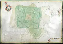
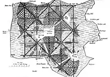
By an act in 1777, the Enfield Chase ceased to exist as an entity. The Chase then covered an area of 8,349 acres (34 km2). By this Act it was cut up and divided among the following authorities:
| To the King | 3,218 acres (13 km2) |
| To the Lodges | 313 acres (1.3 km2) |
| To the Enfranchised | 6 acres (24,000 m2) |
| To the Manor of Old Ford | 36 acres (150,000 m2) |
| To the Manor of Old Park | 30 acres (120,000 m2) |
| To South Mimms Parish | 1,026 acres (4 km2) |
| To Hadley Parish | 240 acres (1.0 km2) |
| To Enfield Parish | 1,732 acres (7 km2) |
| To Edmonton | 1,231 acres (5 km2) |
| To Tithe Owners | 519 acres (2.1 km2) |
It was extensively deforested after the Act, and only a small amount of the original forest remains, although some areas have been replanted.
Boxer's Lake Open Space in Oakwood is one remnant of the Chase.[5]
See also
References and sources
- References
- Pam, David. (1984) The Story of Enfield Chase. Enfield: Enfield Preservation Society. p. 98. ISBN 0907318037
- Dalling, Graham. (1996) Southgate and Edmonton Past: A Study in Divergence. London: Historical Publications. p. 16. ISBN 0948667346.
- 1 item extracted from DL 41/1221 (formerly DL 41/96/26). 'A survey and Admeasurement of... National Archives. Retrieved 21 January 2019.
- Mills A.D. (2010) A Dictionary of London Place-Names. 2nd edition. Oxford: Oxford University Press. p. 85. ISBN 9780199566785
- "Boxer's Lake Open Space". London Gardens Online.
- Sources
- Delvin, S. (1988) A History of Winchmore Hill. Hyperion Press. ISBN 0-7212-0800-2.
- Newby, Herbert W. (1949) "Old" Southgate. London: T. Grove.
External links
![]() Media related to Enfield Chase at Wikimedia Commons
Media related to Enfield Chase at Wikimedia Commons