Ponders End
Ponders End is a commercial and residential district of the London Borough of Enfield situated in the east of the borough.
| Ponders End | |
|---|---|
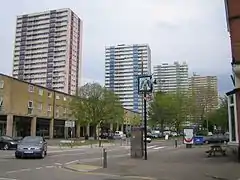 Tower blocks at Alma Road | |
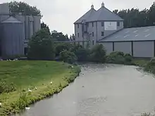
 The Navigation, Ponders End formerly known as the Navigation Inn from the towpath of the River Lee Navigation | |
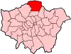
 Ponders End Location within Greater London | |
| OS grid reference | TQ 353 959 |
| London borough | |
| Ceremonial county | Greater London |
| Region | |
| Country | England |
| Sovereign state | United Kingdom |
| Post town | ENFIELD |
| Postcode district | EN1, EN3 |
| Dialling code | 020 |
| Police | Metropolitan |
| Fire | London |
| Ambulance | London |
| UK Parliament | |
| London Assembly | |
Geography
Elevations range from 21 metres (69 ft) to 13 metres (43 ft) above sea level, uniformly dropping from west to east. Two north-south railway lines enclose the residential parts of the area, bounded east and west by estates of warehousing, industrial and commercial use
Its northern and southern limits are along Hertford Road at The Ride and The Boundary pubs (north to south). Its loosely defined east and west limits coalesce around Wharf Road in the east and the Southbury station or Kingsway in the west.[1]
Etymology
Ponders End is marked on the Ordnance Survey map of 1822. It was recorded in 1593 as Ponders ende meaning the "end or quarter of the parish associated with the Ponder family" from the Middle English ende. John Ponder is mentioned in a document of 1373; the surname is believed to mean a "keeper of, or dweller by, a fish-pond or mill-pond".[2]
History
All but a southern belt of the district was in Enfield, as the south lay in Edmonton, the parishes becoming a civil and ecclesiastical after a split of functions in the 1860s, which saw the final secularisation of government, the disestablishment of the vestries following the increase in Poor Law Unions in the hundred years before.[3]
Through the 19th century the area became industrialised, due to its straight road and waterway network up and down the Lea Valley including the 17th century River Lee Navigation.[3] The first major firm to arrive was Grout, Baylis & Co, who were established in Norwich in 1807 as crape manufacturers, the material being used for widows' weeds. They opened a dyeing and finishing plant in Ponders End two years later. Crape went out of fashion by late Victorian times, and the factory closed in 1894. The buildings were taken over by the United Flexible Tubing Company.
In 1866 the London Jute Works Company established a factory on the Navigation in a desolate area known locally as Spike Island. Many of the new employees came from Dundee, the traditional centre of the jute industry in Scotland. The jute works closed in 1882, to be replaced by the Ediswan factory. Over the years the factory was enlarged, eventually covering 11.50 acres (4.65 ha), and employing many people, notably girls, from the area. Ediswan produced electric lamps, and the factory was colloquially known as The Lamp. They also manufactured appliances for the shipping and aviation industries, mechanical pianos and butter makers.
To the south of Ponder's End Lock a factory making white lead was built in 1893. Further south of that factory, the Cortecine works produced floor-cloth and carpet backing. By 1906 over 2000 people were employed in local factories. Another major industry in the latter years of the 19th century was horticulture. Tomatoes and cucumbers were the principal produce but flowers and fruit were also grown in the many orchards and greenhouses to the north of the locality.[4] During World War I, a huge munitions factory, the Ponders End Shell Works was built in Wharf Road. The factory building was sold after the war. Further factories were built in the 1930s alongside the newly built Great Cambridge Road.[5]
Today (2009) little remains of manufacturing and much of the area has given way to warehousing and residential developments. Aesica pharmaceutical manufacturers (formerly Thomas Morson Ltd)[6] closed its plant in 2011.[7] Wright's Flour Mill, the oldest working industrial building in the borough remains, some of its buildings having been constructed in the 18th century.[5]
On 7 August 2011 Ponders End was the scene of copy-cat riots which spread from Tottenham to neighbouring districts.[8]
Popular culture
Musician Jah Wobble was inspired to write his (2005) album Mu by his experiences in the Lea Valley and Ponders End.[9][10]
It's as close as London gets to New Jersey. But it's one of my favourite places for walking, through the Lee Valley. It gets beautiful in that urban way, but then you go through soap factories up near Ponders End. It's got a wonderful, dislocated, alienated feeling
— Jah Wobble
Ponders End Allotments Club is a track from the (1975) Chas and Dave album One Fing 'n' Annuver.[11]
Historic buildings
- Wright's Flour Mill The oldest working industrial building in Enfield.[12]
- Ponders End Pumping Station. Built in 1899 by the East London Waterworks Company.[13] In 1995 the half-timbered building was converted into a public house called the Navigation a Harvester restaurant. Located on the west bank of the Lee Navigation, with views towards the grassed embankment of the King George V Reservoir and close to Ponder's End Lock.[14]
Nearest places
Watercourses
- River Lee Navigation
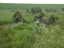
- The Overflow Channel is approximately 2 miles (3.2 km) long. Flowing from the River Lee Navigation above Ponders End Lock across South Marsh close to the King George V Reservoir and following the western perimeter of the William Girling Reservoir to merge with the River Lee Diversion at Edmonton.
Sport
- Angling is allowed on the River Lee Navigation upstream and downstream of Ponders End Lock. Information from the River Lea Anglers Club.[15]
Transport
London Bus Routes 191, 279, 349, 491, 377, 121, 307, 313, 217, 317, 231 and N279 serve the area.
Local rail services
- Lea Valley Lines serving all stations to Hertford East via the Southbury Loop and to Stratford
- West Anglia Main Line stopping services to Bishops Stortford and to Stratford
Demography
The 2011 census showed that 45% of the population was white (26% British, 17% Other, 2% Irish), 16% Black African and 8% Bangladeshi.[16]
Notable people
- James and John Chambers pioneers in South Australia in Stuart expeditions.
- John Hollowbread, footballer
- Christopher Hughes, former Mastermind and International Mastermind winner both in 1983
- Stephen Mangan, actor
- Dave Peacock, musician
- Norman Tebbit, politician
- Chijindu Ujah, Olympic sprinter
Local newspapers
The local newspapers are as of 2011:
Politics
After boundary changes in 2010 - Ponders End became one of seven wards which form the Edmonton parliamentary constituency.[19] The MP for constituency is Kate Osamor.
Schools
- Secondary schools: Oasis Academy Hadley and Heron Hall Academy
- Primary Schools: Kingfisher Hall Primary Academy, St Mary's RC Primary School, Alma Primary School, Southbury Primary School, St Matthew's CoE Primary School,
- Special schools: Waverley School
Higher education
- Middlesex University, Enfield Campus (now closed)
- The College of Haringey, Enfield and North East London
Places of worship
Open spaces
- Ponders End Park, formerly Ponders End Recreation Ground and Ryan's Park.[26]
External links
References
- Local Government Map of Ponders End Boundaries Retrieved 28 February 2008
- Mills, A, D, Oxford Dictionary of London Place Names (2004) p180 ISBN 0-19-860957-4 Retrieved 17 October 2008
- Map of the Edmonton Hundred of Middlesex Victoria County History of Middlesex, Volume 5, A P Baggs, Diane K Bolton, Eileen P Scarff and G C Tyack (1976). Retrieved 2015-02-20
- Godfrey A (notes to) Old Ordnance Survey Maps: Ponders End 1895 Alan Godfrey Maps, ISBN 1-84151-043-2 Retrieved 7 September 2009
- Ponders End history Archived 18 March 2012 at the Wayback Machine Retrieved 19 February 2011
- Thomas Morson Retrieved 8 September 2009
- Plant closure Retrieved 18 April 2011
- News report 8 August 2011
- Hatts, Leigh The Lea Valley Walk p99 ISBN 1-85284-522-8 Retrieved 14 March 2008
- Lea valley walk Retrieved 15 May 2008
- Chas and Dave Archived 24 July 2008 at the Wayback Machine Retrieved 14 May 2008
- History of Enfield Archived 3 April 2008 at the Wayback Machine Retrieved 22 November 2007
- Buildings of England London 4:North by Bridget Cherry & Nikolaus Pevsner pg 451 ISBN 0-14-071049-3
- "Harvester: The Navigation". Harvester.co.uk. Retrieved 17 February 2017.
- River Lea Anglers Club Retrieved 2 December 2014
- http://www.ukcensusdata.com/ponders-end-e05000206
- "News, sport and local information for Enfield and surrounding areas". Enfieldindependent.co.uk. Retrieved 30 June 2011.
- "The Enfield Advertiser". Mediauk.com. Archived from the original on 20 February 2011. Retrieved 30 June 2011.
- Electoral boundaries Archived 14 May 2011 at the Wayback Machine Retrieved 15 April 2011
- St Matthew's Ponders End Archived 3 June 2012 at the Wayback Machine Retrieved 25 May 2011
- Mary Mother of God RC church Archived 6 November 2013 at the Wayback Machine Retrieved 15 December 2010
- Ponders End mosque Retrieved 27 June 2009
- Lincoln Road chapel Retrieved 9 January 2013
- Ponders End Methodist church Retrieved 9 January 2013
- Ponders End United Reformed church Retrieved 9 January 2013
- London Borough of Enfield parks Retrieved 23 July 2014