Mount Girouard
Mount Girouard is the highest peak of the Fairholme Range in Banff National Park, Alberta, Canada. Mt. Girouard is located in the Bow River valley south of Lake Minnewanka.
| Mount Girouard | |
|---|---|
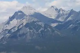 Mount Inglismaldie (left) and Mount Girouard (right) | |
| Highest point | |
| Elevation | 2,995 m (9,826 ft) [1] |
| Prominence | 1,455 m (4,774 ft) [2] |
| Listing | List of mountains of Alberta |
| Coordinates | 51°14′10″N 115°24′11″W [3] |
| Geography | |
 Mount Girouard Location in Alberta | |
| Location | Alberta, Canada |
| Parent range | Fairholme Range |
| Topo map | NTS 82O/03 |
| Climbing | |
| First ascent | 1938 by E.E. Bishop and D.R. Crosby[1][2] |
| Easiest route | rock climb |
The mountain was named in 1904 after Sir Édouard Girouard, a railway builder in Africa during the rule of the British Empire.[1][2]
Geology
Mount Girouard is composed of sedimentary rock laid down during the Precambrian to Jurassic periods. Formed in shallow seas, this sedimentary rock was pushed east and over the top of younger rock during the Laramide orogeny.[4]
Climate
Based on the Köppen climate classification, Mount Girouard is located in a subarctic climate with cold, snowy winters, and mild summers.[5] Temperatures can drop below −20 °C (−4 °F) with wind chill factors below −30 °C (−22 °F). Precipitation runoff from the mountain drains into the Bow River.
See also
References
- "Mount Girouard". PeakFinder.com. Retrieved 2004-09-29.
- "Mount Girouard". Bivouac.com. Retrieved 2008-05-25.
- "Mount Girouard". Geographical Names Data Base. Natural Resources Canada. Retrieved 2019-08-02.
- Gadd, Ben (2008). "Geology of the Rocky Mountains and Columbias". Cite journal requires
|journal=(help) - Peel, M. C.; Finlayson, B. L. & McMahon, T. A. (2007). "Updated world map of the Köppen−Geiger climate classification". Hydrol. Earth Syst. Sci. 11: 1633–1644. ISSN 1027-5606.
External links
- Mount Girouard weather: Mountain Forecast