Fisher Peak (Alberta)
Fisher Peak is a 3,053-metre (10,016-foot) mountain summit located in the Fisher Range of Kananaskis Country in the Canadian Rockies of Alberta, Canada. Fisher Peak is the highest point in the Fisher Range, so its nearest higher peak is Mount Evan-Thomas, 7.0 km (4.3 mi) to the southwest in the Opal Range.[1] Precipitation runoff from the mountain drains west into Evan-Thomas Creek, which is a tributary of the Kananaskis River, or east into the Little Elbow River which is a tributary of the Elbow River.
| Fisher Peak | |
|---|---|
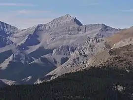 Fisher Peak seen from Nihahi Ridge | |
| Highest point | |
| Elevation | 3,053 m (10,016 ft) [1][2][3] |
| Prominence | 904 m (2,966 ft) [1] |
| Parent peak | Mount Evan-Thomas (3098 m)[1] |
| Listing | Mountains of Alberta |
| Coordinates | 50°48′52″N 115°01′48″W [4] |
| Geography | |
 Fisher Peak Location of Fisher Peak in Alberta  Fisher Peak Fisher Peak (Canada) | |
| Location | Alberta, Canada |
| Parent range | Fisher Range[1] Canadian Rockies |
| Topo map | NTS 82J/14[4] |
| Geology | |
| Age of rock | Cambrian |
| Type of rock | sedimentary rock |
| Climbing | |
| First ascent | 1950 J.F. Tarrant[1] |
| Easiest route | Difficult, exposed Scramble[5][2] |
History
The peak was named in 1920 after John Arbuthnot Fisher, 1st Baron Fisher, a British admiral known for reforming and modernizing the Royal Navy prior to World War I.[1] Jackie Fisher, as he was commonly known, has been considered the second most important person in British naval history. The mountain's name was officially adopted by the Geographical Names Board of Canada in 1924.[4]
The first ascent of the mountain was made in 1950 by J.F. Tarrant.[1]
Geology
Fisher Peak is composed of sedimentary rock laid down during the Precambrian to Jurassic periods. Formed in shallow seas, this sedimentary rock was pushed east and over the top of younger rock during the Laramide orogeny.[6]
Climate
Based on the Köppen climate classification, Fisher Peak is located in a subarctic climate with cold, snowy winters, and mild summers.[7] Temperatures can drop below −20 °C with wind chill factors below −30 °C. In terms of favorable weather, June through September are the best months to climb.
References
- "Fisher Peak". Bivouac.com. Retrieved 2019-03-25.
- Kane, Alan (2016). "Fisher Peak". Scrambles in the Canadian Rockies (3rd ed.). Calgary: Rocky Mountain Books. Kindle Edition. ISBN 978-1-77160-098-9.
- Kananaskis Lakes (Map). 1:50,000. Cochrane, AB: Gem Trek Publishing. 2001. § A4. ISBN 1-895526-24-8. Retrieved 2020-08-03.
- "Fisher Peak". Geographical Names Data Base. Natural Resources Canada. Retrieved 2019-03-25.
- "Fisher Peak (Kananaskis)". explor8ion.com. Retrieved 2020-08-03.
- Gadd, Ben (2008), Geology of the Rocky Mountains and Columbias
- Peel, M. C.; Finlayson, B. L. & McMahon, T. A. (2007). "Updated world map of the Köppen−Geiger climate classification". Hydrol. Earth Syst. Sci. 11: 1633–1644. ISSN 1027-5606.
External links
- Climbing Fisher Peak: Explor8ion.com
- Fisher Peak photo: Flickr