Fourquevaux
Fourquevaux is a commune in the Haute-Garonne department in southwestern France.
Fourquevaux | |
|---|---|
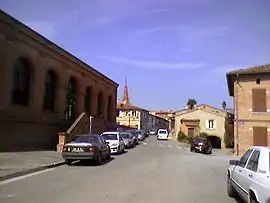 A view within Fourquevaux | |
.svg.png.webp) Coat of arms | |
Location of Fourquevaux 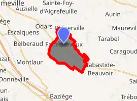
| |
 Fourquevaux  Fourquevaux | |
| Coordinates: 43°30′27″N 1°37′03″E | |
| Country | France |
| Region | Occitanie |
| Department | Haute-Garonne |
| Arrondissement | Toulouse |
| Canton | Escalquens |
| Intercommunality | Sicoval |
| Government | |
| • Mayor (2008–2014) | Henri Valés |
| Area 1 | 10.03 km2 (3.87 sq mi) |
| Population (2017-01-01)[1] | 771 |
| • Density | 77/km2 (200/sq mi) |
| Time zone | UTC+01:00 (CET) |
| • Summer (DST) | UTC+02:00 (CEST) |
| INSEE/Postal code | 31192 /31450 |
| Elevation | 165–256 m (541–840 ft) (avg. 230 m or 750 ft) |
| 1 French Land Register data, which excludes lakes, ponds, glaciers > 1 km2 (0.386 sq mi or 247 acres) and river estuaries. | |
Population
|
|
Sights
The Château de Fourquevaux is a 15th- and 16th-century castle. With its 18th-century orangery, it has been listed since 1979 as a historic site by the French Ministry of Culture.[2]
References
- "Populations légales 2017". INSEE. Retrieved 6 January 2020.
- Base Mérimée: Château de Fourquevaux, Ministère français de la Culture. (in French)
| Wikimedia Commons has media related to Fourquevaux. |
| Authority control |
|---|
This article is issued from Wikipedia. The text is licensed under Creative Commons - Attribution - Sharealike. Additional terms may apply for the media files.