Lévignac
Lévignac, also known as Lévignac-sur-Save, is a commune in the Haute-Garonne department in southwestern France.
Lévignac-sur-Save | |
|---|---|
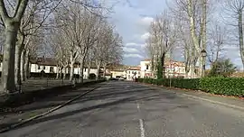 The Place du Padouenc in Lévignac | |
.svg.png.webp) Coat of arms | |
Location of Lévignac-sur-Save 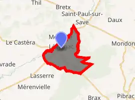
| |
 Lévignac-sur-Save  Lévignac-sur-Save | |
| Coordinates: 43°40′01″N 1°11′43″E | |
| Country | France |
| Region | Occitanie |
| Department | Haute-Garonne |
| Arrondissement | Toulouse |
| Canton | Léguevin |
| Intercommunality | Save au Touch |
| Government | |
| • Mayor (2008–2014) | Jean-Jacques Siméon |
| Area 1 | 12.22 km2 (4.72 sq mi) |
| Population (2017-01-01)[1] | 2,113 |
| • Density | 170/km2 (450/sq mi) |
| Time zone | UTC+01:00 (CET) |
| • Summer (DST) | UTC+02:00 (CEST) |
| INSEE/Postal code | 31297 /31530 |
| Elevation | 123–235 m (404–771 ft) (avg. 137 m or 449 ft) |
| 1 French Land Register data, which excludes lakes, ponds, glaciers > 1 km2 (0.386 sq mi or 247 acres) and river estuaries. | |
Population
| Year | Pop. | ±% |
|---|---|---|
| 1962 | 668 | — |
| 1968 | 748 | +12.0% |
| 1975 | 886 | +18.4% |
| 1982 | 1,080 | +21.9% |
| 1990 | 1,400 | +29.6% |
| 1999 | 1,624 | +16.0% |
| 2008 | 2,032 | +25.1% |
Transportation
Lévignac lies on the Itinéraire à Grand Gabarit, the route created specially for the oversized road conveys conveying fuselage and wing sections of the Airbus A380 airliner to Toulouse for final assembly. The convoys, which run overnight at up to weekly frequency, travel down the main street of the town, with only centimetres clearance from the adjacent buildings. Major works on the main street were required to permit this, including new pedestrian paths, parking areas and lighting.[2][3]
References
- "Populations légales 2017". INSEE. Retrieved 6 January 2020.
- "Convoi Exceptionnel". Airliner World. Key Publishing Limited. May 2009.
- "Itinéraire à grand gabarit : Transport des pièces de l'Airbus A380 entre Langon et Toulouse : Aménagements réalisés à Lévignac" (in French). IGG.FR. Archived from the original on 2011-07-20. Retrieved 2010-08-09.
| Wikimedia Commons has media related to Lévignac (Haute-Garonne). |
| Authority control |
|---|
This article is issued from Wikipedia. The text is licensed under Creative Commons - Attribution - Sharealike. Additional terms may apply for the media files.