Labarthe-sur-Lèze
Labarthe-sur-Lèze is a commune in the Haute-Garonne department in southwestern France.
Labarthe-sur-Lèze | |
|---|---|
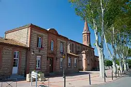 The town hall in Labarthe-sur-Lèze | |
 Coat of arms | |
Location of Labarthe-sur-Lèze 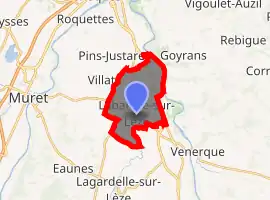
| |
 Labarthe-sur-Lèze  Labarthe-sur-Lèze | |
| Coordinates: 43°27′10″N 1°24′03″E | |
| Country | France |
| Region | Occitanie |
| Department | Haute-Garonne |
| Arrondissement | Muret |
| Canton | Portet-sur-Garonne |
| Intercommunality | Muretain |
| Government | |
| • Mayor (2008–2014) | Bernard Bérail |
| Area 1 | 10.43 km2 (4.03 sq mi) |
| Population (2017-01-01)[1] | 6,178 |
| • Density | 590/km2 (1,500/sq mi) |
| Time zone | UTC+01:00 (CET) |
| • Summer (DST) | UTC+02:00 (CEST) |
| INSEE/Postal code | 31248 /31860 |
| Elevation | 151–173 m (495–568 ft) (avg. 162 m or 531 ft) |
| 1 French Land Register data, which excludes lakes, ponds, glaciers > 1 km2 (0.386 sq mi or 247 acres) and river estuaries. | |
Geography
The Lèze forms part of the commune's southern border, flows northward through the eastern part of the commune, then flows into the Ariège, which forms the commune's northeastern border.
Population
|
|
References
- "Populations légales 2017". INSEE. Retrieved 6 January 2020.
| Wikimedia Commons has media related to Labarthe-sur-Lèze. |
| Authority control |
|---|
This article is issued from Wikipedia. The text is licensed under Creative Commons - Attribution - Sharealike. Additional terms may apply for the media files.