Saint-Lys
Saint-Lys (Sent Lis in gascon occitan) is a commune in the Haute-Garonne department in southwestern France.
Saint-Lys | |
|---|---|
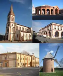 The church, market hall, city hall, multimedia library and the windmill. | |
.svg.png.webp) Coat of arms | |
Location of Saint-Lys 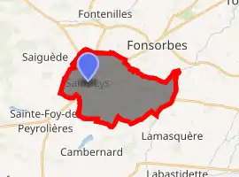
| |
 Saint-Lys  Saint-Lys | |
| Coordinates: 43°30′54″N 1°10′42″E | |
| Country | France |
| Region | Occitanie |
| Department | Haute-Garonne |
| Arrondissement | Muret |
| Canton | Plaisance-du-Touch |
| Intercommunality | Muretain |
| Government | |
| • Mayor (2020–2026) | Serge Deuilhé[1] |
| Area 1 | 21.3 km2 (8.2 sq mi) |
| Population (2017-01-01)[2] | 9,470 |
| • Density | 440/km2 (1,200/sq mi) |
| Time zone | UTC+01:00 (CET) |
| • Summer (DST) | UTC+02:00 (CEST) |
| INSEE/Postal code | 31499 /31470 |
| Elevation | 175–220 m (574–722 ft) (avg. 209 m or 686 ft) |
| 1 French Land Register data, which excludes lakes, ponds, glaciers > 1 km2 (0.386 sq mi or 247 acres) and river estuaries. | |
Population
|
|
References
- "Répertoire national des élus: les maires". data.gouv.fr, Plateforme ouverte des données publiques françaises (in French). 2 December 2020. Retrieved 7 December 2020.
- "Populations légales 2017". INSEE. Retrieved 6 January 2020.
| Wikimedia Commons has media related to Saint-Lys. |
| Authority control |
|
|---|
This article is issued from Wikipedia. The text is licensed under Creative Commons - Attribution - Sharealike. Additional terms may apply for the media files.
