Geography of Denmark
Denmark is a Nordic country located in Northern Europe. It consists of the Jutland peninsula and several islands in the Baltic sea, referred to as the Danish Archipelago. Denmark is located southwest of Sweden and due south of Norway and is bordered by the German state (and former possession) Schleswig-Holstein to the south, on Denmark's only land border, 68 kilometres (42 miles) long.
 | |
| Continent | Europe |
|---|---|
| Region | Northern Europe |
| Coordinates | 56°00′N 10°00′E |
| Area | |
| • Total | 43,094 km2 (16,639 sq mi) |
| • Land | 98% |
| • Water | 2% |
| Coastline | 8,750 km (5,440 mi) |
| Borders | Total land borders: 68 km |
| Highest point | Møllehøj 171 m |
| Lowest point | Lammefjord -7 m |
| Longest river | Gudenå 149 km |
| Largest lake | Arresø 40.72 km² |
| Exclusive economic zone | 105,989 km2 (40,923 sq mi) (excludes Greenland and Faroe Islands) |
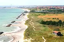
Denmark borders both the Baltic and North Seas along its 8,750 km (5,440 mi) tidal shoreline. Denmark's general coastline is much shorter, at 1,701 km (1,057 mi), as it would not include most of the 1,419 offshore islands (each defined as exceeding 100 square metres in area) and the 180 km long Limfjorden, which separates Denmark's second largest island, North Jutlandic Island, 4,686 km2 in size, from the rest of Jutland. No location in Denmark is further from the coast than 52 km (32 mi). The land area of Denmark is estimated to be 43,094 km2 (16,639 sq mi). However, it cannot be stated exactly since the ocean constantly erodes and adds material to the coastline, and there are human land reclamation projects. On the southwest coast of Jutland, the tide is between 1 and 2 m (3.28 and 6.56 ft), and the tideline moves outward and inward on a 10 km (6.2 mi) stretch.[1] Denmark has an Exclusive Economic Zone of 105,989 km2 (40,923 sq mi). When including Greenland and the Faroe Islands the EEZ is the 15th largest in the world with 2,220,093 km2 (857,183 sq mi).
A circle enclosing the same total area as Denmark would have a diameter of 234 km (146 miles). Denmark has 443 named islands (1,419 islands above 100 m2),[2] of which 72 are inhabited (as of 1 January 2007, Statistics Denmark). The largest islands are Zealand (Sjælland) and Funen (Fyn). The island of Bornholm is located east of the rest of the country, in the Baltic Sea. Many of the larger islands are connected by bridges; the Øresund Bridge connects Zealand with Sweden; the Great Belt Bridge connects Funen with Zealand; and the Little Belt Bridge connects Jutland with Funen. Ferries or small aircraft connect to the smaller islands. Main cities are the capital Copenhagen on Zealand; Århus, Aalborg and Esbjerg in Jutland; and Odense on Funen.
Denmark experiences a temperate climate. This means that the winters are mild and windy and the summers are cool. The local terrain is generally flat with a few gently rolling plains. The territory of Denmark includes the island of Bornholm in the Baltic Sea and the rest of metropolitan Denmark, but excludes the Faroe Islands and Greenland. Its position gives Denmark complete control of the Danish Straits (Skagerrak and Kattegat) linking the Baltic and North Seas. The country's natural resources include petroleum, natural gas, fish, salt, limestone, chalk, stone, gravel and sand.
Environment


Climate
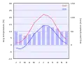 Climate chart of Copenhagen.
 Climate of Denmark according to the Köppen climate classification.
| Climate data for Denmark (extremes, most 1961-1990) | |||||||||||||
|---|---|---|---|---|---|---|---|---|---|---|---|---|---|
| Month | Jan | Feb | Mar | Apr | May | Jun | Jul | Aug | Sep | Oct | Nov | Dec | Year |
| Record high °C (°F) | 11.8 (53.2) |
15.8 (60.4) |
22.2 (72.0) |
26.2 (79.2) |
31.0 (87.8) |
35.5 (95.9) |
35.3 (95.5) |
36.4 (97.5) |
29.8 (85.6) |
24.0 (75.2) |
19.6 (67.3) |
13.0 (55.4) |
36.4 (97.5) |
| Record low °C (°F) | −31.2 (−24.2) |
−29.0 (−20.2) |
−27.0 (−16.6) |
−12.1 (10.2) |
−6.0 (21.2) |
−1.6 (29.1) |
1.0 (33.8) |
−0.1 (31.8) |
−4.4 (24.1) |
−9.0 (15.8) |
−19.0 (−2.2) |
−25.6 (−14.1) |
−31.2 (−24.2) |
Land use
- Arable land: 55.99% Permanent crops: 0.14% Other: 42.87% (2012)
Irrigated land: 4,354 km2 (2007)
Total renewable water resources: 6 km3 (2011)
Freshwater withdrawal (domestic/industrial/agricultural):
total: 0.66 km3/yr (58%/5%/36%)
per capita: 118.4 m3/yr (2009)
Agriculture
- Denmark has plenty of rain, flat landscape, and moderate climate. With 55.99% of its land considered as arable, Denmark has model characteristics for agriculture. 61% of the country's total area is cultivated [3] Farms in Denmark are remarkably large, averaging 172.9 acres per farm. Additionally, homesteads exceeding 247 acres make up more than 20% in Denmark. Many of these large farms harvest fruits and vegetables, the leading exports from Denmark are meat, fur, and dairy products.[3] The animal's diets in Denmark consist of mainly cereals since they are the dominant field crop. 75% of all cereal produced in Denmark is feed to the four most produced animals which are pigs, cattle, chicken and mink.[3] Denmark overproduces about 66% of food production compared to their own population size (5.7 million) being that they are able to feed 15 million people. This is a byproduct of being highly productive within the Danish agricultural production.[3]
- In 1961, Denmark's Agricultural land represented 74.5% of land area. Fifty-six years later to 2015, Denmark has decreased its amount of Agricultural land down to 62.1%[4] then to 61% one year later in reference to "Facts and Figures - Danish Agriculture and Food"[3] The decrease in agricultural land comes as farmers are being well educated and the intensive amount of research and development is being implemented. It begins with advancements in agro-technology. The results have improved fertilization and nutrient use on arable land. Digestibility and nutrient uptake are developing from the improvements of new methods that are being implemented. Examples of these new methods are the addition of enzymes and microbial cultures.[3]
Natural hazards
- Flooding is a threat in some areas of the country
Current issues
- Air pollution, principally from vehicle and power plant emissions
- Nitrogen and phosphorus pollution of the North Sea
- Drinking and surface water becoming polluted from animal wastes and pesticides
International agreements
- Party to: Air Pollution, Air Pollution-Nitrogen Oxides,
Air Pollution-Sulphur 85, Air Pollution-Sulphur 94, Air Pollution-Volatile Organic Compounds, Antarctic Treaty, Biodiversity, Climate Change, Desertification, Endangered Species, Environmental Modification, Hazardous Wastes, Law of the Sea, Marine Dumping, Marine Life Conservation, Nuclear Test Ban, Ozone Layer Protection, Ship Pollution, Tropical Timber 83, Tropical Timber 94, Wetlands, Whaling - Signed, but not ratified: Air Pollution-Persistent Organic Pollutants, Antarctic-Environmental Protocol, Climate Change-Kyoto Protocol
- Party to: Air Pollution, Air Pollution-Nitrogen Oxides,
Transnational issues
Maritime claims
- Contiguous zone: 24 nmi (44.4 km; 27.6 mi)
Continental shelf: 200-m depth or to the depth of exploitation Exclusive economic zone: 105,989 km2 (40,923 sq mi) (excludes Greenland and Faroe Islands). 200 nmi (370.4 km; 230.2 mi) Territorial sea: 12 nmi (22.2 km; 13.8 mi)
Other issues
- Iceland disputes the Faroe Islands' fisheries median line.
- Iceland, Ireland and the United Kingdom dispute Denmark's claim that the Faroe Islands' continental shelf extends beyond 200 nautical miles or about 370 km.
- The Faroe Islands continue to study proposals for full independence.
- Uncontested sovereignty dispute with Canada over Hans Island in the Kennedy Channel between Ellesmere Island and Greenland.
- Denmark is currently investigating the extent of the continental shelf of Greenland, in the hope that Greenland's Exclusive Economic Zone can be expanded. One of the areas investigated is the geographical North Pole.
Population
Urban population
- Denmark's urban population accounts for 87.9% of its total population, with a 0.51% rate of change in urbanization.[5] Copenhagen remains the largest city in Denmark with a population of 1.2 million people and a metro population of 1.99 million. Copenhagen became Denmark's Capital in 1443 and now currently sits with a population density of 6,800 people per square kilometer.[6][7]
- About a quarter of Danes live in the capital Copenhagen.[8]
Notes
- Footnotes
- Nationalencyklopedin, (1990)
- Islands in total and named islands
- "FACTS AND FIGURES: Danish Agriculture and Food".
- "Agricultural land (% of land area) | Data". data.worldbank.org. Retrieved 2018-11-29.
- "The World Factbook — Central Intelligence Agency". www.cia.gov. Retrieved 2018-10-12.
- "Denmark Population 2018 (Demographics, Maps, Graphs)". worldpopulationreview.com. Retrieved 2018-10-12.
- "A brief history of Copenhagen". VisitDenmark (in Lingala). Retrieved 2018-10-31.
- "Copenhagen Population 2020". worldpopulationreview.com. Retrieved 2019-01-25.
- Reference
The World Book Encyclopedia (2003 ed.). 1974. ISBN 0716601036.
External links
![]() Media related to Geography of Denmark at Wikimedia Commons
Media related to Geography of Denmark at Wikimedia Commons
- Map of Denmark from the Atlas “Theatrum orbis terrarum” by Abraham Ortelius. It's the first printed map of Denmark.