Geography of France
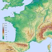
The geography of France consists of a terrain that is mostly flat plains or gently rolling hills in the north and west and mountainous in the south (including the Pyrenees) and the east (the highest points being in the Alps). Metropolitan France has a total size of 551,695 km2 (213,011 sq mi) (Europe only). It is the third largest country in Europe after Russia and Ukraine.
 | |
| Continent | Europe |
|---|---|
| Region | Western Europe |
| Coordinates | 48°51′N 2°21′E |
| Area | Ranked 42nd |
| • Total | 551,695 km2 (213,011 sq mi) |
| • Land | 99.48% |
| • Water | 0.52% |
| Coastline | 3,427 km (2,129 mi) |
| Borders | 4,176 km (2,595 mi) |
| Highest point | Mont Blanc 4,808 m (15,774 ft) |
| Lowest point | Étang de Lavalduc −10 m (−33 ft) |
| Longest river | Loire 1,012 km (629 mi) |
| Largest lake | Lac du Bourget 44.5 km (27.7 mi) |
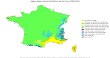
| Climate | oceanic climate (west), semi-continental climate (north and north-east), lower Rhône valley Mediterranean climate, mountain climate in the Alps and Pyrenees. |
| Terrain | Mostly flat plains or gently rolling hills in the north and west and mountainous in the south |
| Natural Resources | Coal, iron ore, bauxite, zinc, uranium, antimony, arsenic, potash, feldspar, fluorspar, gypsum, timber, fish, gold |
| Natural Hazards | Flooding, avalanches, midwinter windstorms, drought, forest fires in the south near the Mediterranean |
| Environmental Issues | Water pollution from public wastes, air pollution from industrial and vehicle exhaust, agricultural runoff, forest damage due to acid rain. |
| Exclusive economic zone | In Europe: 334,604 km2 (129,191 sq mi) All overseas territories: 11,691,000 km2 (4,514,000 sq mi) |
Physical geography of Metropolitan France
- Metropolitan France: 551,695 km2 (213,011 sq mi)
- (Metropolitan - i.e. European - France only, French National Geographic Institute data?
- Metropolitan France: 543,965 km2
- (Metropolitan - i.e. European - France only, French Land Register data, which exclude lakes, ponds, glaciers larger than 1 km2
, and estuaries)
- (Metropolitan - i.e. European - France only, French Land Register data, which exclude lakes, ponds, glaciers larger than 1 km2
Elevation extremes
- Lowest point: Étang de Lavalduc, Bouches-du-Rhône -10 m
- Highest point: Mont Blanc 4,808 m
Land use
- Arable land: 33.40%
- Permanent crops: 1.83%
- Other: 64.77% (2007)
Irrigated land: 26,420 km² (2007)
Total renewable water resources: 211 km3 (2011)
Freshwater withdrawal (domestic/industrial/agricultural): 31.62 km3/yr (19%/71%/10%) (512.1 m3/yr per capita) (2009)
Natural resources
Coal, iron ore, bauxite, zinc, uranium, antimony, arsenic, potash, feldspar, fluorspar, gypsum, timber, fish, gold, clay, petroleum
Natural hazards
Flooding, avalanches, midwinter windstorms, drought, forest fires in the south near the Mediterranean
Environment
The region that now comprises France consisted of open grassland during the Pleistocene Ice Age. France gradually became forested as the glaciers retreated starting in 10,000 BC, but clearing of these primeval forests began in Neolithic times. These forests were still fairly extensive until the medieval era.
In prehistoric times, France was home to large predatory animals such as wolves and brown bears, as well as herbivores such as elk. The larger fauna have disappeared outside the Pyrenees Mountains where bears live as a protected species. Smaller animals include martens, wild pigs, foxes, weasels, bats, rodents, rabbits, and assorted birds.
By the 15th century, France had largely been denuded of its forests and was forced to rely on Scandinavia and their North American colonies for lumber. Significant remaining forested areas are in the Gascony region and north in the Alsace-Ardennes area. The Ardennes Forest was the scene of extensive fighting in both world wars.
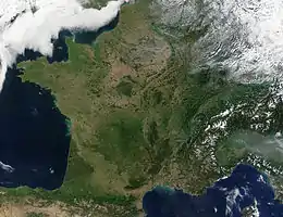
The upper central part of this region is dominated by the Paris Basin, which consists of a layered sequence of sedimentary rocks. Fertile soils over much of the area make good agricultural land. The Normandy coast to the upper left is characterized by high, chalk cliffs, while the Brittany coast (the peninsula to the left) is highly indented where deep valleys were drowned by the sea, and the Biscay coast to the southwest is marked by flat, sandy beaches.
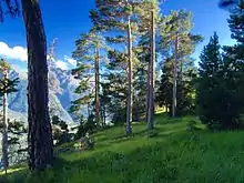 Forest in Sollières-Sardières (Natura 2000 site).
.jpg.webp)
 Mont Blanc, the highest summit in Western Europe
Mont Blanc, the highest summit in Western Europe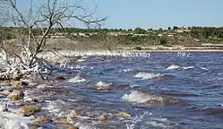 Étang de Lavalduc, the lowest point in France
Political geography
Internal divisions
-2016.svg.png.webp)
France has several levels of internal divisions. The first-level administrative division of Integral France is regions. Besides this the French Republic has sovereignty over several other territories, with various administrative levels.
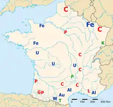
- Metropolitan (i.e. European) France is divided into 12 régions and 1 territorial collectivity, Corsica. However, Corsica is referred to as a region in common speech. These regions are subdivided into 96 départements, which are further divided into 332 arrondissements, which are further divided into 3,879 cantons, which are further divided into 36,568 communes (as of 1/1/2004).
- Five overseas regions (régions d'outre-mer, or ROM): Guadeloupe, French Guiana, Martinique, Mayotte, and Réunion, with identical status to metropolitan regions. Each of these overseas regions also being an overseas département (département d'outre-mer, or DOM), with the same status as a département of metropolitan France. This double structure (région/département) is new, due to the recent extension of the regional scheme to the overseas départements, and may soon transform into a single structure, with the merger of the regional and departmental assemblies. Another proposed change is that new départements are created such as in the case of Réunion, where it has been proposed to create a second département in the south of the island, with the région of Réunion above these two départements.
- Four overseas collectivities (collectivités d'outre-mer, or COM): Saint-Pierre and Miquelon, Saint Barthélemy, Saint Martin, and Wallis and Futuna.
- One overseas "country" (pays d'outre-mer, or POM): French Polynesia. In 2003 it became an overseas collectivity (or COM). Its statutory law of 27 February 2004 gives it the particular designation of overseas country inside the Republic (or POM), but without legal modification of its status.
- One sui generis collectivity (collectivité sui generis): New Caledonia, whose status is unique in the French Republic.
- One overseas territory (territoire d'outre-mer, or TOM): the French Southern and Antarctic Lands divided into 5 districts: Kerguelen Islands, Crozet Islands, Île Amsterdam and Île Saint-Paul, Adélie Land, and the Scattered islands (Banc du Geyser, Bassas da India, Europa, Juan de Nova, Glorioso, and Tromelin).
- One uninhabited island in the Pacific Ocean off the coast of Mexico which belongs directly to the central State public land and is administered by the high-commissioner of the French Republic in French Polynesia: Clipperton.
Boundaries
- Land boundaries:
- Total: 3,966.2 kilometres (2,464.5 mi)
- 2,751 kilometres (1,709 mi) (metropolitan), 1,205 kilometres (749 mi) (French Guiana) 10.2 kilometres (6.3 mi) (Saint Martin)
- Border countries:
- Andorra 55 kilometres (34 mi), Belgium 556 kilometres (345 mi), Germany 418 kilometres (260 mi), Italy 476 kilometres (296 mi), Luxembourg 69 kilometres (43 mi), Monaco 6 kilometres (3.7 mi), Spain 646 kilometres (401 mi), Switzerland 525 kilometres (326 mi) (metropolitan)
- Brazil 649 kilometres (403 mi), Suriname 556 kilometres (345 mi), 1,183 kilometres (735 mi) (French Guiana)
- Sint Maarten 10.2 kilometres (6.3 mi) (Saint Martin)
- Coastline: 3,427 kilometres (2,129 mi) (metropolitan), 378 kilometres (235 mi) (French Guiana), 306 kilometres (190 mi) (Guadeloupe), 350 kilometres (220 mi) (Martinique), 207 kilometres (129 mi) (Réunion)
- Maritime claims:
- Territorial sea: 12 nmi (22.2 km; 13.8 mi)
- Contiguous zone: 24 nmi (44.4 km; 27.6 mi)
- Exclusive economic zone: 334,604 km2 (129,191.3 sq mi) only in Europe. 11,691,000 km2 (4,513,920.3 sq mi) including all overseas territories. The 200 nmi (370.4 km; 230.2 mi) does not apply to the Mediterranean Sea
- Continental shelf: 200 metres (660 ft) depth or to the depth of exploitation
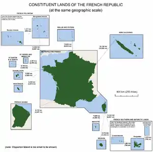 The lands making up the French Republic, shown at the same geographic scale.
 French Guiana
 The exclusive economic zones of France
Extreme points
This is a list of the extreme points of France; the points that are farther north, south, east or west than any other location.
France (mainland Europe)
- Northernmost point — Bray-Dunes, Nord at 51°05′N 2°32′E
- Southernmost point — Puig de Comanegra, Lamanère, Pyrénées-Orientales at 42°20′N 2°31′E
- Westernmost point — Pointe de Corsen, Plouarzel, Finistère at 48°24′N 4°47′W
- Easternmost point — Lauterbourg, Bas Rhin at 48°58′N 8°13′E
France (metropolitan)
- Northernmost point — Bray-Dunes, Nord at 51°05′N 2°32′E
- Southernmost point — Îles Lavezzi (off Corsica), Bonifacio, Corse-du-Sud at 41°20′N 9°15′E
- Westernmost point — Isle of Ushant (off Brittany), Finistère at 48°27′N 5°08′W
- Easternmost point — San-Giuliano (near Cervione), Haute-Corse at 42°17′N 9°33′E
France (including départements d'outre mer)
- Northernmost point — Bray-Dunes, Nord at 51°05′N 2°32′E
- Westernmost point — Pointe-Noire, Guadeloupe at 16°16′N 61°48′W
- Easternmost point — Sainte-Rose, Réunion at 21°11′S 55°50′E
France (territory of the French Republic, including collectivités territoriales and pays et territoires d'outre-mer)
- Northernmost point : Bray-Dunes, Nord at 51°05′N 2°32′E
- Southernmost point : îles de Boynes, Kerguelen Islands, French Southern and Antarctic Lands at 50°01′S 68°52′E
- Westernmost point : Toloke, Futuna, Wallis and Futuna at 14°42′S 178°33′W
- Easternmost point : Hunter Island, New Caledonia at 22°31′S 172°6′E
Temperature Extremes
These are the extreme temperatures in France.
| Climate data for France | |||||||||||||
|---|---|---|---|---|---|---|---|---|---|---|---|---|---|
| Month | Jan | Feb | Mar | Apr | May | Jun | Jul | Aug | Sep | Oct | Nov | Dec | Year |
| Record high °C (°F) | 23.3 (73.9) |
28.3 (82.9) |
29.2 (84.6) |
32.1 (89.8) |
35.6 (96.1) |
45.9 (114.6) |
43.9 (111.0) |
44.1 (111.4) |
38.0 (100.4) |
35.8 (96.4) |
27.1 (80.8) |
26.9 (80.4) |
45.9 (114.6) |
| Record low °C (°F) | −41.0 (−41.8) |
−35 (−31) |
−32.0 (−25.6) |
−19.0 (−2.2) |
−10 (14) |
−4.0 (24.8) |
−4.0 (24.8) |
−4.0 (24.8) |
−7.0 (19.4) |
−14.0 (6.8) |
−29.0 (−20.2) |
−37.0 (−34.6) |
−41.0 (−41.8) |
See also
- Regions of France
- List of fifteen largest French metropolitan areas by population
- Géoportail
- Institut géographique national
Lists:
- List of islands of France
- List of lakes in France
- List of national parks of France
- Rivers of France
General:
External links
| Wikibooks has more on the topic of: Geography of France |
- (in French) GéoPortail - Geography portal of France, high altitude imagery, maps ...
- A detailed map of France showing all régions and numbered départements, including their préfectures.
| History |
|  | ||||
|---|---|---|---|---|---|---|
| Geography | ||||||
| Politics | ||||||
| Economy | ||||||
| Society |
| |||||
| ||||||