Geography of Jersey
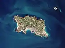
Jersey (Jèrriais: Jèrri) is the largest of the Channel Islands, an island archipelago in the English Channel. It has a total area of 120 square kilometres (45 sq mi) and is part of the British Isles archipelago. It lies 22 km (12 nmi; 14 mi) from the Cotenin Peninsula in Normandy, France and about 161 km (87 nmi; 100 mi) from the south coast of Great Britain. Jersey lies within longitude -2° W and latitude 49° N.
| Native name: Jèrri | |
|---|---|
 Map of islands of Bailiwick of Jersey | |
 Jersey | |
| Geography | |
| Location | English Channel |
| Coordinates | 49°11′24.06″N 2°6′36″W |
| Archipelago | Channel Islands |
| Area | 119.49 km2 (46.14 sq mi) |
| Length | 14 km (8.7 mi) |
| Width | 8 km (5 mi) |
| Coastline | 70 km (43 mi) |
| Highest elevation | 143 m (469 ft) |
| Highest point | Les Platons |
| Administration | |
United Kingdom | |
| Crown dependency | Jersey |
| Capital city | Saint Helier |
| Largest settlement | Saint Helier |
| Demographics | |
| Population | 99,500[1] (2013) |
| Pop. density | 819/km2 (2121/sq mi) |
| Ethnic groups | English and Norman-French descent. Portuguese and Polish minorities |
It has a coastline of 70 kilometres and no land connections to any other territories. Jersey claims a territorial sea of 3 nmi (5.6 km; 3.5 mi) and an exclusive fishing zone of 12 nmi (22.2 km; 13.8 mi) and shares maritime borders with the Bailiwick of Guernsey to the north and France to the south and east.
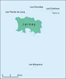
Jersey is the main island of the Bailiwick of Jersey, which also consists of islet groups known as Les Écréhous, Les Minquiers, Les Dirouilles and Les Pierres de Lecq.
It is a highly densely populated territory, being the 13th most densely populated country or territory.[2] About 30% of the population of the island is concentrated in the parish of Saint Helier, which contains the main town of the island.
Climate
| Climate data for Jersey | |||||||||||||
|---|---|---|---|---|---|---|---|---|---|---|---|---|---|
| Month | Jan | Feb | Mar | Apr | May | Jun | Jul | Aug | Sep | Oct | Nov | Dec | Year |
| Average high °C (°F) | 8.3 (46.9) |
8.4 (47.1) |
10.4 (50.7) |
12.5 (54.5) |
15.8 (60.4) |
18.4 (65.1) |
20.4 (68.7) |
20.6 (69.1) |
18.7 (65.7) |
15.4 (59.7) |
11.7 (53.1) |
9.2 (48.6) |
14.2 (57.6) |
| Average low °C (°F) | 4.3 (39.7) |
3.8 (38.8) |
5.3 (41.5) |
6.5 (43.7) |
9.3 (48.7) |
11.8 (53.2) |
13.9 (57.0) |
14.3 (57.7) |
12.9 (55.2) |
10.6 (51.1) |
7.5 (45.5) |
5.0 (41.0) |
8.8 (47.8) |
| Average rainfall mm (inches) | 93.1 (3.67) |
68.9 (2.71) |
66.1 (2.60) |
56.4 (2.22) |
55.6 (2.19) |
47.5 (1.87) |
44.6 (1.76) |
49.5 (1.95) |
63.9 (2.52) |
103.4 (4.07) |
105.4 (4.15) |
111.3 (4.38) |
865.8 (34.09) |
| Average rainy days (≥ 1.0 mm) | 14.8 | 11.7 | 11.7 | 10.1 | 8.9 | 7.5 | 7.1 | 7.3 | 9.2 | 13.6 | 15.2 | 15.2 | 132.2 |
| Mean monthly sunshine hours | 66.1 | 91.6 | 134.0 | 196.5 | 236.7 | 245.4 | 252.7 | 235.3 | 184.6 | 118.8 | 79.9 | 63.2 | 1,904.8 |
| Source: Met Office[3] | |||||||||||||
Jersey has a generally mild, temperature and oceanic climate. The mean daily air temperature for 2019 was 12.79°C - the eighth warmest year since 1894. The record warmest year was 2014, with a mean daily air temperature of 13.34°C.
There are very few extreme weather events in Jersey, however there are regular heatwaves and storm periods.[4] This can lead to disruption across the island. For example, in February 2020, Storm Ciara led to the closure of a number of roads (especially Victoria Avenue).[5]
Physical geography
Besides the main island, the bailiwick includes other islets and reefs with no permanent population: Les Écréhous, Les Minquiers, Les Pierres de Lecq, Les Dirouilles.
The highest point in the island is Les Platons on the north coast, at 136 metres (446 ft). Parts of the parish of St Clement in the south were previously below sea-level but the construction of a seawall and infilling of low land has probably left only a few pockets of land below mean sea level. The terrain is generally low-lying on the south coast, with some rocky headlands, rising gradually to rugged cliffs along the north coast. On the west coast there are sand dunes. Small valleys run north to south across the island. Very large tidal variation exposes large expanses of sand and rock to the southeast at low tide.
Snow falls rarely in Jersey; some years will pass with no snow fall at all.
Natural resources
The main natural resource on this island is arable land. 66% of the island's land is used as such, and the remaining 34% is used for other purposes.
There are two laws that govern agricultural land in Jersey: Agricultural Land (Control of Sales and Leases) (Jersey) Law 1947 and Protection of Agricultural Land (Jersey) Law 1964. Temporary changes of land use can be granted by the Land Controls scheme, which means land over 2 vergées (0.36 ha) can be used for an alternative purpose, however permanent changes require planning permission.[6]
Environment
Jersey is facing localised impacts due to anthropogenic climate change. The island is party to the Kyoto Protocol but does not have an emissions cap.[7] In 2017, Jersey has emissions of around 400 ktCO2 eq., a decrease of around 350 ktCO2 eq since the peak in 1998.[8] Under a 3°C rise in temperature, Jersey may have four to five times the number of hot days in summer and a 45% decrease in summer rainfall.
| Emissions (kt CO2eq) | % | |
|---|---|---|
| Agriculture | 14.8 | 4 |
| Business | 80.3 | 22 |
| Energy Supply | 22.7 | 6 |
| Land use change | -6.5 | -2 |
| Residential | 56.0 | 15 |
| Transport | 186.9 | 51 |
| Waste Management | 11.4 | 3 |
| Imported Electricity | 3 | 0.8 |
| Total | 368.5 |
Climate change could have impacts on Jersey's economy. Climate change will increase soil temperatures, shifting growing seasons more to winter seasons, impacting the current husbandry practices. Being at the boundary of two marine regions, Jersey's waters could see a change in fish species. A rise in temperature could be beneficial to the island's tourist industry, with more annual warm days and less rainfall in the summer attracting longer and more frequent stays from travellers.
In May 2019, the States Assembly declared the island was undergoing a climate emergency. This commits the island to carbon neutrality by 2030.[9] On 31 Dec 2019, the Government of Jersey published the Carbon Neutral Strategy[8] which aims to meet the island's carbon neutrality target. Plans of the Carbon Neutral Strategy include:
- A "people-powered" approach, possibly incorporating the parish and community governance as well as a Citizens' Assembly
- The introduction of a new Sustainable Transport Policy, including 1.55 million GBP in cycling, walking, bus travel and transition to electric vehicles
In order to adapt to the affects of sea level rise on the island, the Government has prepared a Shoreline Management Plan.
Human geography
Planning and development control
Land use is tightly controlled in Jersey, especially due to the high density population. The Planning Team of the Customer and Local Services Department manages planning applications, but approval is granted by the Planning Committee, made of States Members.
The governing development plan for the island is the Island Plan, last published in 2011 and voted on by the States Assembly. The plan decides the overall vision for development on the island as well as issuing baseline planning guidance. The current Island Plan was issued in 2011 and revised in 2014. In 2021, the Island Plan is under review, with a bridging Island Plan excpected to be in place from 2022.[10]
The Revised 2011 Island Plan[11] is centred of three simple concepts of countryside protection, the wise use of resources and urban regeneration. It aims to meet most development needs in the existing built-up areas, especially the town of St Helier.[12]
Jersey has a single national park known as the Coastal National Park, formed of a number of separate areas. The park includes St Ouen's Bay, Gorey Common, the north and south-west coast and certain valleys such as St Catherine's Woods. It also includes the offshore reefs part of the Bailiwick. In the national park, most forms of development are not permitted.[13]
Jersey has a green belt policy known as the Green Zone. This consists of most rural areas on the island except the national park. There is a general presumption against development in the zone. According to the plan the policy has "vigourous" public support.[14]
Political geography
The Bailiwick of Jersey is a British Crown Dependency. It is self-governing with its own legislature, the States Assembly, and government. It is sovereign territory of the Crown and not part of the United Kingdom, however the UK is internationally resposible for Jersey. The Jersey government is "with some important caveats, content with their relationship with the Ministry of Justice".[15]:para 13
Jersey is part of the British-Irish Council, which is formed of the national governments of each of the countries and dependencies in the British Isles.[16] Jersey is neither a member of the United Nations nor the European Union.
The island is divided into twelve administrative regions, known as parishes, the largest of which is St Ouen and the smallest of which is St Clement.
Economic geography
Jersey has a highly developed economy driven by international financial and legal services, which accounted for 40.5% of total GVA in 2010.[17] Its gross national income per capita is among the highest in the world.[18] The island has been criticised by some as a tax haven as it attracts deposits from customers outside the island seeking lower taxes. However, the Jersey financial sector disputes this claim.[19] Other important sectors to the Jersey economy include construction, retail and wholesale, agriculture and tourism.
References
- 2011 census results
- "List of countries and dependencies by population density", Wikipedia, 6 December 2020, retrieved 11 December 2020
- "Jersey: Climate Period: 1981-2010". Met Office. Retrieved 5 February 2013.
- Bird, Sophia (19 October 2020). "Sophia Bird: Storm Barbara arrives Wednesday morning". ITV News. Retrieved 11 December 2020.
- "Roads closed and other disruption as Storm Ciara hits Channel Islands". ITV News. 10 February 2020. Retrieved 11 December 2020.
- "How agricultural land is controlled". Government of Jersey. Retrieved 17 January 2021.
- "The Turning Point".
|first=missing|last=(help) - Jersey, States of. "Government of Jersey". gov.je. Retrieved 11 December 2020.
- Heath, Ian. "Jersey declares climate change emergency". jerseyeveningpost.com. Retrieved 11 December 2020.
- "Island Plan". Government of Jersey. Retrieved 17 January 2021.
- "States of Jersey - Revised 2011 Island Plan". consult.gov.je. Retrieved 17 January 2021.
- "States of Jersey - Revised 2011 Island Plan - Revised 2011 Island Plan". consult.gov.je. Retrieved 17 January 2021.
- "States of Jersey - Revised 2011 Island Plan - Coastal National Park". consult.gov.je. Retrieved 17 January 2021.
- "States of Jersey - Revised 2011 Island Plan - Green Zone". consult.gov.je. Retrieved 17 January 2021.
- Great Britain. Parliament. House of Commons. Justice Committee. (2010). Crown Dependencies : eighth report of session 2009-10 : report, together with formal minutes. Great Britain. Parliament (Session 2009-10). House of Commons. London: Stationery Office. ISBN 978-0-215-55334-8. OCLC 614312097.
- "About the Council". British-Irish Council. 4 December 2011. Retrieved 11 December 2020.
- "GVA and GNI 2010 report". 2 April 2015. Archived from the original on 2 April 2015. Retrieved 11 December 2020.
- http://www.gov.je/NR/rdonlyres/8A7191DC-9CF9-4330-9D7B-78E473A2A248/0/JED2008.pdf
- "Jersey finance tax haven - Google Search". www.google.co.uk. Retrieved 11 December 2020.