Geography of Sweden
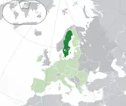
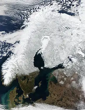
Sweden is a country in Northern Europe on the Scandinavian Peninsula. It borders Norway to the west; Finland to the northeast; and the Baltic Sea and Gulf of Bothnia to the south and east. At 450,295 km2 (173,860 sq mi), Sweden is the largest country in Northern Europe, the fifth largest in Europe, and the 55th largest country in the world.
 | |
| Continent | Europe |
|---|---|
| Region | Scandinavia |
| Coordinates | 62°00′N 15°00′E |
| Area | Ranked 55th |
| • Total | 450,295 km2 (173,860 sq mi) |
| • Land | 91.31% |
| • Water | 8.69% |
| Coastline | 3,218 km (2,000 mi) |
| Borders | Norway 1,666 km (1,035 mi) Finland 545 km (339 mi) |
| Highest point | Kebnekaise 2,097 m (6,880 ft) |
| Lowest point | Kristianstad −2.41 m (−7.9 ft) |
| Longest river | Klarälven-Göta älv 720 km (450 mi) |
| Largest lake | Vänern 5,648 km2 (2,181 sq mi) |
| Climate | Temperate to subarctic |
| Terrain | Flat lowlands, mountains |
| Natural Resources | Iron, copper, lead, zinc, gold, silver, tungsten, uranium, arsenic, feldspar, timber, hydropower |
| Natural Hazards | Ice floe |
| Environmental Issues | Acid rains, eutrophication |
| Exclusive economic zone | 160,885 km2 (62,118 sq mi) |
Sweden has a 3,218 km (2,000 mi) long coastline on its east, and the Scandinavian mountain chain (Scanderna) on its western border, separating it from Norway. It has maritime borders with Denmark, Germany, Poland, Russia, Lithuania, Latvia and Estonia, and it is also linked to Denmark (southwest) by the Öresund bridge. It has an Exclusive Economic Zone of 160,885 km2 (62,118 sq mi).
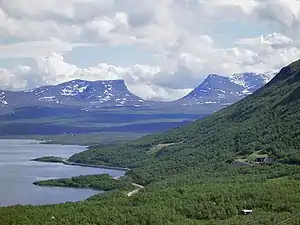
Terrain
.png.webp)
Much of Sweden is heavily forested, with 69%[1] of the country being forest and woodland, while farmland constitutes only 8% of land use.[2] Sweden consists of 39,960 km2 of water area, constituting around 95,700 lakes.[3][upper-alpha 1] The lakes are sometimes used for water power plants, especially the large northern rivers and lakes.
Most of northern and western central Sweden consists of vast tracts of hilly and mountainous land called the Norrland terrain.[5] From the south the transition to the Norrland terrain is not only seen in the relief but also in the wide and contiguous boreal forests that extend north of it[6] with till and peat being the overwhelmingly most common soil types.[7]
South of the Norrland terrain lies the Central Swedish lowland which forms a broad east-west trending belt from Gothenburg to Stockholm.[8][9] This is the traditional heartland of Sweden due to its large population and agricultural resources.[9] The region forms a belt of fertile soils suitable for agriculture that interrupts the forested and till-coated lands to the north and south.[10] Before the expansion of agriculture, these fertile soils were covered by a broad-leaved tree forest where maples, oaks, ashes, small-leaved lime and common hazel grew. The Central Swedish lowland does however also contain soils of poor quality, particularly in hills where Scots pine and Norway spruce grow on top of thin till soils.[10] Agriculture aside, the region benefits also from the proximity of hydropower, forest and bergslagen's mineral resources.[9] Sweden's four largest lakes, Vänern, Vättern, Mälaren and Hjälmaren, lie within the lowlands.[10]
To the south of the Central Swedish lowland lies the South Swedish highlands[8] which except for a lack of deep valleys is similar to the Norrland terrain found further north in Sweden.[7] The highest point of the highlands lies at 377 m.[11] Poor soil conditions have posed significant difficulties for agriculture in the highlands, meaning that over time small industries became relatively important in local economies.[12]
Southernmost Sweden contains a varied landscape with both plains and hilly terrain. A characteristic chain of elongated hills runs across Scania from northwest to southeast. These hills are horsts located along the Tornquist Zone.[13][14] Some of the horsts are Hallandsåsen, Römelåsen and Söderåsen.[13] The plains of Scania and Halland make up 10% of Sweden's cultivated lands and are the country's main agricultural landscape. Productivity is high relative to the rest of Sweden and more akin to that of more southern European countries.[15] The natural vegetation is made up of broadleaf forest although conifer plantations are common. Southern Sweden has Sweden's greatest animal and plant diversity.[16][17]
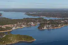
The two largest islands are Gotland and Öland in the southeast. They differ from the rest of Sweden by being made up of limestone and marl with an alvar vegetation adapted to the island's calcareous soils.[18][19] Gotland and Öland have landforms that are rare or absent in mainland Sweden. These include active cliffs seen in segments of their western coasts,[20] sea stacks called rauks and large cave systems.
Political divisions
Provinces
Sweden has 25 provinces or landskap ("landscapes"), based on culture, geography and history: Bohuslän, Blekinge, Dalarna, Dalsland, Gotland, Gästrikland, Halland, Hälsingland, Härjedalen, Jämtland, Lapland, Medelpad, Norrbotten, Närke, Skåne, Småland, Södermanland, Uppland, Värmland, Västmanland, Västerbotten, Västergötland, Ångermanland, Öland and Östergötland.
While these provinces serve no political or administrative purpose, they play an important role for people's self-identification. The provinces are usually grouped together in three large lands (landsdelar): the northern Norrland, the central Svealand and southern Götaland. The sparsely populated Norrland encompasses almost 60% of the country.
Counties
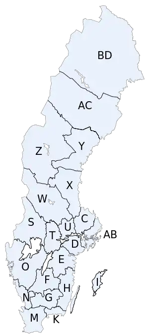
Administratively, Sweden is divided into 21 counties, or län. In each county there is a County Administrative Board, or länsstyrelse, which is appointed by the national government.
In each county there is also a separate County Council, or landsting, which is the municipal representation appointed by the county electorate.
- K = Blekinge County
- W = Dalarna County
- I = Gotland County
- X = Gävleborg County
- N = Halland County
- Z = Jämtland County
- F = Jönköping County
- H = Kalmar County
- G = Kronoberg County
- BD = Norrbotten County
- M = Skåne County
- AB = Stockholm County
- D = Södermanland County
- C = Uppsala County
- S = Värmland County
- AC = Västerbotten County
- Y = Västernorrland County
- U = Västmanland County
- O = Västra Götaland County
- T = Örebro County
- E = Östergötland County
The letters shown were on the vehicle registration plates until 1973.
Municipalities
Each county is further divided into municipalities or kommuner, ranging from only one (in Gotland County) to forty-nine (in Västra Götaland County). The total number of municipalities is 290.
The northern municipalities are often large in size, but have small populations – the largest municipality is Kiruna with an area as large as the three southern provinces in Sweden (Scania, Blekinge and Halland) combined, but it only has a population of 25,000, and its density is about 1 / km2.
people/km2
Population
Sweden has a population of 10 million as of January 2017.[21] The mountainous north is considerably less populated than the southern and central regions, partly because the summer period lasts longer in the south, and this is where the more successful agricultural industries were originally established. Another historical reason is said to be the desired proximity to key trade routes and partners in continental Europe, e.g. Germany. As a result, all seven urban areas in Sweden with a population of 100,000 or more, are located in the southern half of the country.[22]
Cities
Cities and towns in Sweden are neither political nor administrative entities; rather they are localities or urban areas, independent of municipal subdivisions. The largest city, in terms of population, is the capital Stockholm, in the east, the dominant city for culture and media, with a population of 1,250,000. The second largest city is Gothenburg, with 510,500, in the west. The third largest is Malmö in the south, with 258,000. The largest city in the north is Umeå with 76,000 inhabitants.
Natural resources
Sweden's natural resources include copper, gold, hydropower, iron ore, lead, silver, timber, uranium, and zinc.
Environment
Acid rain has become an issue because it is damaging soils and lakes and polluting the North Sea and the Baltic Sea. The HBV hydrology transport model has been used to analyze nutrient discharge to the Baltic from tributary watersheds.
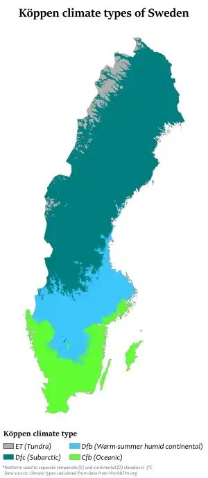
Climate
| Gothenburg | ||||||||||||||||||||||||||||||||||||||||||||||||||||||||||||
|---|---|---|---|---|---|---|---|---|---|---|---|---|---|---|---|---|---|---|---|---|---|---|---|---|---|---|---|---|---|---|---|---|---|---|---|---|---|---|---|---|---|---|---|---|---|---|---|---|---|---|---|---|---|---|---|---|---|---|---|---|
| Climate chart (explanation) | ||||||||||||||||||||||||||||||||||||||||||||||||||||||||||||
| ||||||||||||||||||||||||||||||||||||||||||||||||||||||||||||
| ||||||||||||||||||||||||||||||||||||||||||||||||||||||||||||
| Kiruna | ||||||||||||||||||||||||||||||||||||||||||||||||||||||||||||
|---|---|---|---|---|---|---|---|---|---|---|---|---|---|---|---|---|---|---|---|---|---|---|---|---|---|---|---|---|---|---|---|---|---|---|---|---|---|---|---|---|---|---|---|---|---|---|---|---|---|---|---|---|---|---|---|---|---|---|---|---|
| Climate chart (explanation) | ||||||||||||||||||||||||||||||||||||||||||||||||||||||||||||
| ||||||||||||||||||||||||||||||||||||||||||||||||||||||||||||
| ||||||||||||||||||||||||||||||||||||||||||||||||||||||||||||
| Nyköping | ||||||||||||||||||||||||||||||||||||||||||||||||||||||||||||
|---|---|---|---|---|---|---|---|---|---|---|---|---|---|---|---|---|---|---|---|---|---|---|---|---|---|---|---|---|---|---|---|---|---|---|---|---|---|---|---|---|---|---|---|---|---|---|---|---|---|---|---|---|---|---|---|---|---|---|---|---|
| Climate chart (explanation) | ||||||||||||||||||||||||||||||||||||||||||||||||||||||||||||
| ||||||||||||||||||||||||||||||||||||||||||||||||||||||||||||
| ||||||||||||||||||||||||||||||||||||||||||||||||||||||||||||
| Stockholm | ||||||||||||||||||||||||||||||||||||||||||||||||||||||||||||
|---|---|---|---|---|---|---|---|---|---|---|---|---|---|---|---|---|---|---|---|---|---|---|---|---|---|---|---|---|---|---|---|---|---|---|---|---|---|---|---|---|---|---|---|---|---|---|---|---|---|---|---|---|---|---|---|---|---|---|---|---|
| Climate chart (explanation) | ||||||||||||||||||||||||||||||||||||||||||||||||||||||||||||
| ||||||||||||||||||||||||||||||||||||||||||||||||||||||||||||
| ||||||||||||||||||||||||||||||||||||||||||||||||||||||||||||
Swedish Meteorological Institute, SMHI's monthly average temperatures of some of their weather stations – for the latest scientific full prefixed thirty-year period 1961–1990 Next will be presented in year 2020. The weather stations are sorted from south towards north by their numbers.
| stn.nr. | station | Jan | Feb | Mar | Apr | May | Jun | Jul | Aug | Sep | Oct | Nov | Dec | Annual |
|---|---|---|---|---|---|---|---|---|---|---|---|---|---|---|
| 5337 | Malmö | 0.1 | 0.0 | 2.2 | 6.4 | 11.6 | 15.8 | 17.1 | 16.8 | 13.6 | 9.8 | 5.3 | 1.9 | 8.4 |
| 6203 | Helsingborg | 0.6 | −0.1 | 2.0 | 6.0 | 11.2 | 15.3 | 16.7 | 16.6 | 13.6 | 9.9 | 5.2 | 1.8 | 8.3 |
| 6451 | Växjö | −2.8 | −2.8 | 0.0 | 4.7 | 10.2 | 14.3 | 15.3 | 14.9 | 11.2 | 7.0 | 2.3 | −1.2 | 6.1 |
| 7839 | Visby | −0.5 | −1.2 | 0.7 | 4.1 | 9.5 | 14.0 | 16.4 | 16.0 | 12.5 | 8.6 | 4.3 | 1.2 | 7.1 |
| 7447 | Jönköping | −2.6 | −2.7 | 0.3 | 4.7 | 10.0 | 14.5 | 15.9 | 15.0 | 11.3 | 7.5 | 2.8 | −0.7 | 6.3 |
| 7263 | Göteborg | −0.9 | −0.9 | 2.0 | 6.0 | 11.6 | 15.5 | 16.6 | 16.2 | 12.8 | 9.1 | 4.4 | 1.0 | 7.8 |
| 8323 | Skövde | −2.8 | −2.9 | 0.0 | 4.6 | 10.6 | 15.0 | 16.2 | 15.2 | 11.1 | 7.1 | 2.2 | −1.1 | 6.3 |
| 8634 | Norrköping | −3.0 | −3.2 | 0.0 | 4.5 | 10.4 | 15.1 | 16.6 | 15.5 | 11.3 | 7.2 | 2.2 | −1.4 | 6.3 |
| 9516 | Örebro | −4.0 | −4.0 | −0.5 | 4.3 | 10.7 | 15.3 | 16.5 | 15.3 | 10.9 | 6.6 | 1.3 | −2.4 | 5.8 |
| 9720 | Stockholm Bromma | −3.5 | −3.7 | −0.5 | 4.3 | 10.4 | 15.2 | 16.8 | 15.8 | 11.4 | 7.0 | 2.0 | −1.8 | 6.1 |
| 9739 | Stockholm Arlanda | −4.3 | −4.6 | −1.0 | 3.9 | 9.9 | 14.8 | 16.5 | 15.2 | 10.7 | 6.4 | 1.2 | −2.6 | 5.5 |
| 10458 | Mora | −7.4 | −7.2 | −2.4 | 2.5 | 9.1 | 14.1 | 15.4 | 13.5 | 9.3 | 4.9 | −1.6 | −6.1 | 3.7 |
| 10740 | Gävle | −4.8 | −4.5 | −1.0 | 3.4 | 9.3 | 14.6 | 16.3 | 14.9 | 10.6 | 6.0 | 0.6 | −3.3 | 5.2 |
| 12724 | Sundsvall | −7.5 | −6.3 | −2.3 | 2.5 | 8.2 | 13.8 | 15.2 | 13.8 | 9.4 | 4.8 | −1.5 | −5.7 | 3.6 |
| 13410 | Östersund | −8.9 | −7.6 | −3.5 | 1.3 | 7.6 | 12.5 | 13.9 | 12.7 | 8.2 | 3.8 | −2.4 | −6.3 | 2.6 |
| 14050 | Umeå | −8.7 | −8.3 | −4.0 | 1.4 | 7.6 | 13.3 | 15.6 | 13.8 | 9.0 | 4.0 | −2.3 | −6.4 | 2.9 |
| 15045 | Skellefteå | −10.2 | −8.7 | −4.2 | 1.2 | 7.6 | 13.6 | 15.7 | 13.5 | 8.5 | 3.2 | −3.4 | −7.5 | 2.5 |
| 16288 | Luleå | −12.2 | −11.0 | −6.0 | 0.3 | 6.6 | 13.0 | 15.4 | 13.3 | 8.0 | 2.6 | −4.5 | −9.7 | 1.3 |
| 16395 | Haparanda | −12.1 | −11.4 | −6.8 | −0.5 | 6.1 | 12.8 | 15.4 | 13.2 | 8.0 | 2.5 | −4.2 | −9.5 | 1.1 |
| 16988 | Jokkmokk | −17.5 | −14.9 | −8.6 | −1.1 | 5.9 | 12.2 | 14.3 | 11.8 | 5.7 | −0.2 | −9.3 | −14.6 | -1.4 |
| 17897 | Tarfala (a mountain peak) | −11.8 | −11.3 | −10.6 | −7.5 | −1.9 | 3.2 | 6.4 | 5.3 | 0.8 | −3.9 | −7.9 | −10.7 | -4.2 |
| 18076 | Gällivare | −14.3 | −12.5 | −8.4 | −1.9 | 5.0 | 11.0 | 13.0 | 10.7 | 5.6 | −0.6 | −8.1 | −12.2 | -1.1 |
| 18094 | Kiruna | −13.9 | −12.5 | −8.7 | −3.2 | 3.4 | 9.6 | 12.0 | 9.8 | 4.6 | −1.4 | −8.1 | −11.9 | -1.7 |
Extremes
| Climate data for Sweden | |||||||||||||
|---|---|---|---|---|---|---|---|---|---|---|---|---|---|
| Month | Jan | Feb | Mar | Apr | May | Jun | Jul | Aug | Sep | Oct | Nov | Dec | Year |
| Record high °C (°F) | 11.0 (51.8) |
16.2 (61.2) |
20.9 (69.6) |
28.8 (83.8) |
32.8 (91.0) |
38.0 (100.4) |
38.0 (100.4) |
36.2 (97.2) |
28.3 (82.9) |
23.2 (73.8) |
16.5 (61.7) |
13.2 (55.8) |
38.0 (100.4) |
| Record low °C (°F) | −49.4 (−56.9) |
−52.6 (−62.7) |
−45.8 (−50.4) |
−36.5 (−33.7) |
−22.2 (−8.0) |
−5.5 (22.1) |
−4.0 (24.8) |
−8.5 (16.7) |
−13.1 (8.4) |
−30 (−22) |
−39.0 (−38.2) |
−48.9 (−56.0) |
−52.6 (−62.7) |
Extreme points
The extreme points of Sweden include the coordinates that are farthest north, south, east and west in Sweden, and the ones that are at the highest and the lowest elevations in the country. Unlike Norway and Denmark, Sweden has no external territories that can be considered either inside or outside the country depending on definition, meaning that the extreme points of Sweden are unambiguous.
The latitude and longitude are expressed in decimal degree notation, in which a positive latitude value refers to the Northern Hemisphere, and a negative value refers to the Southern Hemisphere. Additionally, a negative elevation value refers to land below sea level. The coordinates used in this article are sourced from Google Earth, which makes use of the World Geodetic System (WGS) 84, a geodetic reference system.
Latitude and longitude
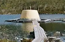
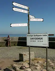
Sweden's northernmost point is Treriksröset, in the Lapland province,[28] where the borders of Sweden, Norway, and Finland meet. The closest Swedish city to the area is Kiruna, which is Sweden's northernmost city.[29] Sweden's southernmost point is in the harbour of the fishing village Smygehuk, near the city of Trelleborg,[30] which borders the Baltic Sea.[31] At the pier of the harbour, a signpost displays the exact position of the point, as well as the distance to Treriksröset, Stockholm, Berlin, Paris, and Moscow.[30]
Sweden's westernmost point is on Stora Drammen, an islet in Skagerrak outside the coast of Bohuslän.[32] Seabirds and harbor seals have colonies on the islet, but it is uninhabited by humans.[33] Sweden's easternmost point is on Kataja,[32] an islet south of Haparanda in the Bothnian Bay.[34] The islet is divided between Sweden and Finland. The border was established in 1809, after the Finnish War, between what was previously two islets, a Swedish one called Kataja and a smaller Finnish one called Inakari. Since 1809, post-glacial rebound has caused the sea level in the region to drop relative to land level, joining the two islets.[35] If counting the mainland only, Stensvik in Strömstad is Sweden's westernmost point,[36] and Sundholmen in Haparanda is the easternmost point.[37]
| Heading | Location | Province | Bordering entity | Coordinates[38] | Ref |
|---|---|---|---|---|---|
| North | Treriksröset, Kiruna | Lapland | Troms, Norway, and Lapland, Finland | 69.06°N 20.548611°E | [29][32][39] |
| South | Smygehuk, Trelleborg | Scania | Baltic Sea | 55.336944°N 13.359444°E | [31][32][40] |
| West | Stora Drammen, Strömstad | Bohuslän | Skagerrak | 58.928611°N 10.9575°E | [32][41][42] |
| West (mainland) | Stensvik, Strömstad | Bohuslän | Skagerrak | 58.997222°N 11.113056°E | [36][43][44] |
| East | Finnish border on north coast of Kataja, Haparanda | Norrbotten | Bothnian Bay | 65.710833°N 24.155833°E | [32][45][46] |
| East (mainland) | Sundholmen, Haparanda | Norrbotten | Torne River, and the Bothnian Bay | 65.815°N 24.150556°E | [37][39][47] |
Elevation
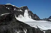
The highest point in Sweden is Kebnekaise, which stands at 2,097 metres (6,880 ft) (August 2018). It is in the Scandinavian Mountains chain, in the province of Lapland.[48][49] The mountain has two peaks, of which the glaciated southern one is the highest at 2,097 metres (6,880 ft).[48] The northern peak, which stands at 2,096 metres (6,877 ft), is free of ice. Although the south top is traditionally said to be 2,097 metres (6,880 ft) high,[28] new measurements have shown that the glacier has shrunk fairly fast; therefore the summit is not as high as earlier. It was 2,104 metres (6,903 ft) in 2008.[48] Other points of comparable height in the vicinity of Kebnekaise include Sarektjåkka at 2,089 metres (6,854 ft), and Kaskasatjåkka at 2,076 metres (6,811 ft).[32] If the summers of 2016 and 2017 get as warm as the previous years, the northern peak will become the highest.[50]
Sweden's lowest point, which is 2.41 metres (7.91 ft) below sea level, is in the Kristianstads Vattenrike Biosphere Reserve in the city of Kristianstad.[28] The point is at the bottom of what was once Nosabyviken, a bay on the lake of Hammarsjön. The bay was drained in the 1860s by John Nun Milner, an engineer, to get more arable land for Kristianstad.[51]
| Extremity | Name | Elevation | Location | Province | Coordinates[38] | Ref |
|---|---|---|---|---|---|---|
| Highest | Kebnekaise | 2,097 metres (6,880 ft) | Scandinavian Mountains | Lapland | 67.9°N 18.516667°E | [48][49][52] |
| Lowest | Kristianstads Vattenrike Biosphere Reserve | −2.41 metres (−7.91 ft) | Kristianstad | Scania (Skåne) | 56.021581°N 14.178878°E | [28][34][51] |
| Deepest lake (from its surface) | Hornavan | 221 metres (725 ft) | Arjeplog | Norrbotten |
Transportation
Only public transportation.
| Heading | Airport | Railway station | Bus stop |
|---|---|---|---|
| North | Kiruna | Vassijaure (68.4290934°N 18.2606904°E) | Karesuando bus station (68.441474°N 22.4791197°E) |
| South | Malmö | Trelleborg (55.371783°N 13.159206°E | Smygehuk Hamnen (55.339544°N 13.359984°E) |
| West | Göteborg | Strömstad (58.936509°N 11.173283°E) | Strömstad Color Line terminal (58.934442°N 11.170618°E) |
| East | Pajala | Luleå (65°35′2″N 22°9′55″E) | Haparanda-Tornio bus station (65°50′36″N 24°8′18″E) |
| Highest | Sälen, 490 m (1,610 ft) | Storlien, 592 m (1,942 ft) (63°18′57″N 12°6′2″E) |
See also
Notes
- The great number of lakes in southern Sweden could according to Alfred Gabriel Nathorst be indebted to the creation of basins due to the stripping of an irregular mantle of weathered rock by glacier erosion.[4]
References
- "Swedes love nature". sweden.se. 2014-08-20. Retrieved 2014-08-26.
- "Land use in Sweden 2010". Statistiska Centralbyrån (in Swedish). Retrieved 2018-02-09.
- Archived June 19, 2009, at the Wayback Machine
- Lidmar-Bergström, K.; Olsson, S.; Roaldset, E. (1999). "Relief features and palaeoweathering remnants in formerly glaciated Scandinavian basement areas". In Thiry, Médard; Simon-Coinçon, Régine (eds.). Palaeoweathering, Palaeosurfaces and Related Continental Deposits. Special publication of the International Association of Sedimentologists. 27. Blackwell Science Ltd. pp. 275–301. ISBN 0-632-05311-9.
- De Geer, Sten (1926). "Norra Sveriges landforms-regioner". Geografiska Annaler (in Swedish). Swedish Society for Anthropology and Geography. 8: 125–136.
- Sporrong, Ulf (2003). "The Scandinavian landscape and its resources". In Helle, Knut (ed.). The Cambridge History of Scandinavia. Cambridge University Press. pp. 22.
- Lundqvist, Magnus; Lundqvist, Jan; Rystedt, Gunnar; Malmer, Nils; Ulfstrand, Staffan; Behrens, Sven; Fries, Jöran; Larsson, Erik; Segnestam, Mats; Landell, Nils-Erik; Persson, Göran; Rosén, Bo (1969). "Landskapet". Det Moderna Sverige (in Swedish). Bonniers. pp. 64–67.
- "Mellansvenska sänkan - Uppslagsverk - NE.se". www.ne.se. Retrieved 10 April 2018.
- Hobbs, Joseph J., ed. (2009). "Northern Europe: Prosperous, wild and wired". World Regional Geography (6th ed.). p. 127.
- Andersson, Gunnar (1915). "Ytbildning". In Guinchard, Joseph (ed.). Sveriges land och folk: historisk-statistisk handbok (in Swedish). pp. 13–14.
- Lidmar-Bergström, Karna; Bonow, Johan M.; Japsen, Peter (2013). "Stratigraphic Landscape Analysis and geomorphological paradigms: Scandinavia as an example of Phanerözoic uplift and subsidence". Global and Planetary Change. 100: 153–171. Bibcode:2013GPC...100..153L. doi:10.1016/j.gloplacha.2012.10.015.
- "Kulturspår på sydsvenska höglandet". Skogskunskap (in Swedish). November 6, 2016. Retrieved May 10, 2019.
- Behrens, Sven. "Skåne: Terrängformer". Nationalencyklopedin (in Swedish). Cydonia Development. Retrieved November 30, 2017.
- Ahlberg, Per. "Skåne: Berggrund". Nationalencyklopedin (in Swedish). Cydonia Development. Retrieved November 30, 2017.
- Granström, Birger. "Produktionsområden". Nationalencyklopedin (in Swedish). Cydonia Development. Retrieved November 30, 2017.
- Olsson, Olle G.; Karlsson, Thomas. "Skåne: Växtliv". Nationalencyklopedin (in Swedish). Cydonia Development. Retrieved November 30, 2017.
- "Skåne: Djurliv". Nationalencyklopedin (in Swedish). Cydonia Development. Retrieved November 30, 2017.
- Behrens, Sven. "Gotland: Terrängformer". Nationalencyklopedin (in Swedish). Cydonia Development. Retrieved November 30, 2017.
- Ott, S.; Elders, U.; Jahns, H.M. (1996). "Vegetation of the rock-alvar of Gotland. I. Microhabitats and succession". Nova Hedwigia. 63 (3): 433–470. Retrieved November 25, 2017.
- Rudberg, Sten (1967). "The cliff coast of Gotland and the rate of cliff retreat". Geografiska Annaler. 49 (2): 283–298. doi:10.2307/520895. JSTOR 520895.
- Radio, Sveriges. "Swedish population hits 10-million mark - Radio Sweden". sverigesradio.se. Retrieved 10 April 2018.
- "Varannan svensk bor nära havet". scb.se. Retrieved 10 April 2018.
- "Climate Gothenburg - Västra Götaland". Climatedata.eu. Retrieved 2014-08-26.
- "Temperatur | SMHI" (in Swedish). FIXME: Smhi.se. Retrieved 2014-08-26.
- "Climatological Normals of Stockholm". Hko.gov.hk. 2012-12-20. Retrieved 2014-08-26.
- The weather stations' names and numbers are first found at "Archived copy" (PDF). Archived (PDF) from the original on 3 March 2016. Retrieved 12 May 2015.CS1 maint: archived copy as title (link)
- "Average Temperatures for each Months and Annual Average". Archived from the original on 9 October 2013.
- "Sweden: Geography". CIA – The World Factbook. Retrieved 2008-10-28.
- "Google Maps (Treriksröset)". Google. Retrieved 2008-10-28.
- "Trelleborgs kommun - Smygehuk" (in Swedish). Trelleborg.se. May 15, 2003. Retrieved 2008-10-28.
- "Google Maps (Smygehuk)". Google. Retrieved 2008-10-28.
- "Geografiska uppgifter (Geographical data)" (PDF) (in Swedish and English). Statistics Sweden. Retrieved 2008-10-28.
- "Reportage - Stora Drammen" (in Swedish). Sweden Offroad Tour. Archived from the original on February 9, 2005. Retrieved 2008-10-28.
- "Svenskt ortnamnsregister" (in Swedish). Sverigeatlas.se. Archived from the original on 2013-04-18. Retrieved 2008-10-28.
- Tingbrand, Per (1984). Kataja - Sveriges östligaste skär. Västkustrapsodi (in Swedish). Borås: Svenska Kryssarklubben.
- "Eniro Maps (Stensvik)". Eniro (in Swedish). Retrieved 2008-10-29.
- "Sundholmen är ett internationellt centrum i Bottenviksbågen och Barentsområdet" (in Swedish). Haparanda.se. Archived from the original on May 3, 2008. Retrieved Mar 3, 2008.
- Coordinates obtained from Google Earth. Google Earth makes use of the WGS84 geodetic reference system.
- Almqvist & Wiksells stor-atlas, p. 4
- Almqvist & Wiksells stor-atlas, p. 7
- "Google Maps (Stora Drammen)". Google. Retrieved 2008-10-11.
- "Eniro Maps (Stora Drammen)". Eniro (in Swedish). Retrieved 2008-10-29.
- Almqvist & Wiksells stor-atlas, p. 6
- "Förutsättningar, analys och överväganden" (PDF) (in Swedish). Strömstad.se. Archived from the original (PDF) on 2009-02-25. Retrieved 2008-10-29.
- "Google Maps (Kataja)". Google. Retrieved 2008-10-29.
- "Eniro Maps (Kataja)". Eniro (in Swedish). Retrieved 2008-10-29.
- "Google Maps (Sundholmen)". Google. Retrieved 2008-10-29.
- Annika, Rydman (August 18, 2008). "Sydtoppen fortfarande högst i Sverige" (in Swedish). Dagens Nyheter. Archived from the original on May 14, 2011. Retrieved 2008-10-27.
- "Google Maps (Kebnekaise)". Google. Retrieved 2008-10-11.
- "Sweden's highest point set to lose title as glacier melts". The Guardian. 1 August 2018. Retrieved 1 August 2018.
- "Lägsta punkten (Lowest point)" (in Swedish). Kristianstad.se. Archived from the original on March 6, 2008. Retrieved Mar 6, 2008.
- Almqvist & Wiksells stor-atlas, p. 18
- Almqvist & Wiksells stor-atlas (in Swedish). Stockholm: Liber AB. November 2003. ISBN 91-21-20680-5. OCLC 243941349.