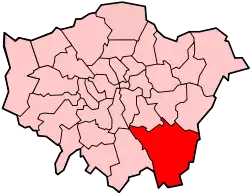
Grade I and II* listed buildings in the London Borough of Bromley
There are over 9,000 Grade I listed buildings and 20,000 Grade II* listed buildings in England. This page is a list of these buildings in the London Borough of Bromley.
Grade I
| Name | Location | Type | Completed [note 1] | Date designated | Grid ref.[note 2] Geo-coordinates |
Entry number [note 3] | Image |
|---|---|---|---|---|---|---|---|
| Bromley College | Bromley | House | 1666 | 10 January 1955 | TQ4002269573 51°24′28″N 0°00′43″E |
1359324 | |
| Gateway at Bromley College | Bromley | Gate | 1665 | 10 January 1955 | TQ3999769565 51°24′28″N 0°00′41″E |
1064374 |  |
| Down House | Downe | House | Early 19th century | 31 May 1954 | TQ4315461150 51°19′53″N 0°03′12″E |
1038325 | |
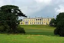
| Holwood House | Keston | Country house | 1825 | 10 January 1955 | TQ4224263549 51°21′12″N 0°02′29″E |
1281097 | |
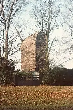
| Keston Windmill | Keston | Windmill | 1716 | 10 January 1955 | TQ4154564028 51°21′28″N 0°01′53″E |
1064369 | |
| Prehistoric animal sculptures, geological formations and lead mine on Islands and on land facing the Lower Lake | Penge/Beckenham | Statue | 1852–55 | 29 June 1973 | TQ3448770522 51°25′04″N 0°04′02″W |
1067798 |  Prehistoric animal sculptures, geological formations and lead mine on Islands and on land facing the Lower Lake |
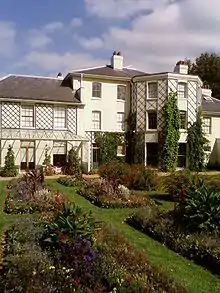
| Sundridge Park | Bromley | Country house | Early 18th century | 10 January 1955 | TQ4179170634 51°25′01″N 0°02′16″E |
1299044 | |
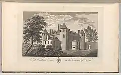
| Wickham Court | Beckenham | Courtyard house | Reign of Edward IV | 28 May 1954 | TQ3899164756 51°21′54″N 0°00′18″W |
1055809 |

Grade II*
| Name | Location | Type | Completed [note 1] | Date designated | Grid ref.[note 2] Geo-coordinates |
Entry number [note 3] | Image |
|---|---|---|---|---|---|---|---|
| Bromley War Memorial, St Martin's Hill | Bromley | War memorial | 1922 | 14 December 1995 | TQ3997969238 51°24′18″N 0°00′40″E |
1116976 | 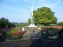 Bromley War Memorial, St Martin's Hill |
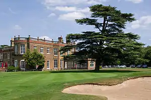
| Bullers Wood | Chislehurst | House | 1889 | 29 June 1973 | TQ4243469770 51°24′33″N 0°02′48″E |
1204400 | |
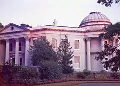
| Camden Place | Chislehurst | House | 1609–23 | 25 August 1954 | TQ4374170042 51°24′40″N 0°03′56″E |
1064325 | |
| Chesil House | Chislehurst | House | 18th century | 25 August 1954 | TQ4458669981 51°24′38″N 0°04′39″E |
1299045 | 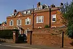 Chesil House |
| Church of All Saints | Orpington | Church | 14th century | 31 May 1954 | TQ4666166413 51°22′40″N 0°06′21″E |
1083559 |  Church of All Saints |
| Church of St Giles the Abbot | Farnborough, Bromley | Church | 1640 | 31 May 1954 | TQ4438164125 51°21′28″N 0°04′20″E |
1064339 |  Church of St Giles the Abbot |
| Church of St John the Baptist | West Wickham | Church | Late 15th century | 28 May 1954 | TQ3889864854 51°21′57″N 0°00′22″W |
1359332 | 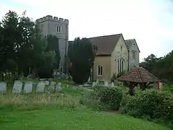 Church of St John the Baptist |
| Lych-gate to Church of St John the Baptist's Churchyard | West Wickham | Lych gate | 15th century or early 16th century | 28 May 1954 | TQ3893964849 51°21′57″N 0°00′20″W |
1064391 | 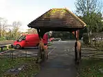 Lych-gate to Church of St John the Baptist's Churchyard |
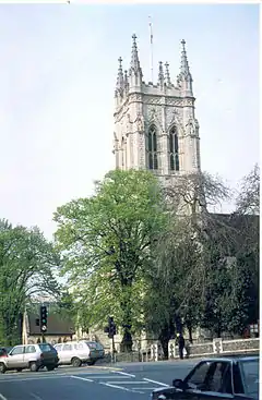
| Church of St Martin of Tours | Bromley | Church | 1857 | 31 May 1954 | TQ4796064002 51°21′21″N 0°07′25″E |
1084343 | 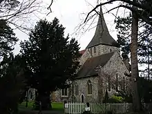 Church of St Martin of Tours |
| Church of St Mary | Orpington | Church | Early 13th century | 31 May 1954 | TQ4722368367 51°23′43″N 0°06′53″E |
1045813 |  Church of St Mary |
| Church of St Mary the Virgin | Downe | Church | 13th century | 31 May 1954 | TQ4320761650 51°20′09″N 0°03′16″E |
1359316 | |
| Church of St Nicholas | Chislehurst | Church | c.1460 | 25 August 1954 | TQ4441769919 51°24′36″N 0°04′30″E |
1064345 | 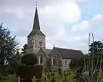 Church of St Nicholas |
| Church of St Paulinus | St Paul's Cray | Church | Late 12th century or early 13th century | 25 August 1954 | TQ4739369086 51°24′06″N 0°07′03″E |
1064396 |  Church of St Paulinus |
| Church of St Peter and St Paul | Bromley | Church | 1855 | 10 January 1955 | TQ4012169245 51°24′18″N 0°00′47″E |
1084373 | |
| Church of St Peter and St Paul | Cudham | Church | Anglo Saxon origins | 31 May 1954 | TQ4449759952 51°19′13″N 0°04′20″E |
1359355 | 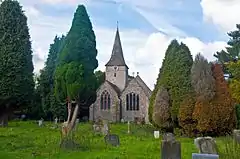 Church of St Peter and St Paul |
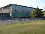
| Crystal Palace National Sports Centre | Bromley | Sports centre | 1960–64 | 2 December 1997 | TQ3447570894 51°25′16″N 0°04′03″W |
1031539 | |
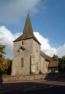
| Keston Parish Church | Keston | Church | 12th-century origin | 10 January 1955 | TQ4184163002 51°20′54″N 0°02′07″E |
1064343 | 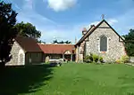 Keston Parish Church |
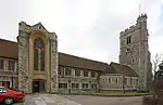
| Kevington County Primary School [now Kevington Hall] | Orpington | Country house | Late 18th century | 31 May 1954 | TQ4793967640 51°23′19″N 0°07′29″E)] |
1359374 | 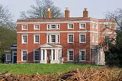 Kevington County Primary School [now Kevington Hall] |
| Parish Church of St George | Beckenham | Church | 1902–03 | 28 May 1954 | TQ3747769644 51°24′33″N 0°01′29″W |
1054025 | |
| Parish Church the Annunciation of Blessed Virgin Mary | Chislehurst | Church | 1868–70 | 29 June 1973 | TQ4383970931 51°25′09″N 0°04′02″E |
1359325 | 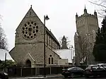 Parish Church the Annunciation of Blessed Virgin Mary |
| Quernmore Secondary School | Bromley | House | About 1777 | 10 January 1955 | TQ4019270453 51°24′57″N 0°00′53″E |
1055761 | |
| Orpington Priory | Orpington | House | 15th century | 31 May 1954 | TQ4657766533 51°22′44″N 0°06′17″E |
1064330 |

Notes
- The date given is the date used by Historic England as significant for the initial building or that of an important part in the structure's description.
- Sometimes known as OSGB36, the grid reference is based on the British national grid reference system used by the Ordnance Survey.
- The "List Entry Number" is a unique number assigned to each listed building and scheduled monument by Historic England.
External links
 Media related to Grade I listed buildings in the London Borough of Bromley at Wikimedia Commons
- Media related to Grade II* listed buildings in the London Borough of Bromley at Wikimedia Commons
This article is issued from Wikipedia. The text is licensed under Creative Commons - Attribution - Sharealike. Additional terms may apply for the media files.