Penge
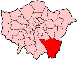
Penge is an area of South East London, England, within the London Borough of Bromley. It is located 3.5 miles west of Bromley, 3.7 miles north east of Croydon and 7.1 miles south east of Charing Cross, the traditional centre of London.
| Penge | |
|---|---|
 Congregational Church, Penge | |
 Penge Location within Greater London | |
| OS grid reference | TQ345705 |
| • Charing Cross | 7.1 mi (11.4 km) NNW |
| London borough | |
| Ceremonial county | Greater London |
| Region | |
| Country | England |
| Sovereign state | United Kingdom |
| Post town | LONDON |
| Postcode district | SE20 |
| Dialling code | 020 |
| Police | Metropolitan |
| Fire | London |
| Ambulance | London |
| UK Parliament | |
| London Assembly | |
History
Penge was once a small town, which was recorded under the name Penceat in an Anglo-Saxon deed dating from 957. Most historians believe the name of the town is derived from the Celtic word Penceat, which means 'edge of wood' and refers to the fact that the surrounding area was once covered in a dense forest. The original Celtic words of which the name was composed referred to 'pen' ('head'), as in the Welsh 'pen', and 'ceat' ('wood'), similar to the Welsh 'coed', as in the name of the town of Pencoed in Wales. The largest amosite mine in the world, in South Africa, was named Penge apparently because one of the British directors thought the two areas were similar in appearance.[1]
Pensgreene and the Crooked Billet
Penge was an inconspicuous area with few residents before the arrival of the railways. A traveller passing through Penge would have noticed the large green with a small inn on its boundary. Penge Green appears as Pensgreene on Kip's 1607 map.[2] The green was bounded to the north by Penge Lane, the west by Beckenham Road and the southeast by the Crooked Billet. On a modern map that is a very small area, but the modern-day Penge Lane and Crooked Billet are not in their original locations, and Beckenham Road would have been little more than a cart track following the property line on the west side of Penge High Street. Penge Lane was the road from Penge to Sydenham which is now named St John's Road and Newlands Park Road. There was also an old footpath crossing the Green leading to Sydenham, that was known as Old Penge Lane. After the London, Chatham and Dover Railway was built, Penge Lane crossed the line by level crossing. When this crossing was closed, Penge Lane was renamed and Old Penge Lane became the present-day Penge Lane.
The 1868 Ordnance Survey map shows the Old Crooked Billet located to the southeast of the current location. This earlier location was on the eastward side of Penge Green, which disappeared as a result of the Penge Enclosure Act, 1827 which enclosed the whole Green. This left the Crooked Billet with no frontage to Beckenham Road; hence, new premises were constructed on the present site in 1827, and subsequently replaced in 1840 with a three-storey building. This was severely damaged by enemy action in the Second World War, and subsequently rebuilt.[3]
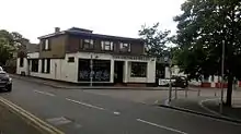
The Crooked Billet (pictured right) is by far the oldest public house in Penge. Peter Abbott[4] states that it was there in 1601, and speculates that it might be much more ancient. In modern times it is particularly well known for lending its name to a bus route terminus. From 1914, General Omnibus routes 109 and 609 operated, along different paths, between Bromley Market and the Crooked Billet. The 109 was renumbered 227 by London Transport, and continued to terminate at the Crooked Billet. (Route 609 was shortened, terminating in Beckenham). Around 1950, some services were extended past the Crooked Billet to Crystal Palace. Eventually nearly all buses travelled the extended route. The 354 buses now use the terminus, as do short-running buses on routes 194 and 358.
William Hone wrote about a visit to the Crooked Billet in 1827[5] and included a detailed sketch of the last building on the original site.
Expansion
The London and Croydon Canal was built across Penge Common along what is now the line of the railway through Penge West railway station, deviating to the south before Anerley railway station. There is a remnant at the northern corner of Betts Park, Anerley.[6] Following the closure of the canal, the London and Croydon Railway was built largely along the same course, opening in 1839. Isambard Kingdom Brunel built an atmospheric railway along this alignment as far as Croydon. The Crystal Palace pneumatic railway, which ran underground between the Sydenham and Penge entrances to Crystal Palace Park, operated for a short while but proved not to be economically viable.
In the Victorian era, Penge developed into a fashionable suburb because of the railway line and its proximity to the relocated Crystal Palace. It became a fashionable day out to visit the Crystal Palace during the day and to take the tram down the hill to one of the 'twenty-five pubs to the square mile'[7] that Penge was reputed to possess, or the two music halls—The King's Hall (later the Gaumont cinema) and, established in 1915, the Empire Theatre (later the Essoldo cinema).[8][9]
By 1862, Stanford's map of London and its Suburbs[10] shows large homes had been constructed along Penge New Road (now Crystal Palace Park Road, Sydenham and Penge High Street), Thick Wood (now Thicket) Road and Anerley Road.[11] This all came to an end in 1875 and 1877, with the notorious Penge murders. In 1875 Frederick Hunt murdered his wife and children,[12] then in 1877 a wealthy heiress, Harriet Staunton, together with her infant son, was starved to death by her husband and his associates.[13] In 1934, Elizabeth Jenkins published the novel Harriet, based on the case,[14] whilst Forbes Road was renamed to Mosslea Road because of its connection with the murders.
Governance
Penge formed a part of the parish of Battersea, with the historic county boundary between Kent and Surrey forming its eastern boundary.[15] In 1855 both parts of the parish were included in the area of the Metropolitan Board of Works, with Penge Hamlet Vestry electing six members to the Lewisham District Board of Works.[16] The Local Government Act 1888 abolished the Metropolitan Board, with its area becoming the County of London. However, the London Government Act 1899 subsequently made provision for Penge to be removed from the County of London and annexed to either Surrey or Kent. Accordingly, an Order in Council transferred the hamlet to Kent in 1900, constituting it as Penge Urban District.[17] The urban district was abolished in 1965 by the London Government Act 1963, and its former area merged with that of other districts to form the London Borough of Bromley. With the creation of the Penge Urban District, Penge New Road (formerly the part of Beckenham Road north of Kent House Road) was renamed Penge High Street.
The urban district consisted of three wards of Anerley, Penge and Upper Norwood.[18] It incorporated the whole of Crystal Palace Park except part of the eastern side running along Crystal Palace Park Road which was then administered by the Municipal Borough of Beckenham.[19] From 1885, the Hamlet of Penge was part of the Dulwich parliamentary constituency, which was then in Surrey, and remained in that seat until 1918, when it was transferred to the new Bromley constituency. From 1950, it was part of the Beckenham constituency. Since the 2010 general election, Penge has formed part of the Lewisham West and Penge constituency. In local government, Penge is contained in the Penge and Cator ward, which had a population of 17,326 in 2011.
Geography
Nearby areas
Culture and community
- Penge is home to a number of taverns and public houses; indeed it was noted in Victorian times for its '25 pubs to the square mile'.[20] The Crooked Billet is by far the oldest.
- The Pawleyne Arms is currently the terminus for the 176 bus service. It was previously an intermediate turning point for short-running buses on the 12, 75 and 194 bus services, becoming the southern terminus for route 12 between 1986 and 1988, when the route was again shortened.
- The public houses in Maple Road have nearly all changed their names. The Dew Drop Inn was known as The Market Tavern (and featured in the television series The Bill as the Market Tavern in Canley Market) before its closure. The London Tavern became The Hop Exchange and then The Hop House. It was closed by 2006, and in 2009 it was undergoing conversion into residential accommodation. The Lord Palmerston has been delicensed and is now a pizza outlet. The King William IV became The Crown and is now The Maple Tree. Only The Golden Lion (now closed down) has retained its name, although it has extended its premises substantially; it was listed in every edition of the Good Beer Guide from 1976 to 1987.[21]
- Other open public houses in the area include: The Anerley Arms (the southernmost Sam Smith's brewery pub in London), Bridge House Tavern (known for live performances), The Goldsmiths (an Antic group pub), The Alexandra Pub, Graces (formerly Dr W G Grace) and the Moon And Stars (Wetherspoon).
Closed pubs include Kent House Tavern, Robin Hood (closed, subsequently destroyed by fire in 2006 and demolished), Royal Oak (closed 2011), Queen Adelaide Arms (closed 2010), The Mitre (closed 2018), The Goat House (destroyed by fire and now demolished), The Waterman's Arms (now Superdrug), The Anchor (closed circa 1910), The General Simpson, The General Jackson, The Retreat, The Cornish Arms, The Railway Bell, The Thicket Tavern, The Paxton and Hollywood East (closed 2017) (formerly The Park Tavern). The last-named was the venue for the 1877 inquest into the murder of Harriet Staunton.
- Penge also has several clubs including a Conservative Club, The Penge & District Trade Union & Labour Social Club (CIU), built by local tradesmen in 1922, and the former Liberal Club, which closed in 2005.
- Penge has a contemporary fine art gallery called Tension, which opened in April 2019 at 135 Maple Road.[22]
Community facilities
Fragments of the original Penge Common still survive as Betts Park and Cator Park. Winsford Gardens[23] formed part of the grounds of Chesham Park and later Winsford House.
Landmarks
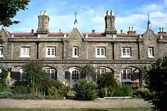
- There are several Victorian almshouses in Penge, the oldest being the Free Watermen and Lightermen's Almshouses (also known as the Royal Watermen's Almshouses),[24] built in 1840–1841 on Beckenham Road, to designs by George Porter by the Company of Watermen and Lightermen of the City of London, for retired company freemen and their widows.[25] The residents were moved in 1973 to a new site in Hastings and the original buildings were converted into private homes.
- The Queen Adelaide Almshouses, also known as the King William Naval Asylum, St. John's Road, founded in 1847 and built in 1848 to designs by Philip Hardwick at the request and expense of Queen Adelaide of Saxe-Meiningen, the widow of King William IV, to provide shelter for twelve widows or orphan daughters of naval officers. Again, the almshouses are now private residences.[25]
- St. John's Cottages on Maple Road were built as almshouses in 1863, designed by the architect Edwin Nash. As with their predecessors, the cottages are now privately owned homes. On New Year's Day 1959, No.8 was destroyed by a gas explosion, killing one person.[26] The cottage was rebuilt to closely resemble the original.
- The police station at the corner of the High Street and Green Lane is believed to have been London's oldest working police station[27] when it was closed in 2010.
- When completed in 1956 the Crystal Palace Transmitter was the tallest structure in the UK, a record it lost to the Anglia Television transmitter at Belmont, Lincolnshire in 1959. It remained the tallest structure in the London area until 1991.
Gallery
 Waterman's Square Almhouses in 1890
 Waterman's Square Almshouses in 2017
.jpg.webp) Waterman's Square Almshouses in 2017
Waterman's Square Almshouses in 2017 Former Police Station in Penge
Transport
Rail
Penge West station serves the area with National Rail services to London Bridge and Coulsdon Town, as well as London Overground services to Dalston Junction and West Croydon. Penge East and Kent House also serve the area with National Rail services to London Victoria, Bromley South and Orpington.
Buses
Penge is served by London Buses routes 75, 176, 194, 197, 227, 354, 356, 358 and N3. These connect it with areas including Beckenham, Bromley, Camberwell, Catford, Central London, Croydon, Crystal Palace, Elephant & Castle, Elmers End, Farnborough, Forest Hill, Lewisham, Orpington, Peckham, Shirley, South Norwood, Sydenham and West Wickham.
Education
St Johns C.E. Primary School was originally part of the Old Penge Chapel, which opened in 1837. Early in the 1850s, following the completion of St John the Evangelist, the school took over the entire old chapel building. The school's site was extended in 1977, and a new school building was opened in September 1978.[28]
The Beckenham and Penge County Grammar School for boys, formerly the Beckenham Technical Institute which opened in 1901, moved to a new site on Penge High Street between Kent House Road and Kingsdale Road in 1931. It moved from Penge to its present location in Eden Park, Beckenham, in January 1969.
Religious sites
.jpg.webp)
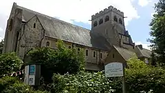
St John the Evangelist's Church, Penge (pictured right) in Beckenham Road, was built in 1850 to designs by Edwin Nash & J. N. Round.[25] Penge Congregational Church was built in 1912 to designs by P. Morley Horder with passage aisles and clerestory, shafts on large, excellently carved corbels,[25] and a stained glass window by William Morris.
Sport
Crystal Palace Park contains the National Sports Centre, which includes an international-class athletic stadium, and a former motorsport circuit that was used in the 1969 film The Italian Job.[29] The Crystal Palace Park once housed a football ground, which hosted the FA Cup final from 1895[30] to 1914, as well as London County Cricket Club games from 1900 to 1908, when the club folded, and Crystal Palace FC's matches from their formation in 1905 until the club was forced to relocate during the First World War. Other facilities include Alexandra Recreation Ground, Penge Recreation Ground and Royston Playing Fields. There is a municipal golf course across the borough boundary in Beckenham Place Park.
Cultural references
After the Crystal Palace was moved to Penge Place, a fashionable day out was to visit the Crystal Palace during the day and to take the tram down the hill to one of the 'twenty-five pubs to the square mile'[20] or two Music Halls.
- Horace Rumpole, a barrister known as "Rumpole of the Bailey", frequently tells others of his greatest triumph, winning an acquittal in the Penge Bungalow Murders "alone and without a leader." Author John Mortimer's original chronology was incorrect, as the Penge bungalows were prefabricated houses which replaced homes destroyed during the Second World War, long after the date of Rumpole's claimed triumph. When the details of the trial were later documented by Mortimer in the novel Rumpole and the Penge Bungalow Murders in 2002, he moved the events to the early 1950s.
Notable residents
- Thomas Crapper, the famous Victorian manufacturing plumber, retired to live at 12 Thornsett Road (c. 1897–1910). He is commonly, but erroneously, credited with inventing the flush toilet.[31] He did however develop the U-bend, a significant improvement on the S-bend, which the BBC has nominated as one of the 50 Things That (have) Made the Modern Economy.[32]
- Barbara Strang, an English language scholar was born here in 1925.
- Joseph Petrus Hendrik Crowe, Victoria Cross recipient, died at Penge in 1876.
- Walter de la Mare, famous poet and author of ghost stories, resided at 195 Mackenzie Road, Beckenham (1899–1908) then moved to 5 Worbeck Road (1908–1912) and 14 Thornsett Road (1912–1925).[33]
- John Freeman, Georgian poet and essayist. He was a friend of Walter de la Mare.[34]
- Camille Pissarro, French impressionist painter, lived in Penge in the 1870s.[31]
- H. T. Muggeridge, British politician, father of Malcolm Muggeridge
- Malcolm Muggeridge, British journalist, author, satirist, media personality, soldier-spy and latterly Christian apologist.[35]
- Bonar Law, Prime Minister, who was the Member of Parliament for Dulwich and lived in Oakfield Road in Penge.[35]
- John Clunies-Ross, first King of the Cocos Islands[35]
- Tom Hood (1835–1874), author, playwright and editor of Fun magazine lived at 12 Queen Adelaide Road.[35]
- Helena Normanton (1882–1957), was the first woman to practise as a barrister in the UK.[35]
- Herbert Strudwick Surrey and England wicket-keeper, lived at 4 Worbeck Road.[35]
- Bill Wyman (born 1936), bassist with The Rolling Stones, lived in Penge as a child.[36]
- Frank Spencer, band leader, and his wife Peggy Spencer, choreographer (both MBE), were regular contributors to the BBC TV show Come Dancing in the 1960s and 1970s, and lived at 12 Percy Road.
- George Daniels, CBE (1926–2010), watchmaker and inventor of the Coaxial escapement as used by Omega watches, lived in Thornsett Road and is commemorated by a blue plaque.[37]
- Monica Furlong [1930–2003], celebrated religious affairs correspondent, journalist and novelist lived in Station Road and once edited Spire, the magazine of Holy Trinity Church, Lennard Road.
- Arthur Carnall [1853–1904], composer and organist, lived at 20 Avington Grove. For many years he was the organist of St John the Evangelist Church on Penge High Street. His music has seen a revival and is played and recorded throughout Europe.
References
- Quest for Justice, VOL 9/NO 3, JUL/SEP 2003, p219
- in Abbott, Peter (2002) Book of Penge, Anerley and Crystal Palace: The Community, Past Present and Future, p18 Halsgrove. ISBN 1-84114-210-7
- Abbott, Peter (2002) Book of Penge, Anerley and Crystal Palace: The Community, Past Present and Future, p48 Halsgrove. ISBN 1-84114-210-7
- Abbott, Peter (2002) Book of Penge, Anerley and Crystal Palace: The Community, Past Present and Future, p10 Halsgrove. ISBN 1-84114-210-7
- "The Crooked Billet, on Penge Common", The Every-day Book and Table Book; or, Everlasting Calendar of Popular Amusements, Sports, Pastimes, Ceremonies, Manners, Customs, and Events, Each of the Three Hundred and Sixty-Five Days, in Past and Present Times; Forming a Complete History of the Year, Months, and Seasons, and a Perpetual Key to the Almanac, Including Accounts of the Weather, Rules for Health and Conduct, Remarkable and Important Anecdotes, Facts, and Notices, in Chronology, Antiquities, Topography, biography, Natural History, Art, Science, and General Literature; Derived from the Most Authentic Sources, and Valuable Original Communication, with Poetical Elucidations, for Daily Use and Diversion. Vol III., ed. William Hone, (London: 1838) p 669-74.
- "familygrowsontrees.com - familygrowsontrees Resources and Information". ww1.familygrowsontrees.com.
- Abbott, Peter (2002) Book of Penge, Anerley and Crystal Palace: The Community, Past Present and Future, p114 Halsgrove. ISBN 1-84114-210-7
- http://www.ideal-homes.org.uk/bromley/penge/empire-theatre.htm Archived 26 May 2006 at the Wayback Machine idealhomes.org.uk
- http://viewfinder.english-heritage.org.uk/search/reference.asp?index=565&main_query=&theme=&period=&county=&district=&place_name=London&imageUID=77020&=&JS=True Archived 1 October 2007 at the Wayback Machine viewfinder.english.heritage.org.uk
- http://www.mappalondon.com/london/south-east/map-london.htm mappalondon.com
- http://www.museumoflondon.org.uk/postcodes/places/SE20/stories/CAT122.html Archived 12 July 2007 at the Wayback Machine museumoflondon.org.uk
- The Penge Murder, H. Sutherland, British Medical Journal v2 (766) 4 September 1875, 316–317
- The Great Penge Murder, Victorian Calendar 19 September 1877 http://victoriancalendar.blogspot.com.au/2011/09/september-19-1877-great-penge-murder.html
- Rachel Cooke (15 April 2012). "The Penge Mystery: the terrible story of Harriet Staunton". The Observer. Retrieved 8 March 2014.
- British History Online – Battersea with Penge Hamlet
- Kelly's Directory of Surrey, 1891
- Hamlet of Penge, The Times, 27 February 1900
- https://www.british-history.ac.uk/vch/surrey/vol4/pp8-17
- https://books.google.co.uk/books/about/Around_Crystal_Palace_and_Penge.html?id=UMjvGwAACAAJ&source=kp_book_description&redir_esc=y
- Abbott, Peter, p114
- "The listed pubs of London". www.ucl.ac.uk. Retrieved 6 April 2018.
- https://www.tensionfineart.co.uk
- "Penge Green Gym - Community Gardening Volunteers - Friends of Winsford Gardens". www.pengegreengym.org.uk. Retrieved 6 April 2018.
- http://www.ideal-homes.org.uk/bromley/penge/royal-watermans.htm Archived 21 April 2009 at the Wayback Machine ideal-homes.org.uk
- John Newman. West Kent and the Weald. The "Buildings of England" Series, First Edition, Sir Nikolaus Pevsner and Judy Nairn, eds. (London: Penguin, 1969), p.433.
- Housewife dies in Maple Road blast, 'Beckenham and Penge Advertiser', 8 January 1959, p1.
- http://www.ideal-homes.org.uk/bromley/penge/police-station.htm Archived 19 October 2003 at the Wayback Machine ideal-homes.org.uk
- http://www.st-johnsprimary.co.uk/about-us
- The television transmitter is visible in the scene where they try to blow the doors off an armoured truck.
- "Map of Crystal Palace Park". Crystal Palace Park, Penge, South London. Cadillac Owners Club of Great Britain. Archived from the original on 24 September 2016. Retrieved 29 May 2013.
- Abbott, Peter (2002), p93.
- "S-Bend, 50 Things That Made the Modern Economy - BBC World Service". BBC. Retrieved 6 April 2018.
- Abbott, Peter (2002), p94.
- Pullen, Doris E. (1990) Penge. self-published. ISBN 0-9504171-3-0, p72
- Pullen, Doris E. (1990), p. 72
- Abbott, Peter (2002), p. 95
- Famous watchmaker remembered with blue plaque, News Shopper (Bromley), 27 August 2014, p. 5.
External links
[[Category:Districts of the London Borough of Bromley .
