Chelsfield
Chelsfield is an area in south-east London, England, within the London Borough of Bromley and the historic county of Kent. It lies south of Goddington, west of Well Hill, north of Pratt's Bottom and east of Green Street Green. The area is split into two distinct areas - the historic 'village' section, and the newer development by the train station.[2]
| Chelsfield | |
|---|---|
 | |
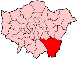
 Chelsfield Location within Greater London | |
| Population | 14,507 (2011 Census. Chelsfield and Pratts Bottom Ward)[1] |
| OS grid reference | TQ482642 |
| London borough | |
| Ceremonial county | Greater London |
| Region | |
| Country | England |
| Sovereign state | United Kingdom |
| Post town | ORPINGTON |
| Postcode district | BR6 |
| Dialling code | 01689 |
| Police | Metropolitan |
| Fire | London |
| Ambulance | London |
| UK Parliament | |
| London Assembly | |
History
The name is recorded in the Domesday Book of 1086 as "Cillesfelle", meaning "land of a man called Cēol".[3][2] Another older variant was 'Chilesfeld'.[2] The village church was constructed in the early Norman period, and gives its names to the Five Bells pubs.[2] Chelsfield was historically a stopping place for drovers.[2]
In 1868 Chelsfield station was opened, however it was located 1 mile west of the village.[2] As a result, in 1925 land near the station was bought by Homesteads Ltd. and developed for housing, thus creating what is sometime referred to as 'New' Chelsfield.[2] Further development occurred after the Second World War, with New Chelsfield eventually merging with Green Street Green and Goddington, however the introduction of the London Green Belt stymied development around the village.[2] The New Chelsfield area is now largely a commuter suburb.
Governance
Chelsfield formed an ancient parish, and later civil parish of 3,378 acres (14 km2), in Kent.[4] The parish included Green Street Green and Pratt's Bottom and stretched as far as Cudham and Orpington.[4] It was part of the Bromley Rural District from 1894.[4] The parish was abolished in 1934 and its former area became part of the Orpington parish and urban district.[5] In 1965 it was transferred to Greater London, to form part of the London Borough of Bromley.[5]
Geography
In practice, Chelsfield is split into two very distinct areas: the historic Chelsfield Village sited to the east of the main Orpington bypass (the A224) and New Chelsfield, which grew up in the first half of the 20th century after the sale of some of the Waring family estates. Although only about 1 mile (1.6 km) apart from each other, they are very different in nature.
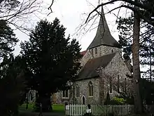
The A224, known as Court Road, now separates the historic village from its Anglican church which is dedicated to St Martin of Tours and which dates back, in parts, to the 12th Century.[6]
Amenities
Chelsfield Village has a primary school, a playground, a village hall, an allotment and a cricket club which is the site of the annual Village Summer Fair. In the 1950s the village fielded a football team of sorts, and in the early 1960s a ladies hockey team had a pitch next to the village hall, with the latter lasting only two seasons. On one corner of the field there was also two tennis courts but unused, they 'disappeared' late in the 60s. There is a pub, the Five Bells, and the church Parish Rooms sited next to the 'new' (70s?) Rectory in Skibbs Lane. There are now no shops at all. Neal's Store - a grocer cum ironmonger - closed in the early 60s. The post office, latterly run by Mrs Lambert, closed at a later date. The privately operated Chelsfield Park Hospital is situated on the outskirts of the village, in extensive grounds. The house had a sweeping staircase going up in the entrance hall. Post-war (WWII) 'Chelsfield House' was used as a 'reception centre' for families awaiting a council house. Certainly, one family moved from here to a council house at Kilnfields, in Hollybush Lane. The 70s map shows Orlestone Gardens next to the village school, and this is the site of the 'old' rectory, and its large rambling gardens which shared a fence with the school playground. In 1962 the gardens were overgrown and neglected, sporting several decaying beehives - and soon after, the 'new' rectory was built in Skibbs Lane.
New Chelsfield has a wide variety of shops along Windsor Drive ranging from a funeral directors and dentist to hairdressers, grocery stores, a betting shop, a fish & chip takeaway and an Indian restaurant. There is also a pub, The Chelsfield (also previously known as The Heavy Horse). Windsor Drive also has the Chelsfield Community Centre, a Methodist church and GP's surgery.
Transport
Chelsfield station connects the area with National Rail services northbound to London Charing Cross via Orpington and Lewisham and southbound to Sevenoaks. Connections can be made at Orpington for London Victoria via Bromley South and Brixton, and at Sevenoaks for Hastings via Tunbridge Wells and to Ramsgate via Ashford International and Canterbury West.
Chelsfield is served by Transport for London bus route R1 to St Paul's Cray via Orpington and to Green Street Green and the R7 to Chislehurst via Orpington. Connections can be made at Orpington for buses to Beckenham, Bexleyheath, Bluewater, Bromley, Catford, Crystal Palace, Dartford, Lewisham, Sidcup, Swanley and Woolwich.
Notable residents
- Brass Crosby (1725-1793) - 18th Century parliamentarian and one-time Lord Mayor of London, lived at Court Lodge where he is commemorated with a blue plaque.[7]
- Edith Nesbit (1858-1924) - children's author who lived at nearby Halstead; her Railway Children is said to have been inspired by her frequent use of Chelsfield station.[2]
- Michael Oakeshott (1901-1990) - philosopher and political theorist, born in Chelsfield.[8]
- Miss Read (1913-2012, birth name Dora Jessie Saint) - author, spent most her childhood in Chelsfield.[2]
- Gary Rhodes (1960-2019) - television Chef, lived in Chelsfield.[9]
Gallery
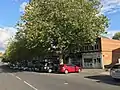 Shops on Windsor Drive, New Chelsfield
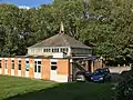 Methodist Church, New Chelsfield
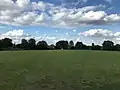 Glentrammon Recreation Ground, New Chelsfield
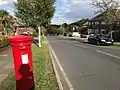 Windsor Drive, New Chelsfield
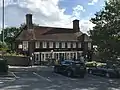 The Chelsfield pub, New Chelsfield
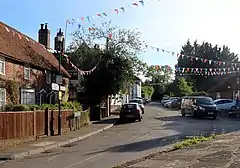
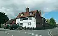 The Five Bells pub, Chelsfield Village, listed at grade II[10]
External links
- http://www.chelsfieldhistory.org.uk/index.htm# Chelsfield Community Archive
- http://meadinkent.co.uk/chelsfieldevents/ Chelsfield Village Events
- http://www.stmartinchelsfield.org.uk/about.html St Martins of Tours Church, Chelsfield
- http://www.thefivebells-chelsfieldvillage.co.uk/ Five Bells Pub, Chelsfield Village
- https://web.archive.org/web/20160322121225/http://gladewoodtaverns.co.uk/chelsfield_orpington.html The Chelsfield Pub
References
- "Bromley Ward population 2011". Neighbourhood Statistics. Office for National Statistics. Archived from the original on 21 October 2016. Retrieved 10 October 2016.
- Willey, Russ (2006). The London Gazetteer. Chambers Harrap Publishers Ltd. pp. 92–3.
- Mills, A., Oxford Dictionary of London Place Names, (2001)
- Vision of Britain - Chelsfield parish (historic boundaries Archived 1 October 2007 at the Wayback Machine)
- Vision of Britain - Orpington parish Archived 11 March 2007 at the Wayback Machine
- http://www.stmartinchelsfield.org.uk/about.html
- "Brass Crosby". Visit Bromley. Retrieved 30 September 2020.
- "Michael Oakeshott". Archives Hub. Retrieved 30 September 2020.
- "Gary Rhodes - Chelsfield Park". News Shopper. 23 August 2004. Retrieved 30 September 2020.
- Historic England. "Five Bells pub (1359343)". National Heritage List for England. Retrieved 1 October 2020.
| Authority control |
|
|---|
