Elmstead, London
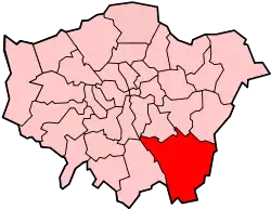
Elmstead is a residential district in south-east London, England, within the London Borough of Bromley and the historic county of Kent. It is located north-east of Bromley.

History
Toponomy
The name is recorded in 1320 as Elmsted and means 'place where elm trees grow'. The name was shared with Elmstead Place mansion and the woodland of Elmstead Wood. After the local railway station opened it took the name Elmstead Woods.[1]
Geography
Elmstead Wood has public access from Elmstead Lane and other locations.[2] It lies on the Green Chain walk. It is adjacent to Sundridge Park Golf Club.
Elmstead Pit, opposite the railway station, is a geological Site of Special Scientific Interest which has important fossils from the Eocene epoch 50 million years ago.[3][4]
Nearby areas
Elmstead borders Mottingham to the north and north east, Chislehurst to the east and south east, Bickley to the south, Sundridge to the south west and west and Grove Park to the north west.
Transport
Rail
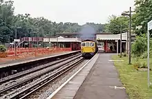
Elmstead Woods railway station serves the area with Southeastern services to London Charing Cross and London Cannon Street via Lewisham as well as to Orpington and Sevenoaks.
Buses
Elmstead is served by one Transport for London bus service.
- 314 to Eltham and to New Addington via Bromley.
Sport
Elmstead has a senior football club, F.C. Elmstead, who play at Oakley Road in Bromley.
References
- Mills, D. (2000). Oxford Dictionary of London Place Names. Oxford.
- Elmstead Wood, Bromley Council
- Elmstead Pit, Natural England citation
- Elmstead Pit, Natural England, Nature on the Map