Coney Hall
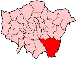
Coney Hall is an area of Greater London, within the London Borough of Bromley and the historic county of Kent. It is located south of Hayes, west of Keston, north of Nash, and east of West Wickham. The Prime Meridian passes through Coney Hall.[1]

History
Coney Hall Farm was first mentioned in the 17th century, when its lease stated that the tenant had the sole right to catch coneys (rabbits) on nearby Jackson’s Heath.[2][1]
Coney Hall is one of many owner-occupied estates arising during the inter-War housing boom; it was built in the 1930s on hilly farmland south-east of West Wickham by the developers Morrell Brothers, who purchased Coney Hall Farm following the death of its owner Sir Henry Lennard in 1928.[1] In the previous decade, Lennard's opposition to road developments adjacent to West Wickham Common and Hayes Common had left the area accessible only by steep and narrow lanes.[1] In Coney Hall's early days London Transport refused to provide a bus service, and a free private coach service connected the estate to the nearest railway station, Hayes.[1] The quality of the new houses was not always that high, with a mortgage strike by Elsy Borders of 81 Kingsway in 1937 sparking sympathy strikes elsewhere, and contributing ultimately to an improvement in the legal standing of mortgage payers.[1][3][4] During World War II Canadian troops were billeted at Coney Hall.[1]
The area contains typical suburban architecture of two-storey houses with polygonal bay windows and half-timbered gables. It is centred on a bend on Glebe Road, east of Coney Hall roundabout, with a smaller row of shops on Addington Road.
Transport
Rail
The nearest National Rail station is Hayes station.
Buses
- 119 to Bromley or to Purley Way via West Wickham & Croydon. 24 Hour service. Operated by Go Ahead London for TfL.
- 138 to Bromley. Operated by Go Ahead London for TfL.
- 246 to Bromley or to Westerham via Biggin Hill. Operated by Go Ahead London for TfL.
- 314 to Eltham via Bromley or to New Addington. Operated by Stagecoach London for TfL.
- 353 to Ramsden Estate via Orpington or to Forestdale. Operated by Go Ahead London for TfL.
Public spaces and sport
- The Assembly Halls (Community centre)[5]
- Coney Hall Recreation Ground (tennis courts, playground, skatepark[6] and green space) [7]
- Well Wood (woods and green space).[8] 41.61 acres (16.84 ha) The Well Wood consists of ancient semi-natural woodland with oak, ash, hazel, yew, sweet chestnut, field maple, hawthorn, Douglas fir and larch, containing masses of wood anemones and wood sorrel, followed by a carpet of bluebells; it is frequented by bats, badgers, foxes, owls, woodpeckers, buzzards and many other birds.
The local football club, Coney Hall FC, once played as high as the Combined Counties League Premier Division, but folded in 2016.[9]
Layhams Road runs south from Coney Hall towards the North Downs, and is a popular cycling route.[10]
Gallery
 Welcome sign on Glebe Way
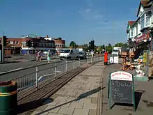
 Coney Hall roundabout
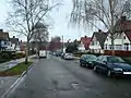 Typical housing in Coney Hall
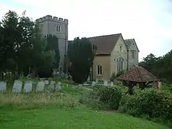 St John's Church
References
- Willey, Russ. Chambers London Gazetteer, pgs 115-16
- "Coney Hall - Hidden London". hidden-london.com. Retrieved 27 March 2017.
- McCulloch, Andrew (6 June 2001). "The Mortgage Strikes". History Today. Retrieved 21 March 2020.
- Jackson, Alan A. (12 January 2018). Semi-Detached London: Suburban Development, Life and Transport, 1900-39. Routledge. ISBN 978-1-351-17512-8.
- http://www.bromley.gov.uk/directory_record/1210158/assembly_halls_-_west_wickham
- "Guide to Coney Hall Skatepark". The Skateparks Project. 9 September 2018. Retrieved 18 December 2018.
- "Archived copy". Archived from the original on 17 June 2014. Retrieved 27 March 2014.CS1 maint: archived copy as title (link)
- "Well Wood | Explore woods | The Woodland Trust". www.woodlandtrust.org.uk. Retrieved 18 December 2018.
- https://twitter.com/ConeyFc/status/711289744735531008
- Road Cycling UK https://roadcyclinguk.com/blogs/georges-blog/just-a-perfect-day.html
External links
- Historical images of Coney Hall
- "Road Widening In Kent Approaches To Hayes Common", B.M. Goodwin, Letters, The Times, 20 August 1931.