Gulou District, Xuzhou
Gulou District (simplified Chinese: 鼓楼区; traditional Chinese: 鼓樓區; pinyin: Gǔlóu Qū) is a district of the city of Xuzhou, Jiangsu province, China. It is named after the drum tower of Xuzhou, which built in 1379 but ruined in 1952 because of falling into disrepair. Gulou was a traditional business district before its expansion.
Gulou
鼓楼区 | |
|---|---|
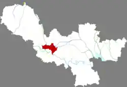 Location in Xuzhou | |
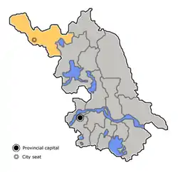 Xuzhou in Jiangsu | |
| Coordinates: 34°16′29″N 117°15′57″E | |
| Country | People's Republic of China |
| Province | Jiangsu |
| Prefecture-level city | Xuzhou |
| Area | |
| • Total | 90.8 km2 (35.1 sq mi) |
| Population (2016) | |
| • Total | 384,500 |
| • Density | 4,200/km2 (11,000/sq mi) |
| Time zone | UTC+8 (China Standard) |
| Postal code | 221005 |
| Website | www |
History
In 1938, the urban area of Tongshan County, namely the former No. 1 District was separated out to establish Xuzhou City by the Japanese military. KMT retained this administrative division. It was renamed Gulou in 1955. After the Cultural Revolution began, it was renamed Yan'an in 1967, thereafter was restored its former name in 1980. Xuzhou Economic and Technological Development Zone was transferred to Gulou from Tongshan in 2005.
Administrative districts
In the present, Gulou District has 8 subdistricts and 1 towns.[1]
| Administrative division | Population | Area (km2) | Density (per km2) |
|---|---|---|---|
| Pipa Subdistrict (琵琶街道) | 29,593 (2010) | 17.7 | 1,672 |
| Huanglou Subdistrict (黄楼街道) | 42,900 (2010) | 1.8 | 23,833 |
| Fengcai Subdistrict (丰财街道) | 76,713 (2010) | 9.7 | 7,909 |
| Huancheng Subdistrict (环城街道) | 83,311 (2010) | 3.6 | 23,142 |
| Pailou Subdistrict (牌楼街道) | 22,012 (2010) | 4.45 | 4,947 |
| Tongpei Subdistrict (铜沛街道) | 50,756 (2010) | 6 | 8,459 |
| Donghuan Subdistrict (东环街道) | 24,932 (2010) | 3.7 | 6,738 |
| Jinshanqiao Subdistrict (金山桥街道) | 31,598 (2010) | 7 | 4,514 |
| Miaoshan Town (庙山镇) | - | - | N/A |
- Jiuli Subdistrict (九里街道) is merged to other.
References
- "徐州市-行政区划网 www.xzqh.org" (in Chinese). XZQH. Retrieved 2012-05-24.
- www.xzqh.org (in Chinese)