Xiangshui County
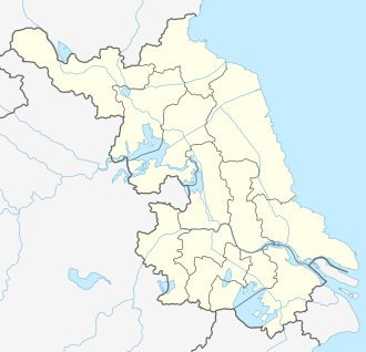
Xiangshui County (simplified Chinese: 响水县; traditional Chinese: 响水縣; pinyin: Xiǎngshuǐ Xiàn; lit. 'loud water'[2]) is a coastal county under the administration of Yancheng, Jiangsu province, China. The northernmost county-level division of Yancheng, it borders the prefecture-level cities of Lianyungang to the northwest and Huai'an to the southwest. The county was founded in April 1966.[2]
Xiangshui
响水县 | |
|---|---|
 GuanHe Bridge | |
 Xiangshui Location in Jiangsu | |
| Coordinates: 34°12′54″N 119°48′14″E[1] | |
| Country | People's Republic of China |
| Province | Jiangsu |
| Prefecture-level city | Yancheng |
| Area | |
| • Total | 1,461 km2 (564 sq mi) |
| Population | |
| • Total | 600,000 |
| • Density | 410/km2 (1,100/sq mi) |
| Time zone | UTC+8 (China Standard) |
| Postal code | 224600 |
| Area code(s) | 0515 |
| Website | xiangshui |
Administrative Divisions
There are eight towns and three other areas under the jurisdiction of Xiangshui County:[2][3][4]
8 towns:
|
|
3 other areas:
- Xiangshui County Economic and Technological Development Zone (县)
- Huanghai Farm (省属)
- Guandong Saltern (省属)
Former townships (They are merged to other.):
Geography

On its northern territory, the Guanhe River, an inner river of Jiangsu, flows through from west to east until running into the Yellow Sea. The county owns 43 km of the coastal line, facing Japan and Korea by crossing the sea. Stunning local residents over years, tens of false killer whales from the Yellow Sea had swum back into its watergate as deep as 10 km. Covered by abundance of an aquatic plant species, shallow water lotus, the county is honored as a "Town of Shallow Water Lotus".
Principal natural resources include its marine area and marshland. The county is currently the largest site for sea salt production in China.
Climate
Xiangshui county has an oceanic monsoon climate with humid changeable wind and distinct four seasons. The average temperature is 14 °C with the hottest 38.7 °C in July and the coldest -17 °C in January. The raining season is from the middle of June to July and the average annual precipitation is 1,000 mm. There are 209 days free of frost.
Transport
Xiangshui's road transportation mainly relies on G204, S307, Jinghu (Beijing-Shanghai) Expressway and the Jiangsu Coastline Expressway, in which G204 and S307 run through the county from east to west but Jinghu and Coastline Expressway go the north–south direction. Its water transportation relies on two major rivers, the Tongyu Canal and Guanhe River. Chengjiagang Port, located at the mouth of Guanhe rive, opens to international cargo transportation. The port is 36 km (22 mi) away from Lianyungang Port.
Air travellers are serviced by the Yancheng Nanyang International Airport, and Huai'an Lianshui Airport.
Economy
Xiangshui was traditionally a poor county, and was a testing ground for Jiangsu's economic reform policies. Its 2018 GDP was around 34.5 billion yuan, or a per capita GDP of approximately $8,300, low by Jiangsu standards. By 2018, it had joined the ranks of the "top one hundred counties for investment potential", signalling its more recent economic growth.[5]
Xiangshui was a traditional salt-making site but now it is an important agricultural land. The agricultural income occupies 30% of the county revenue. Principal agricultural products include rice, cotton, fruit, livestock and vegetable. In addition, aquatic production has earned the county a national reputation with more than 200 sea food products including fish, crab, shrimp, etc. The county's industrial sectors are still in its early shape, including textile, chemicals, machinery, food manufacturing and pharmaceuticals.
Before 2000, Xiangshui is an agricultural land with uncontaminated environment and it still owns a well shaped ecosystem. However, due to more strict regulations in the more prosperous southern parts of Jiangsu province, chemical plants began moving to the relatively poor northern Jiangsu region. These chemical factories usually enjoyed the preferential treatment from the local Xiangshui government. Lacking or without strict regulation and supervision, these chemical plants brought pollution and environmental damage to the county. On November 27, 2007, an explosion occurred in one of the chemical factories in Chenjianggang Chemical Zone, with seven killed and many injured. On March 21, 2019, a major explosion occurred at a chemical plant in Chenjiagang Town. A total of 78 people were killed and more than 600 injured.
References
- Google (2014-07-02). "Xiangshui" (Map). Google Maps. Google. Retrieved 2014-07-02.
- 响水概况 [Xiangshui Overview] (in Chinese). 盐城市响水县人民政府办公室. 3 January 2019. Retrieved 29 March 2019.
1966年4月经国务院批准正式建立,因县政府驻响水镇,滨临灌河,河床深阔,潮水涨落时水位落差大,支流汇入跌水声轰响,故名响水。{...}总面积1461平方公里,下辖8个镇、3个工业园区,60万人口,
- 响水县历史沿革 [Xiangshui County Historical Development] (in Chinese). XZQH.org. 17 December 2012. Retrieved 30 March 2019.
辖4个镇、12个乡:响水镇、小尖镇、大有镇、陈港镇、海安集乡、老舍乡、港南乡、南河乡、响南乡、双港乡、六套乡、七套乡、运河乡、周集乡、张集乡、黄圩乡。{...}2005年,响水县辖8个镇、4个乡:响水镇、陈家港镇、小尖镇、黄圩镇、大有镇、双港镇、南河镇、运河镇、张集乡、六套乡、七套乡、老舍乡。{...}2009年末,响水县总面积1461平方千米、总人口17.69万户、60.93万人。{...}2010年,撤销七套乡,并入大有镇;撤销六套乡,并入运河镇;撤销老舍乡,并入双港镇;撤销张集乡,并入小尖镇。调整后,全县辖8个镇:响水镇、陈家港镇、小尖镇、黄圩镇、大有镇、双港镇、南河镇、运河镇。
- 2018年统计用区划代码和城乡划分代码:响水县 [2018 Statistical Area Numbers and Rural-Urban Area Numbers: Xiangshui County] (in Chinese). National Bureau of Statistics of the People's Republic of China. 2018. Retrieved 30 March 2019.
统计用区划代码 名称 320921100000 响水镇 320921101000 陈家港镇 320921102000 小尖镇 320921103000 黄圩镇 320921104000 大有镇 320921105000 双港镇 320921106000 南河镇 320921107000 运河镇 320921400000 县开发区 320921401000 省属黄海农场 320921402000 省属灌东盐场
- "2018年中国中小城市科学发展指数研究成果发布(一)". People.cn. October 8, 2018.
.jpg.webp)