Hörgársveit
Hörgársveit is a municipality located in north-central Iceland, in Northeastern Region. Its seat is the village of Lónsbakki.
Hörgársveit | |
|---|---|
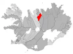 Location of Hörgársveit | |
 Hörgársveit Location of Hörgársveit | |
| Coordinates: 65.457247°N 18.8277973°W | |
| Country | Iceland |
| Region | Northeastern Region |
| Constituency | Northeast Constituency |
| Government | |
| • Manager | Snorri Finnlaugsson |
| Area | |
| • Total | 893 km2 (345 sq mi) |
| Population | |
| • Total | 559 |
| • Density | 0.63/km2 (1.6/sq mi) |
| Municipal number | 6515 |
| Website | horgarsveit |
.jpg.webp)
National Road No. 1, Öxnadalsheiði, Hörgársveit
History
The former municipality of Hörgárbyggð was formed on 1 January 2001 by the union of the municipalities of Skriða (Skriðuhreppur), Öxnadalur (Öxnadalshreppur) and Glæsibær (Glæsibæjarhreppur). In 2010 Hörgárbyggð merged with the municipality of Arnarnes (Arnarneshreppur) to form the current municipality of Hörgársveit.
Geography
Located on the Eyjafjörður, to the north of Akureyri, Hörgársveit is made up of several villages, principally Þelamörk, Lónsbakki (115 inhabitants) and Hjalteyri (37 inhabitants), the seat of the former municipality of Arnarnes.
References
This article is issued from Wikipedia. The text is licensed under Creative Commons - Attribution - Sharealike. Additional terms may apply for the media files.