Skútustaðahreppur
Skútustaðahreppur is a rural municipality located in East Iceland, in Northeastern Region. Its seat is in the village of Reykjahlíð.[1]
Skútustaðahreppur | |
|---|---|
 Coat of arms | |
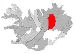 Location of Skútustaðahreppur | |
 Skútustaðahreppur Location of Skútustaðahreppur | |
| Coordinates: 65.6436192°N 16.9173658°W | |
| Country | Iceland |
| Region | Northeastern Region |
| Constituency | Northeast Constituency |
| Government | |
| • Manager | Jón Óskar Pétursson |
| Area | |
| • Total | 6,036 km2 (2,331 sq mi) |
| Population | |
| • Total | 399 |
| • Density | 0.07/km2 (0.2/sq mi) |
| Postal code(s) | 660 |
| Municipal number | 6607 |
| Website | myv |
Geography
Skútustaðir is one of the largest Icelandic municipalities. Its southern borders are represented by the northern site of the glacier of Vatnajökull. Its territory includes the lakes of Mývatn (in front of Reykjahlíð) and Öskjuvatn; and the volcanoes of Hverfjall, Askja, Krafla and Herðubreið.
Photogallery
.jpg.webp) Mývatn Nature Baths
Mývatn Nature Baths.jpg.webp) The Drekagil (canyon of dragons) in Askja
The Drekagil (canyon of dragons) in Askja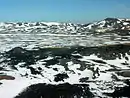 Aerial view of Krafla
References
- "Google Earth". earth.google.com. Retrieved 2020-10-17.
External links
![]() Media related to Skútustaðahreppur at Wikimedia Commons
Media related to Skútustaðahreppur at Wikimedia Commons
- Official website (in Icelandic)
This article is issued from Wikipedia. The text is licensed under Creative Commons - Attribution - Sharealike. Additional terms may apply for the media files.