Hveragerði
Hveragerði is a town and municipality in the south of Iceland, 45 km east of Reykjavík on Iceland's main ringroad, Route 1. The river Varmá runs through the town.
Hveragerðisbær | |
|---|---|
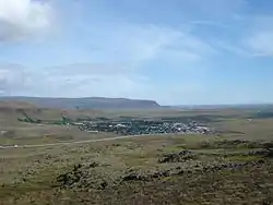 View from Hellisheiði down over Hveragerði | |
 Coat of arms | |
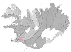 Location of Hveragerðisbær | |
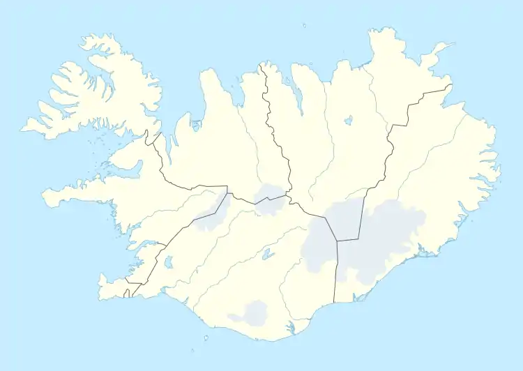 Hveragerðisbær Location of Hveragerðisbær | |
| Coordinates: 63.9992211°N 21.2065315°W | |
| Country | Iceland |
| Region | Southern Region |
| Constituency | South Constituency |
| Government | |
| • Manager | Aldís Hafsteinsdóttir |
| Area | |
| • Total | 9 km2 (3 sq mi) |
| Population | |
| • Total | 2,657 |
| • Density | 295.22/km2 (764.6/sq mi) |
| Postal code(s) | 810 |
| Municipal number | 8716 |
| Website | hveragerdi |


Overview
The surrounding area is part of the Hengill central volcano, and is geothermally active and experiences very frequent (usually minor) earthquakes. The town is known for its greenhouses, which are heated by hot water from volcanic hot springs. These springs are the site of occurrence of certain extremophile micro-organisms, that are capable of surviving in extremely hot environments. Close to the church is a hot spring called Sandhólshver, formed during the violent South Iceland earthquake of 1896. A fenced-off geothermal area in the town has numerous hot springs and fumaroles.
Hveragerði contains a number of greenhouses and is a hotbed for Icelandic horticulture.
To the south of Hveragerði, there is the small port of Þorlákshöfn, winter point of departure for the ferry to the Westman Islands.
Sport
The local football club is Hamar, who play in Iceland's fourth tier.
Twin towns – sister cities
Hveragerði is twinned with:[1]
 Äänekoski, Finland
 Ikast-Brande, Denmark
 Örnsköldsvik, Sweden
 Sigdal, Norway
 Tarp, Germany
Climate
| Climate data for Reykir í Ölfusi (1981–2000) | |||||||||||||
|---|---|---|---|---|---|---|---|---|---|---|---|---|---|
| Month | Jan | Feb | Mar | Apr | May | Jun | Jul | Aug | Sep | Oct | Nov | Dec | Year |
| Record high °C (°F) | 8.2 (46.8) |
9.0 (48.2) |
8.6 (47.5) |
15.1 (59.2) |
19.2 (66.6) |
24.0 (75.2) |
23.3 (73.9) |
21.0 (69.8) |
18.5 (65.3) |
13.0 (55.4) |
10.9 (51.6) |
10.5 (50.9) |
24.0 (75.2) |
| Average high °C (°F) | 2.2 (36.0) |
2.2 (36.0) |
2.2 (36.0) |
5.0 (41.0) |
9.3 (48.7) |
12.2 (54.0) |
14.0 (57.2) |
13.2 (55.8) |
10.3 (50.5) |
6.3 (43.3) |
3.8 (38.8) |
2.4 (36.3) |
6.9 (44.5) |
| Daily mean °C (°F) | −0.2 (31.6) |
−0.1 (31.8) |
-0.0 (32.0) |
2.2 (36.0) |
6.2 (43.2) |
9.0 (48.2) |
10.8 (51.4) |
10.3 (50.5) |
7.6 (45.7) |
4.3 (39.7) |
1.8 (35.2) |
0.1 (32.2) |
4.3 (39.8) |
| Average low °C (°F) | −2.7 (27.1) |
−2.6 (27.3) |
−2.6 (27.3) |
−0.1 (31.8) |
3.8 (38.8) |
6.7 (44.1) |
8.6 (47.5) |
8.3 (46.9) |
5.4 (41.7) |
2.1 (35.8) |
−0.3 (31.5) |
−2.1 (28.2) |
2.0 (35.7) |
| Record low °C (°F) | −14.4 (6.1) |
−12.7 (9.1) |
−14.9 (5.2) |
−10.1 (13.8) |
−7.3 (18.9) |
−1.3 (29.7) |
2.1 (35.8) |
0.9 (33.6) |
−3.1 (26.4) |
−7.1 (19.2) |
−11.2 (11.8) |
−13.7 (7.3) |
−14.9 (5.2) |
| Average precipitation mm (inches) | 138.5 (5.45) |
139.6 (5.50) |
145.6 (5.73) |
110.0 (4.33) |
127.0 (5.00) |
112.7 (4.44) |
141.5 (5.57) |
159.1 (6.26) |
137.8 (5.43) |
149.3 (5.88) |
133.1 (5.24) |
146.2 (5.76) |
1,640.4 (64.59) |
| Mean monthly sunshine hours | 18.2 | 46.4 | 100.8 | 147.5 | 159.0 | 150.8 | 142.3 | 125.2 | 112.2 | 81.3 | 40.3 | 14.1 | 1,138.1 |
| Source: Icelandic Met Office[2] | |||||||||||||
See also
References
- "Vinabæir". hveragerdi.is (in Icelandic). Hveragerði. Retrieved 2020-02-12.
- "Climate Averages for Reykir í Ölfusi". Icelandic Meteorological Office. Retrieved 7 June 2016.
External links
| Wikimedia Commons has media related to Hveragerði. |
- Official website (in Icelandic)

| Authority control |
|
|---|