Hawaiian Gardens, California
Hawaiian Gardens is a city in Los Angeles County, California, United States. It is the smallest city in the county (approximately 1.0 mi²) and was incorporated on April 9, 1964. The population was 14,254 at the 2010 census, down from 14,779 at the 2000 census.
Hawaiian Gardens, California | |
|---|---|
City | |
| City of Hawaiian Gardens | |
 Seal | |
| Motto(s): "Our Youth, Our Future" | |
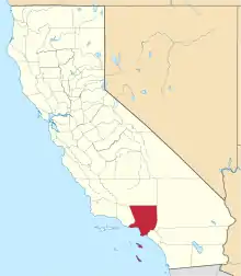
 Location of Hawaiian Gardens in Los Angeles County, California. | |
 Hawaiian Gardens, California Location in the United States | |
| Coordinates: 33°49′43″N 118°4′25″W | |
| Country | |
| State | |
| County | |
| Incorporated (city) | April 9, 1964[1] |
| Government | |
| • Type | City Council-Administrator |
| • Mayor | Jesse Alvarado[2] |
| • Mayor Pro Tem | Luis Roa[2] |
| • Council Members[2] | Myra Maravilla Victor Farfan Hank Trimble |
| Area | |
| • Total | 0.96 sq mi (2.48 km2) |
| • Land | 0.95 sq mi (2.45 km2) |
| • Water | 0.01 sq mi (0.03 km2) 1.09% |
| Elevation | 33 ft (10 m) |
| Population | |
| • Total | 14,254 |
| • Estimate (2019)[5] | 14,159 |
| • Density | 14,935.65/sq mi (5,768.48/km2) |
| Time zone | UTC-8 (PST) |
| • Summer (DST) | UTC-7 (PDT) |
| ZIP code | 90716 |
| Area code(s) | 562 |
| FIPS code | 06-32506 |
| GNIS feature ID | 1652716 |
| Website | hgcity |
The town's unusual name originated with a 1920s refreshment stand that was decorated with palm fronds and bamboo. It was the then-rural area's main landmark for many years, and its name stuck as the small town grew up around it. As one of seven Los Angeles County cities that allow casino gambling, more than $9.2 million (65%) of the city's revenue comes from the Gardens Casino.[6]
Geography
Hawaiian Gardens is located at 33°49′43″N 118°4′25″W (33.828565, -118.073646).[7] It is bounded by the Los Angeles County cities of Long Beach and Lakewood, and by the Orange County city of Cypress.
According to the United States Census Bureau, the city has a total area of 1.0 square mile (2.6 km2). 1.0 square mile (2.6 km2) of it is land and 0.01 square miles (0.026 km2) of it (1.09%) is water. Hawaiian Gardens is the smallest city in area in Los Angeles County.
History
In 1927, a fruit stand with palms was opened on the corner of two dirt roads of Carson and Norwalk called Hawaiian Gardens. Thus, the name was born. The area was a refuge for people to buy or build a home during the Great Depression. Many homes lacked basic modern conveniences.
In the late 1920s, only Norwalk Blvd was a paved road. For the next 35 years, with the exceptions of Pioneer Boulevard, Norwalk Boulevard, and Carson, the little town would be all dirt roads. When the city was incorporated in 1964, the paving of roads began immediately. By 1966, all streets south of Carson between Pioneer and Norwalk were paved. By 1968, all streets were paved, and the three major thoroughfares of Norwalk, Pioneer, and Carson were widened to current traffic standards.
Historic structures lost
- Van Kampen Dairy Drive-In (1959–2011); razed for parking lot in 2013; SW Corner of Norwalk and 226th Streets
- Bloomfield Elementary School (1924–1986); sold for $3 million in lieu of current shopping center; 12100 Carson St
- Homebase Warehouse Store (1989–2007); sold and razed for the current bingo club at 21900 Norwalk Blvd.
- Historic Section at 22100–21700 Norwalk Boulevard; razed in 1989 for Homebase Warehouse Store. This whole east side of Norwalk Boulevard had a few cafes, businesses, and beauty salons, some of which dated back to the 1950s.
- Plowboys Market (1956–1999); family-owned supermarket replaced by the Gardens Casino; there were also other businesses replaced, including a Pic 'N' Save
- The original Hawaiian Gardens City Hall (1964–1979); building razed 1988 for Gardens Shopping Center; 12134 Tilbury St.
- The original Hawaiian Gardens Library (1979–1988); building razed 1988 for Gardens Shopping Center; 12134 Tilbury St.
Demographics
| Historical population | |||
|---|---|---|---|
| Census | Pop. | %± | |
| 1930 | 88 | — | |
| 1940 | 432 | 390.9% | |
| 1950 | 1,200 | 177.8% | |
| 1960 | 2,100 | 75.0% | |
| 1970 | 9,052 | 331.0% | |
| 1980 | 10,548 | 16.5% | |
| 1990 | 13,639 | 29.3% | |
| 2000 | 14,779 | 8.4% | |
| 2010 | 14,254 | −3.6% | |
| 2019 (est.) | 14,159 | [5] | −0.7% |
| U.S. Decennial Census[8] | |||
2010
At the 2010 census Hawaiian Gardens had a population of 14,254. The population density was 14,905.0 people per square mile (5,754.9/km2). The racial makeup of Hawaiian Gardens was 6,477 (45.4%) White (7.3% Non-Hispanic White),[9] 546 (3.8%) African American, 178 (1.2%) Native American, 1,513 (10.6%) Asian, 57 (0.4%) Pacific Islander, 4,929 (34.6%) from other races, and 554 (3.9%) from two or more races. Hispanic or Latino of any race were 11,010 persons (77.2%).[10]
The census reported that 14,238 people (99.9% of the population) lived in households, 16 (0.1%) lived in non-institutionalized group quarters, and no one was institutionalized.
There were 3,562 households, 1,930 (54.2%) had children under the age of 18 living in them, 1,819 (51.1%) were married couples living together, 714 (20.0%) had a female householder with no husband present, 337 (9.5%) had a male householder with no wife present. There were 217 (6.1%) partnerships, and 20 (0.6%) same-sex married couples or partnerships. 534 households (15.0%) were one person and 246 (6.9%) had someone living alone who was 65 or older. The average household size was 4.00. There were 2,870 families (80.6% of households); the average family size was 4.33.
The age distribution was 4,576 people (32.1%) under the age of 18, 1,759 people (12.3%) aged 18 to 24, 4,109 people (28.8%) aged 25 to 44, 2,684 people (18.8%) aged 45 to 64, and 1,126 people (7.9%) who were 65 or older. The median age was 28.4 years. For every 100 females, there were 99.4 males. For every 100 females age 18 and over, there were 96.9 males.
There were 3,703 housing units at an average density of 3,872.1 per square mile, of the occupied units 1,577 (44.3%) were owner-occupied and 1,985 (55.7%) were rented. The homeowner vacancy rate was 1.7%; the rental vacancy rate was 4.3%. 6,247 people (43.8% of the population) lived in owner-occupied housing units and 7,991 people (56.1%) lived in rental housing units.
According to the 2010 United States Census, Hawaiian Gardens had a median household income of $42,017, with 24.4% of the population living below the federal poverty line.[9]
2000
At the 2000 census there were 14,779 people in 3,507 households, including 2,868 families, in the city. The population density was 15,389.5 inhabitants per square mile (5,944.0/km2). There were 3,624 housing units at an average density of 3,773.7 per square mile (1,457.5/km2). The racial makeup of the city was 38.24% White, 4.45% Black or African American, 1.28% Native American, 8.80% Asian, 0.74% Pacific Islander, 41.65% from other races, and 4.85% from two or more races. 62.8% of the population were Hispanic or Latino of any race.[11] Of the 3,507 households 52.4% had children under the age of 18 living with them, 53.8% were married couples living together, 19.0% had a female householder with no husband present, and 18.2% were non-families. 14.2% of households were one person and 5.8% were one person aged 65 or older. The average household size was 4.21 and the average family size was 4.52.
The age distribution was 36.8% under the age of 18, 12.6% from 18 to 24, 30.1% from 25 to 44, 14.4% from 45 to 64, and 6.2% 65 or older. The median age was 25 years. For every 100 females, there were 104.9 males. For every 100 females age 18 and over, there were 102.4 males.
The median household income was $34,500 and the median family income was $31,840. Males had a median income of $21,074 versus $20,643 for females. The per capita income for the city was $10,728. About 19.8% of families and 22.1% of the population were below the poverty line, including 27.4% of those under age 18 and 15.2% of those age 65 or over.
Government and infrastructure
City government
The City of Hawaiian Gardens is a general law city and governs itself as a council-manager form of government. The city council is elected at-large. The city council appoints the city manager. The council establishes policies and ordinances and the city manager, assisted by the department heads, implements them.
The city council members must be Hawaiian Gardens residents and registered voters. As specified by the Constitution of California, city elections are non-partisan.
State and federal representation
In the California State Legislature, Hawaiian Gardens is in the 32nd Senate District, represented by Democrat Bob Archuleta, and in the 63rd Assembly District, represented by Democrat Anthony Rendon.[12]
In the United States House of Representatives, Hawaiian Gardens is in California's 38th congressional district, represented by Democrat Linda Sánchez.[13]
Public services
Fire protection in Hawaiian Gardens is provided by the Los Angeles County Fire Department with ambulance transport by Care Ambulance Service.
The Los Angeles County Sheriff's Department operates the Lakewood Station in Lakewood, serving Hawaiian Gardens.[14]
The Los Angeles County Department of Health Services operates the Whittier Health Center in Whittier, serving Hawaiian Gardens.[15]
Hawaiian Gardens is served by the United States Postal Service Los Alamitos Post Office, located at 10650 Reagan St, Los Alamitos, CA 90720.
Education
Hawaiian Gardens is within the ABC Unified School District.
Elementary schools within Hawaiian Gardens include Venn W. Ferguson Elementary School[16] and Hawaiian Elementary School.[17]
Middle schools within Hawaiian Gardens include Pharis F. Fedde Middle School, which was formerly called Killingsworth Junior High School.[18]
Residents are zoned to the following high schools:
Economy
.jpg.webp)
Top employers
According to the City's 2009 Comprehensive Annual Financial Report,[19] the top employers in the city are:
| # | Employer | # of Employees |
|---|---|---|
| 1 | Hawaiian Gardens Casino | 1,000 |
| 2 | Tri-City Regional Medical Center | 350 |
| 3 | City of Hawaiian Gardens | 81 |
| 4 | Total Building Care | 70 |
| 5 | Cypress Garden Villas | 70 |
| 6 | Howard Contracting | 50 |
| 7 | Richmond Plastering | 50 |
| 8 | Patchman | 45 |
| 9 | ABC Unified School District | 40 |
| 10 | Outdoor Living Products | 40 |
See also
References
- "California Cities by Incorporation Date". California Association of Local Agency Formation Commissions. Archived from the original (Word) on October 17, 2013. Retrieved August 25, 2014.
- "City Council". City of Hawaiian Gardens. Retrieved April 23, 2017.
- "2019 U.S. Gazetteer Files". United States Census Bureau. Retrieved July 1, 2020.
- "Hawaiian Gardens (city) QuickFacts". United States Census Bureau. Archived from the original on April 16, 2015. Retrieved April 16, 2015.
- "Population and Housing Unit Estimates". United States Census Bureau. May 24, 2020. Retrieved May 27, 2020.
- City of Hawaiian Gardens (July 13, 2006). "Budget Summary" (PDF). Retrieved December 31, 2006.
- "US Gazetteer files: 2010, 2000, and 1990". United States Census Bureau. February 12, 2011. Retrieved April 23, 2011.
- "Census of Population and Housing". Census.gov. Retrieved June 4, 2015.
- "Archived copy". Archived from the original on April 16, 2015. Retrieved November 10, 2013.CS1 maint: archived copy as title (link)
- "2010 Census Interactive Population Search: CA - Hawaiian Gardens city". U.S. Census Bureau. Archived from the original on July 15, 2014. Retrieved July 12, 2014.
- "U.S. Census website". United States Census Bureau. Retrieved January 31, 2008.
- "Statewide Database". Regents of the University of California. Archived from the original on February 1, 2015. Retrieved April 11, 2015.
- "California's 38th Congressional District - Representatives & District Map". Civic Impulse, LLC.
- "Lakewood Station Archived December 30, 2009, at the Wayback Machine." Los Angeles County Sheriff's Department. Retrieved on January 21, 2010.
- "Whittier Health Center." Los Angeles County Department of Health Services. Retrieved on March 18, 2010.
- "Error".
- "Error".
- "Error".
- "City of Hawaiian Gardens CAFR" (PDF).
External links
- Hawaiian Gardens city homepage
- LA County Disaster Communications Service (DCS) Lakewood Sheriff Station
Destinations from Hawaiian Gardens | ||||||||||
|---|---|---|---|---|---|---|---|---|---|---|
| ||||||||||
| Authority control |
|---|